
Hide
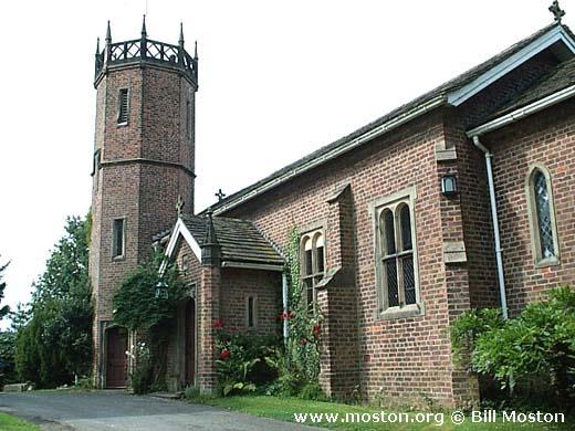
St Catherine, Birtles, Church of England
hide
Hide
Hide
St Catherine,
Birtles Lane,
Birtles
Hide
It was founded in 1840.
Birtles Lane, Over Alderley
Church History
Built in 1840 as a private chapel. In 1890 it became the district church for the townships of Birtles and Over Alderley (previously served by Prestbury: St. Peter and Alderley: St. Mary). The boundaries of "The Consolidated Chapelry of Saint Catherine, Birtles" were described in the London Gazette on 19 August 1890:
"All that portion of the parish of Alderley in tlie county of Chester and in the diocese of Chester which is comprised within and is coextensive with the limits of the township of Over Alderley. And also all that contiguous portion of the parish of Prestbury in the same county and diocese which is comprised within and is co-extensive with the limits of the township of Birtles."
Church Records
C = Christenings (Baptisms) ; M = Marriages ; B = Burials ; BTs = Bishop's Transcripts
| Original Registers | C from 1890 ; M from 1892 ; B from 1891 — Church |
| Copies and Indexes | M 1892-2000 — Cheshire BMD (CE:1012) |
| Monumental Inscriptions | Published by North Cheshire Family History Society |
| Notes | C 1842-1890 — lost |
It is located at SJ8623674831 (Lat/Lon 53.270283, -2.207836). You can see this on maps provided by:
- OpenStreetMap
- Google Maps
- StreetMap (Current Ordnance Survey maps)
- Bing (was Multimap)
- Old Maps Online
- National Library of Scotland (Old Ordnance Survey maps)
- Vision of Britain (Click "Historical units & statistics" for administrative areas.)
- English Jurisdictions in 1851 (Unfortunately the LDS have removed the facility to enable us to specify a starting location, you will need to search yourself on their map.)
- Magic (Geographic information) (Click + on map if it doesn't show)
- GeoHack (Links to on-line maps and location specific services.)