
Hide
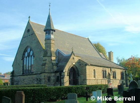
St John the Evangelist, Lindow, Church of England
hide
Hide
Hide
St John the Evangelist,
Knutsford Road,
Lindow
Hide
It was founded in 1874.
Church History
Built in 1874 as a chapel to Chorley: St. Philip & St. James. In 1877 it became the district church for parts of the townships of Chorley, Pownall Fee and Fulshaw (previously served by Chorley: St. Philip & St. James). The boundaries of "The District Chapelry of Saint John, Lindow" were described in the London Gazette on 18 December 1877:
"All that part of the new parish of Saint Philip Chorley, in the county of Chester and in the diocese of Chester, which is bounded on the west partly by the parish of Alderley and partly by the parish of Mobberley, both in the county and diocese aforesaid, on the north and on the east by the parish of Wilmslow in the same county and diocese, and on the remaining side that is to say on the south-east by an imaginary line commencing upon the boundary which divides the said parish of Wilmslow from the new parish of Saint Philip Chorley aforesaid at the centre of White Hall Bridge which carries the Wilmslow and Congleton turnpike-road over the stream called or known as Preston Brook, and extending thence generally south-westward for a distance of two miles or thereabouts along the middle of the said brook to the boundary which divides the said new parish of Saint Philip Chorley, from the parish of Alderley aforesaid."
Church Records
C = Christenings (Baptisms) ; M = Marriages ; B = Burials ; BTs = Bishop's Transcripts
| Original Registers | C from 1875 ; M from 1878 ; B from 1878 — Church |
| Bishop's Transcripts | 1877-1903 (microfilmed) — Cheshire Archives |
| Copies and Indexes | M 1878-2006 — Cheshire BMD (CE:1051) |
| Monumental Inscriptions | North Cheshire Family History Society (edited by A. Clarke), 1990 |
- OpenStreetMap
- Google Maps
- StreetMap (Current Ordnance Survey maps)
- Bing (was Multimap)
- Old Maps Online
- National Library of Scotland (Old Ordnance Survey maps)
- Vision of Britain (Click "Historical units & statistics" for administrative areas.)
- English Jurisdictions in 1851 (Unfortunately the LDS have removed the facility to enable us to specify a starting location, you will need to search yourself on their map.)
- Magic (Geographic information) (Click + on map if it doesn't show)
- GeoHack (Links to on-line maps and location specific services.)