
Hide
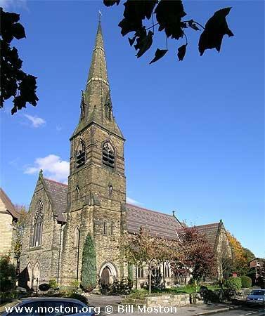
St John the Evangelist, Altrincham, Church of England
hide
Hide
Hide
St John the Evangelist,
Ashley Road/St Johns Road,
Altrincham
Hide
Built in 1866 as a chapel to Altrincham: St. George. In 1867 it became the district church for parts of the townships of Altrincham, Dunham Massey and, Hale (previously served by Dunham Massey: St. Margaret, Timperley: Christ Church, and Bowdon: St. Mary). The boundaries of "The Consolidated Chapelry of Saint John, Altrincham" were described in the London Gazette on 5 November 1867:
"All those contiguous portions of the new parish of Saint Margaret, Dunham Massey, in the county of Chester, and in the diocese of Chester, of the new parish of Timperley, in the same county and diocese, and of the parish, of Bowdon, in the same county and diocese, which are comprised within, and are bounded by, an imaginary line commencing upon the boundary which divides the said parish of Bowdon from the new parish of Saint Margaret, Dunham Massey aforesaid, at the junction of the road which leads from the Church of Saint John, at Altrincham, towards Dunham, with the road called 'the Downs'; and extending thence north-eastward along the middle of the last-named road, and along the middle of Railway-street, as far as a point opposite to the middle of the south-western end of a certain road which leads past the northern side of the Bowdon station of the Manchester and Altrincham Railway, and through Goose-green, and across Hale Moss to Hale Low; and extending thence north-eastward to and along the middle of the last-described road, passing over the line of the Manchester and Altrincham Railway aforesaid, and also the line of the Cheshire Midland Railway, to the boundary which divides the said new parish of Saint Margaret, Dunham Massey, from the district chapelry of Saint George, Altrincham, in the county and diocese aforesaid; and extending thence southeastward along the last-described boundary, still following the last-described road, as far as the junction of such boundary with the boundary dividing the said district chapelry from the new parish of Timperley aforesaid; and continuing thence still south-eastward along the middle of the last-described road, for a distance of ten chains, or thereabouts, to a point opposite to a boundary stone inscribed 'A. St. J. C. C. 1867, No. 1,' and placed on the southern side of the road last referred to; and extending thence southward to the said boundary stone; and continuing thence, still, southward, and in a direct line across Hale Moss, for a distance of six chains, or thereabouts, to another boundary stone inscribed ' A. St. J. C. C. 1867, No. 2,' and placed at the point where the road leading from Lloyd-street, past Lloyd's Hospital, to Hale Low aforesaid, is joined by a certain footpath leading past a cottage and farm in the occupation of William Barton, Farmer, to Long-lane; and continuing thence still in the same direction along the middle of the said footpath, to the boundary in the middle of Long-lane aforesaid, which divides the said new parish of Timperley from the parish of Bowdon aforesaid; and extending thence south-eastward along the last-described boundaiy, following thereby the middle of LongLine cfbresaid, as far as a point opposite to the middle of the north-eastern end of Dob-lane; and extending thence south-westward to and along the middle of the last-named lane, for a distance of thirty-seven chains, or thereabouts, to a point opposite to the middle of the south-eastern end of a certain footpath which connects Dob-lane with the road leading from Ashley, through Peelcauseway, to Bowdon; and extending thence north-westward to and along the middle of the last-described footpath to its junction with the road leading from Ashley, through Peel-causeway, to Bowdon as aforesaid; and continuing thence, first north westward and then westward, along the middle of the same road, to its junction with Ashley-road; and extending thence northward along the middle of the last-named road, for a distance of eleven chains, or thereabouts, to a point opposite to the middle of the eastern end of a certain intended new road leading to Bowdon-road; and extending thence westward to and along the middle of the said intended line of road, for a distance of seventeen chains, or thereabouts, to its junction with a certain other new road leading towards 'the Downs'; and extending thence northeastward along the middle of the last-described new road to its junction with the road leading from the Church of Saint John, at Altrincham, towards Dunham, as aforesaid; and continuing thence, still north-eastward, to the boundary in the middle of the road last referred to, which divides the parish of Bowdon from the new parish of Saint Margaret, Dunham Massey, as aforesaid, and extending thence westward along the last-mentioned boundary, following thereby the middle of the said road, to its junction with the road called 'the Downs,' as aforesaid, where the said imaginary line commenced."
The district was affected by the following boundary changes:
- 1906 July 31 — reduced when part of the township of Hale was transferred to Hale: St. Peter.
C = Christenings (Baptisms) ; M = Marriages ; B = Burials ; BTs = Bishop's Transcripts
| Original Registers | C 1866-1997 ; M 1867-1984 — Cheshire Archives (P 266) C from 1997 ; M from 1984 — Church |
| Microfilm Copies | C 1866-1937 ; M 1867-1984 — Cheshire Archives C 1866-1892 — Trafford Local Studies |
| Bishop's Transcripts | C 1867-1900 (microfilmed) — Cheshire Archives |
| Copies and Indexes | M 1867-1903 — Cheshire BMD (TR:CE4) |
It is located at SJ7662587371 (Lat/Lon 53.382663, -2.352875). You can see this on maps provided by:
- OpenStreetMap
- Google Maps
- StreetMap (Current Ordnance Survey maps)
- Bing (was Multimap)
- Old Maps Online
- National Library of Scotland (Old Ordnance Survey maps)
- Vision of Britain (Click "Historical units & statistics" for administrative areas.)
- English Jurisdictions in 1851 (Unfortunately the LDS have removed the facility to enable us to specify a starting location, you will need to search yourself on their map.)
- Magic (Geographic information) (Click + on map if it doesn't show)
- GeoHack (Links to on-line maps and location specific services.)