
Hide
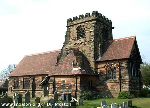
St Cross, Appleton Thorn, Church of England
hide
Hide
Hide
St Cross,
Stetton Road,
Appleton Thorn
Hide
It was founded in 1886.
Stretton Road/Lumb Brook Lane
Church History
Founded in 1887 as the district church for part of the township of Appleton (previously served by Stretton: St. Matthew). The boundaries of "The District Chapelry of Saint Cross, Appleton Thorn" were described in the London Gazette on 27 September 1887:
"All that part of the district parish of Stretton in the county of Chester and in the diocese of Chester wherein the present incumbent of such district parish still possesses the exclusive cure of souls which is bounded upon the south-east partly by the new parish of Saint Mark Antrobus, partly by the parish of Great Budworth, and partly by the parish of Rostherne, upon the north-east by the parish of Lymm upon the north by the parish of Grappenhall and upon the north-west by the new parish of Saint Thomas Stockton Heath, all the said abutting cures being in the county and diocese aforesaid, and upon the remaining sides, that is to say upon the west and upon the southwest by an imaginary line commencing upon the boundary which divides the said new parish of Saint Thomas Stockton Heath from the district parish of Stretton aforesaid at a point in the middle of Lumb Brook distant three hundred yards (measured in a direct line) to the southeast of the southern bank of the Duke of Bridgewater's Canal, and extending thence, that is, from the said boundary, first southward, then southeastward and then again southward along the middle of the said Lumb Brook and along the middle of Dingle Brook for a distance of seventyfive chains or thereabouts to the centre of Dingle Bridge which carries Dingle-lane over the lastnamed brook aud extending thence south-westward along the middle of the last-named lane for a distance of eight chains or thereabouts to its junction with Lyons-lane and extending thence first southward and then south-eastward along the middle of the last-named lane for a distance of thirty-four and a half chains or thereabouts to its junction at Dipping Brook with Cann-lane and continuing thence still south-eastward along the middle of the last-named lane for a distance of forty-two chains or thereabouts to its junction with the high-road which leads from Appleton Thorn to Stretton, and extending thence south-westward along the south-eastern side of the last, mentioned road for a distance of ten chains or thereabouts to a point upon the boundary which divides the township of Appleton from the township of Stretton and extending thence southeastward along the said township boundary for a distance of seventy-seven chains or thereabouts to its junction with the boundary which divides the said district parish of Stretton from the new parish of Saint Mark Antrobus aforesaid."
Church Records
C = Christenings (Baptisms) ; M = Marriages ; B = Burials ; BTs = Bishop's Transcripts
| Original Registers | C 1887-1976 ; M 1887-2012 — Cheshire Archives (P 279) C from 1976 ; M from 2012 ; B from 1888 — Church |
| Copies and Indexes | M 1887-1933 — Cheshire BMD (WA:C1) |
| Monumental Inscriptions | Published by the Family History Society of Cheshire, 1992 |
It is located at SJ6375183853 (Lat/Lon 53.350313, -2.54601). You can see this on maps provided by:
- OpenStreetMap
- Google Maps
- StreetMap (Current Ordnance Survey maps)
- Bing (was Multimap)
- Old Maps Online
- National Library of Scotland (Old Ordnance Survey maps)
- Vision of Britain (Click "Historical units & statistics" for administrative areas.)
- English Jurisdictions in 1851 (Unfortunately the LDS have removed the facility to enable us to specify a starting location, you will need to search yourself on their map.)
- Magic (Geographic information) (Click + on map if it doesn't show)
- GeoHack (Links to on-line maps and location specific services.)