
Hide
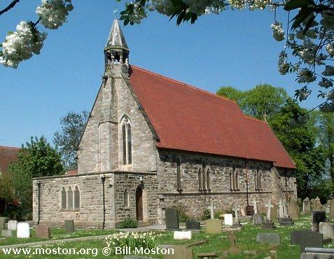
Christ Church, Barnston, Church of England
hide
Hide
Hide
Christ Church,
Barnston Road,
Barnston
Hide
Pensby Road/Gill Lane
Church History
Built in 1870 as the district church for the township of Barnston (previously served by Woodchurch: Holy Cross). The boundaries of "The District of Barnston" were described in the London Gazette on 29 November 1870:
"All that part of the parish of Woodchurch, in the county of Chester, and in the diocese of Chester, which is comprised within and is co-extensive with the limits of the township of Barnston"
The district was affected by the following boundary changes:
- 1880 February 27 — enlarged when the township of Pensby was transferred from Woodchurch: Holy Cross.
- 1959 February 24 — enlarged when the following area was transferred from Woodchurch: Holy Cross: "All that part of the parish of Woodchurch which is bounded on the south by the parish of Barnston, on the southeast by the parish of Bebington and on the remaining sides by an imaginary line commencing at a point on the boundary which divides the parish of Bebington from the parish of Woodchurch in the middle of Prenton Brook opposite the southeastern end of the northeastern boundary of close numbered 4733 (on the map) and extending thence northwestwards to and along the last mentioned boundary to the southeastern corner of close numbered 5155 thence first northwards then westwards along the eastern and northern boundaries of close numbered 5155 to the southeastern corner of close numbered 4568 thence northwards along the eastern boundary of close numbered 4568 and in a straight line in continuation thereof to a point in the middle of the unnamed brook or stream which rises in close numbered 8414 and flows generally southeastwards to meet Prenton Brook at the northeastern corner of close numbered 8763 and continuing thence northwestwards along the middle of the said brook or stream to the point at the northeastern corner of close numbered 8414 where it is crossed by the middle of an unnamed footpath leading westwards to Barnston Road and continuing thence westwards along the middle of the said footpath and in a straight line in continuation thereof to the middle of Barnston Road thence northwestwards along the middle of Barnston Road to a point opposite the middle of the northeastern end of Thingwall Road thence southwestwards along the middle of Thingwall Road to a point in the middle of the culvert which carries Arrowe Brook under Thingwall Road and continuing thence generally southwestwards along the middle of Arrowe Brook to the point where it is crossed by the middle of an unnamed footpath which leads through close numbered 4736 towards Antons Road and continuing thence first eastwards, then southeastwards along the middle of the last mentioned footpath to the eastern boundary of close numbered 4736 thence southwards along the last mentioned boundary to the boundary which divides the parish of Woodchurch from the parish of Barnston".
The district included the chapel of Pensby: St. Michael & All Angels.
Church Records
C = Christenings (Baptisms) ; M = Marriages ; B = Burials ; BTs = Bishop's Transcripts
| Original Registers | C 1871-1935 — Cheshire Archives (P 122) C from 1935 ; M from 1872 — Church |
| Microfilm Copies | C 1871-1935 — Cheshire Archives |
| Bishop's Transcripts | 1873-1883 (microfilmed) — Cheshire Archives |
| Copies and Indexes | M 1872-1957 — Cheshire BMD (WR:BK64) |
| Monumental Inscriptions | Published by the Family History Society of Cheshire (Wirral Group, edited by H. Crammond & A. Sones), 1985 |
| Notes | B — none |
It is located at SJ2803183197 (Lat/Lon 53.340757, -3.082375). You can see this on maps provided by:
- OpenStreetMap
- Google Maps
- StreetMap (Current Ordnance Survey maps)
- Bing (was Multimap)
- Old Maps Online
- National Library of Scotland (Old Ordnance Survey maps)
- Vision of Britain (Click "Historical units & statistics" for administrative areas.)
- English Jurisdictions in 1851 (Unfortunately the LDS have removed the facility to enable us to specify a starting location, you will need to search yourself on their map.)
- Magic (Geographic information) (Click + on map if it doesn't show)
- GeoHack (Links to on-line maps and location specific services.)