
Hide
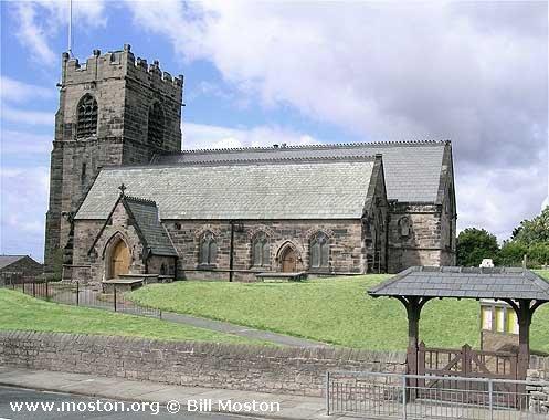
St Oswald, Bidston, Church of England
hide
Hide
Hide
St Oswald,
Bidston Village Road,
Bidston
Hide
Bidston Village Road/School Lane
Church History
An ancient parish church, originally serving the townships of Bidston cum Ford, Moreton, and Saughall Massie, and most of the township of Claughton with Grange. It also included the chapelry of Birkenhead: St. Mary.
The district was affected by the following boundary changes:
- 1864 January 8 — reduced when the townships of Moreton and Saughall Massie were transferred to Moreton: Christ Church.
- 1876 October 31 — reduced when part of the township of Claughton with Grange was transferred to Claughton: Christ Church.
- 1905 May 12 — reduced when the following area was transferred to Birkenhead: St. Anne: "All that portion of the parish of Bidston, in the said county and diocese, which is bounded upon the greater part of the north and upon the east by the said new parish of Saint Anne, Birkenhead, and upon the remaining sides, that is to say, upon the south, upon the west and upon the remaining part of the north, by an imaginary line commencing at the point in the middle of Park-road South where the boundaries of the said new parish of Saint Anne, Birkenhead, the new parish of Saint John, Birkenhead, in the said county and diocese, and the said parish of Bidston all meet, and extending thence westward along the middle of Park-road South (thereby following in part the boundary which divides the new parish of Christ Church, Claughton-cum-Grange, in the said county and diocese, from the said parish of Bidston) for a distance of fifteen chains and a half or thereabouts to its junction with Park-road West, and extending thence north-westward along the middle of Park-road West for a distance of eleven chains and a half or thereabouts to its junction with Ashville-road, and extending thence north-westward and in a straight line (thereby crossing the premises of the house called The Hollies and the public recreation ground called Birkenhead Park and passing through the Norman Lodge entrance to the said recreation ground) for a distance of thirty chains and a half or thereabouts to the junction of Park-road North, Norman-street and Mallaby-street, and extending thence north-eastward along the middle of Mallaby-street for a distance of ten chains or thereabouts to its junction with Brassey-street, and extending thence eastward along the middle of Brassey-street (thereby crossing Laird-street) for a distance of six chains or thereabouts to the point where the boundaries which divide the said parish of Bidston, the new parish of Saint James, Birkenhead, in the said county and diocese, and the said new parish of Saint Anne, Birkenhead, all meet".
- 1905 May 12 — reduced when the following area was transferred to Birkenhead: St. John the Evangelist: "All that portion of the said parish of Bidston which is bounded upon the east by the said new parish of Saint John, Birkenhead, upon the southwest by the said new parish of Christ Church, Claughton-cum-Grange, and upon the remaining side, that is to say, upon the north, by an imaginary line commencing upon the boundary which divides the said new parish of Christ Church, Claughton-cum-Grange, from. the said parish of Bidston at the junction of Slatey-road with Park-road South, and extending thence eastward along the middle of Park-road South for a distance of six chains or thereabouts to the point where the boundaries which divide the said parish of Bidston, the said new parish of Saint Anne, Birkenhead, and the said new parish of Saint John, Birkenhead, all meet."
- 1911 January 24 — reduced when part of the township of Claughton with Grange was transferred to Birkenhead: St. Bede.
- 1957 November 29 — reduced when an area was transferred to Leasowe: St. Chad.
Church Records
C = Christenings (Baptisms) ; M = Marriages ; B = Burials ; BTs = Bishop's Transcripts
| Original Registers | C 1682-1986 ; M 1682-1980 ; B 1679-1958 — Cheshire Archives (P 86) C from 1986 ; M from 1980 ; B from 1958 — Church |
| Microfilm Copies | C 1682-1955 ; M 1682-1958 ; B 1679-1958 — Cheshire Archives C 1682-1862 ; M 1682-1929 ; B 1679-1898 — Manchester Archives & Local Studies ; Birkenhead Central Library |
| Bishop's Transcripts | 1581, 1588, 1596, 1605, 1612, 1614-15, 1617-24, 1632-34, 1636, 1638-39, 1666, 1668-71, 1673, 1675-76, 1679-81, 1683-85, 1687-91, 1694-1701,1704-13, 1715-27, 1729-39, 1741-42, 1745-1843, 1845-63 (microfilmed) — Cheshire Archives ; Family History Society of Cheshire |
| Copies and Indexes | CMB 1581-1700 — published in: The Baptismal, Marriage and Burial Registers of the Parish of Bidston, in the County of Chester, edited by W. F. Irvine (Birkenhead, 1893) CMB 1581-1700 (index by C. Bratt) — Cheshire Archives CMB 1581-1871 — Cheshire Parish Register Project M 1605-1837 (incomplete) — Bertram Merrell Marriage Index of Cheshire (1750-1836) M 1838-1958 — Cheshire BMD (WR:BK1) B 1581-1871 — National Burial Index |
| Monumental Inscriptions | Transcript by C. Bratt — Cheshire Archives Published by the Family History Society of Cheshire (edited by P. E. Turner), 1989 |
It is located at SJ2835590255 (Lat/Lon 53.404232, -3.079112). You can see this on maps provided by:
- OpenStreetMap
- Google Maps
- StreetMap (Current Ordnance Survey maps)
- Bing (was Multimap)
- Old Maps Online
- National Library of Scotland (Old Ordnance Survey maps)
- Vision of Britain (Click "Historical units & statistics" for administrative areas.)
- English Jurisdictions in 1851 (Unfortunately the LDS have removed the facility to enable us to specify a starting location, you will need to search yourself on their map.)
- Magic (Geographic information) (Click + on map if it doesn't show)
- GeoHack (Links to on-line maps and location specific services.)