
Hide
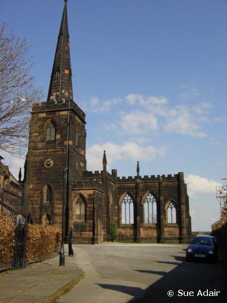
St Mary, Birkenhead, Church of England
hide
Hide
Hide
St Mary,
Church Street,
Birkenhead
Hide
It was founded in 1719. It closed in 1974.
Also known as: Birkenhead Priory.
Church Street/Priory Street
Church History
A parochial chapelry in the parish of Bidston: St. Oswald, originally serving the whole of Birkenhead township.
The district was affected by the following boundary changes:
- 1841 — reduced when part of the township of Birkenhead was transferred to Birkenhead: Holy Trinity.
- 1859 June 9 — reduced when part of the township of Birkenhead was transferred to Birkenhead: St. John the Evangelist.
- 1864 January 14 —reduced when part of the township of Birkenhead was transferred to Birkenhead: St. Paul
- 1869 July 24 — reduced when part of the township of Birkenhead was transferred to Birkenhead: St. James..
- 1881 July 22 — reduced when the following part of the township of Birkenhead was transferred to Birkenhead: St. Paul: "All that contiguous portion-of the said parochial chapelry of Saint Mary Birkenhead which is bounded on the north-east by the River Mersey or in other words by the boundary dividing the said county of Chester from the county of Lancaster, on the west partly by the particular district of the Holy Trinity Birkenhead in the said county of Chester and in the diocese of Chester aforesaid and partly by the said new parish of Saint Paul Birkenhead, on the south by the new parish of Saint Catherine Tranmere aforesaid, and on the remaining side that is to say on the east by an imaginary line commencing upon the boundary which divides the last-named new parish from the parochial chapelry of Saint Mary Birkenhead aforesaid at the point where it is crossed by the line of the Birkenhead and Chester Railway and extending thence north-westward along the middle of the said line of railway for a distance of seventeen chains or thereabouts (following thereby the goods branch of the said railway) to the point at the south-eastern end of the tunnel by which the said goods branch line of railway passes under Grange-lane at its junction with Hamilton-street and extending theme first northward and then north-eastward along the middle of the last-named street for a distance of thirty-eight chains or thereabouts to the point in front of the Woodside Hotel where the said Hamilton-street joins Shore-road at the south-western end of the goods traffic bridge which leads to the landing-stage of the Woodside Ferry aud cont inuing thence still north-eastward along the middle of the said goods traffic bridge for a distance of eleven chains or thereabouts to the said landing-stage and continuing thence in the same direction and in a straight line for a distance of twenty-seven chains or thereabouts to the boundary in the middle of; the River Mersey which divides the said county of Chesler from the county of Lancaster aforesaid"
On 6 August 1948 the district was amalgamated with that of Birkenhead: St. Paul, to form the combined district of "St. Mary and St. Paul". St. Mary's church closed in 1974, and its area became part of a unified Birkenhead district based at Birkenhead: St. Anne.
Church Records
C = Christenings (Baptisms) ; M = Marriages ; B = Burials ; BTs = Bishop's Transcripts
| Original Registers | C 1721-1974 ; M 1721-1974 ; B 1719-1957 — Cheshire Archives (P 70) |
| Microfilm Copies | C 1721-1946 ; M 1721-1965 ; B 1719-1957 — Cheshire Archives ; Birkenhead Central Library
C 1721-1968 ; M 1721-1965 ; B 1719-1957 — Manchester Archives & Local Studies C 1721-1835, 1876-1968 ; M 1721-1965 ; B 1719-1899 — Family History Society of Cheshire |
| Bishop's Transcripts | 1813-1839 (microfilmed) — Cheshire Archives |
| Copies and Indexes | CMB 1719-1812 — published in: The Registers of Births, Deaths and Marriages for the Chapel of: St. Mary's, Birkenhead, edited by F. C. Beazley (1906), and reprinted in Transactions of the Historic Society of Lancashire and Cheshire, vol. 22 (1906)
C 1813-1844 ; B 1813-1837 (microfilmed transcript) — Society of Genealogists' Library M 1719-1788 (transcript) — Society of Genealogists' Library M 1721-1837 (incomplete) — Bertram Merrell Marriage Index of Cheshire (1750-1836) M 1837-1955 — Cheshire BMD (WR:BK8) |
| Monumental Inscriptions | Published by Merseyside Archaeological Society, 1977 (partial])
Transcriipt by B. J. Barnes, 1980 (without index) — Family History Society of Cheshire ; Society of Genealogists' Library |
It was located at SJ3285088544 (Lat/Lon 53.389447, -3.011146). You can see this on maps provided by:
- OpenStreetMap
- Google Maps
- StreetMap (Current Ordnance Survey maps)
- Bing (was Multimap)
- Old Maps Online
- National Library of Scotland (Old Ordnance Survey maps)
- Vision of Britain (Click "Historical units & statistics" for administrative areas.)
- English Jurisdictions in 1851 (Unfortunately the LDS have removed the facility to enable us to specify a starting location, you will need to search yourself on their map.)
- Magic (Geographic information) (Click + on map if it doesn't show)
- GeoHack (Links to on-line maps and location specific services.)