Hide
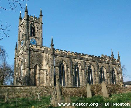
St John the Baptist, Bollington, Church of England
hide
Hide
Hide
St John the Baptist,
Church Street,
Bollington
Hide
It was founded in 1834. It closed in 2003.
Church Street
Church History
Founded in 1834 as a chapel to Prestbury: St. Peter. In 1842 it became the district church for the township of Bollington. The boundaries of "The Chapelry District of Bollington" were described in the London Gazette on 10 May 1842:
"Such district should be named "The Chapelry District of Bollington," which should comprize the township of Bollington, the same being bounded on the north and north west by the township of Adlington ; on the north east by the township of Pott Shrigley ; on the east bv the township ot Rainow; on the south by the townships of Hurdsfield and of Tytherington; and on the west by the township of Butley (all the said townships being in the parish of Prestbury)"
The district was affected by the following boundary changes:
- 1968 November 22 — (details not available)
Closed on 10 June 2004, and succeeded as the district church by Bollington Cross: St. Oswald.
Church Records
C = Christenings (Baptisms) ; M = Marriages ; B = Burials ; BTs = Bishop's Transcripts
| Original Registers | C 1834-1975 ; M 1838-2003 ; B 1835-2004 — Cheshire Archives (P 184) C from 1975 ; M from 1989 ; B from 2004 — held at Bollington Cross: St. Oswald |
| Microfilm Copies | C 1834-1958 ; M 1838-1959 ; B 1835-1937 — Cheshire Archives |
| Bishop's Transcripts | 1834-1840 — included with the BTs of Prestbury: St. Peter 1841-78,1888-93 (microfilmed) — Cheshire Archives ; Family History Society of Cheshire 1856-78,1888-93 (microfilmed) — Macclesfield Library |
| Copies and Indexes | M 1838-2003 — Cheshire BMD (CE:1014) B 1835-1937 — Published by North Cheshire Family History Society |
| Monumental Inscriptions | Published by North Cheshire Family History Society (compiled by the Macclesfield Ferrets, 1987) Online searchable database — see Bollington Cross: St. Oswald Church Website |
- OpenStreetMap
- Google Maps
- StreetMap (Current Ordnance Survey maps)
- Bing (was Multimap)
- Old Maps Online
- National Library of Scotland (Old Ordnance Survey maps)
- Vision of Britain (Click "Historical units & statistics" for administrative areas.)
- English Jurisdictions in 1851 (Unfortunately the LDS have removed the facility to enable us to specify a starting location, you will need to search yourself on their map.)
- Magic (Geographic information) (Click + on map if it doesn't show)
- GeoHack (Links to on-line maps and location specific services.)

