
Hide
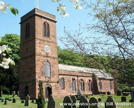
St Nicholas, Burton, Church of England
hide
Hide
Hide
St Nicholas,
The Village,
Burton
Hide
It was founded in 1086.
The Rake
Church History
An ancient parish church, serving the townships of Burton and Puddington.
Church Records
C = Christenings (Baptisms) ; M = Marriages ; B = Burials ; BTs = Bishop's Transcripts
| Original Registers | C 1538-1969 ; M 1538-1997 ; B 1538-1993 — Cheshire Archives (P 54) C from 1969 ; M from 1997 ; B from 1993 — Church |
| Microfilm Copies | C 1538-1969 ; M 1538-1966 ; B 1538-1993 — Cheshire Archives C 1538-1885 ; M 1538-1835 ; B 1538-1897 — Manchester Archives & Local Studies ; Birkenhead Central Library ; Family History Society of Cheshire C 1538-1969 ; M 1538-1835 ; B 1538-1897 — Neston Library |
| Bishop's Transcripts | 1599-1603, 1606-10, 1613-14, 1617-19, 1621-25, 1629-30, 1632, 1634, 1636, 1638, 1642, 1658-60, 1666-76, 1679-85, 1695, 1722, 1724, 1763, 1779-98, 1800-30, 1855-1900 (microfilmed) — Cheshire Archives |
| Copies and Indexes | CMB 1538-1725 — published in F C Beazley, 'Notes on the Parish of Burton in Wirral ', Transactions of the Historic Society of Lancashire and Cheshire, volume 59 (1907) CMB 1538-1871 — Cheshire Parish Register Project M 1722-1837 (incomplete) — Bertram Merrell Marriage Index of Cheshire (1750-1836) M 1841-1958 — Cheshire BMD (CW:CE7) B 1538-1871 — National Burial Index |
It is located at SJ3170474302 (Lat/Lon 53.261301, -3.025302). You can see this on maps provided by:
- OpenStreetMap
- Google Maps
- StreetMap (Current Ordnance Survey maps)
- Bing (was Multimap)
- Old Maps Online
- National Library of Scotland (Old Ordnance Survey maps)
- Vision of Britain (Click "Historical units & statistics" for administrative areas.)
- English Jurisdictions in 1851 (Unfortunately the LDS have removed the facility to enable us to specify a starting location, you will need to search yourself on their map.)
- Magic (Geographic information) (Click + on map if it doesn't show)
- GeoHack (Links to on-line maps and location specific services.)