
Hide
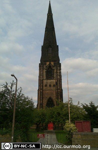
St Matthew, Edgeley, Church of England
hide
Hide
Hide
St Matthew,
Grenville Street,
Edgeley
Hide
It was founded in 1858.
Grenville Street, Edgeley.
Church History
Founded in 1844 as the district church for the hamlet of Edgeley in the township of Cheadle (previously served by Stockport: St. Thomas). The boundaries of "The District of Saint Matthew, Stockport" were described in the London Gazette on 3 June 1844:
"All that part of the district of Saint Thomas, in the said parish and borough of Stockport, bounded by an imaginary line, commencing at a point in the middle of Wellington-road, opposite to the middle of Edward-street, and thence extending eastward along the middle of such lastmentioned street, as far as the middle of the street called the Middle Hillgate, and thence northward, along the middle of such last-mentioned street, to a point opposite to the middle of the street called Cheapside, and thence eastward, 495 feet or thereabouts, along the middle of such last-mentioned street, and thence southward in a straight direction through Carr-dam to Hempshaw-brook, and along the middle of such brook as far as the middle of Hempshaw-lane, and thence westward, along the middle of such lane as far as the middle of the street called the Higher Hillgate, and thence northward along the middle of such last-mentioned street to a point opposite to the middle of Smallstreet, and thence westward along the middle of such last-mentioned street to a point opposite to the middle of Short-street, and thence northward along the middle of such last mentioned street to a point opposite to the middle of Union-street, and thence westward along the middle of such lastmentioned street as far as the middle of Wellington-road aforesaid, and thence northward along the middle of the same road to the point where the said imaginary line commenced."
The district was affected by the following boundary changes:
- 1852 January 9 — enlarged when the hamlet of Brinksway was transferred from Cheadle: St. Mary, and reduced to enlarge the parish of Stockport: St. Mary the Virgin, the revised boundaries being as follows: "The said district shall hereafter consist of and comprise all that portion of the original district situate on the western side of an imaginary line along the middle of Windmill-street, and also all that portion of the township of Stockport, bounded on the north by an imaginary ine commencing at the end of a garden-wall belonging to Mr. Henry Coppock, at the Daw Bank and Edgeley Road ; and thence extending eastward along the middle of Lower Butterworth-street, across land belonging to the Reverend Henry Wright, and a field belonging to Mr. John Thorneley, to the north-western corner of the Stockport railway station; and thence along a road from the railway station to the Wellington turnpike-road, on the east by an imaginary line along the middle of such last-mentioned road, on the south by an imaginary line along the middle of Greek-street and Castle-street, and on the west by the boundary between the parishes of Cheadle and Stockport, and also all that portion of the said parish of Cheadle comprised within the hamlets of Brinksway and Edgeley, in the said parish of Cheadle; all of which is delineated and set forth in the map or plan hereunto annexed, and shall henceforth be the district of Saint Matthew, Stockport ; and that all that portion of the said district as originally constituted, situate on the eastern side of the said imaginary line along the middle of Windmill-street, shall be detached and excluded from the said district, and shall to all intents and purposes again belong to and form part of the said parish of Stockport".
- 1893 November 28 — reduced when parts of the townships of Cheadle Bulkeley and Cheadle Moseley were transferred to Stockport: St. Augustine.
- 1907 April 2 — enlarged by the transfer of the following area from Cheadle: St. Mary: "All that portion of the parish of Cheadle, in the said county and diocese, which is bounded upon the west and upon the north by the said new parish of Saint Matthew, Stockport, and upon the remaining sides, that is to say, upon the east and upon the south, by an imaginary line commencing at the point in the middle of the line of the London and North Western Railway where the boundaries of the said new parish of Saint Matthew, Stockport, the said parish of Cheadle and the parish of Saint Thomas, Stockport, in the said county and diocese, all meet, and extending thence first southward, then south-westward and then westward along the middle of the Warrington and Stockport Line of the said London and North Western Railway for a distance of one mile or thereabouts to the point where the said Warrington and Stockport Line of railway is crossed by the boundary which divides the said parish of Cheadle from the said new parish of Saint Matthew, Stockport."
- 1911 May 5 — reduced when part of Stockport was transferred to Stockport: St. Mark.
Church Records
C = Christenings (Baptisms) ; M = Marriages ; B = Burials ; BTs = Bishop's Transcripts
| Original Registers | C 1858-2006 ; M 1858-2012 — Cheshire Archives (P 276) C from 2006 ; M from 2012 — Church |
| Microfilm Copies | C 1858-1911 ; M 1858-1900 — Stockport Heritage Library |
| Copies and Indexes | M 1858-2012 — Cheshire BMD (ST:17) |
- OpenStreetMap
- Google Maps
- StreetMap (Current Ordnance Survey maps)
- Bing (was Multimap)
- Old Maps Online
- National Library of Scotland (Old Ordnance Survey maps)
- Vision of Britain (Click "Historical units & statistics" for administrative areas.)
- English Jurisdictions in 1851 (Unfortunately the LDS have removed the facility to enable us to specify a starting location, you will need to search yourself on their map.)
- Magic (Geographic information) (Click + on map if it doesn't show)
- GeoHack (Links to on-line maps and location specific services.)