
Hide
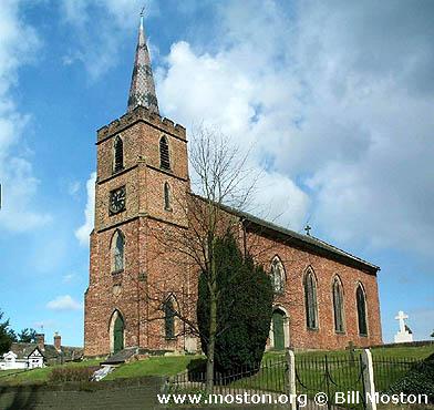
St John the Evangelist, Chelford, Church of England
hide
Hide
Hide
St John the Evangelist,
Holmes Chapel Road,
Chelford
Hide
It was founded in 1679.
Church History
An ancient chapelry in Prestbury: St. Peter parish, serving the townships of Chelford and Old Withington. In 1880 it became a district church and was extended to include part of the township of Snelson (previously served by Over Peover: St. Lawrence. The boundaries of "The Consolidated Chapelry of Saint John the Evangelist Chelford, with Old Withington" were described in the London Gazette on 9 April 1880:
"All those portions of the parish of Prestbury in the county of Chester and in the diocese of Chester which are comprised within and are co-extensive with the limits of the two townships of Chelford and of Old Withington which two said townships have heretofore been held to constitute the ancient chapelry of Chelford and also all that contiguous portion of the ancient chapelry of Over Peover otherwise called Peover Superior in the parish of Rostherne in the county and diocese aforesaid which is comprised within and is coextensive with, the limits of the township of Snelson save, and excepting all that portion of the said lastly-mentioned township which forms the north-western corner thereof and contains by admeasurement forty-nine acres or thereabouts and which is situate to the west and north of an imaginary line commencing upon the boundary which divides the said township of Snelson from the particular district or new parish of Marthall in the county and diocese aforesaid at a point at or near to Snelson House where the road which leads from Merehills turnpike-gate and which is called or known as Pepper-street is joined by the cross road which leads from Snelson House aforesaid into the road which passes along the western side of Highfield Cottage and extending thence that is from Pepper-street aforesaid first south-eastward along the middle of the said cross road for a distance of ten chains or thereabouts (thereby passing along the north-eastern side of the triangular plot or close numbered 55 on the map of the ordnance survey of the said parish of Rostherne on the scale of 1:2500 and upon the map hereto annexed) and then south-westward along the middle of the same cross road for a distance of thirty-four chains or thereabouts (thereby passing along the south-eastern side of the said plot or close) to a point on the western side of Highfield Cottage aforesaid upon the boundary which divides the said township of Snelson from the township of Over Peover otherwise called Peover Superior in the ancient chapelry of Over Peover otherwise called Peover Superior as aforesaid."
The district was affected by the following boundary change:
- 1915 November 30 — enlarged to include the township of Lower Withington from Prestbury: St. Peter.
The district also included the chapel of Lower Withington: St. Peter.
Church Records
C = Christenings (Baptisms) ; M = Marriages ; B = Burials ; BTs = Bishop's Transcripts
| Original Registers | C 1679-2001 ; M 1674-1752 ; B 1675-1894 — Cheshire Archives (P 182) C from 2001 ; M from 1860 ; B from 1894 — Church |
| Microfilm Copies | C 1679-1934 ; M 1674-1752 ; B 1675-1894 — Cheshire Archives C 1679-1849 ; M 1674-1752 ; B 1679-1894 — Manchester Archives & Local Studies ; Family History Society of Cheshire ; Macclesfield Library |
| Bishop's Transcripts | 1691-1700 — included with BTs for Prestbury: St. Peter 1839-1902 (microfilmed) — Cheshire Archives, Family History Society of Cheshire |
| Copies and Indexes | C 1673-1849 ; M 1674-1752 ; B 1674-1894 — North Cheshire Family History Society C 1704-1707, 1771-1794 ; B 1748-1796 (microfilmed transcript) — Society of Genealogists' Library M 1674-1752 — in Cheshire Parish Registers: Marriages, vol. 5 (Phillimore, 1914) M 1674-1752 — Boyd's Marriage Index and North & East Cheshire Marriage Index - may be viewable at subscription sites such as ancestry or findmypast M 1680-1750 (incomplete) — Bertram Merrell Marriage Index of Cheshire (1750-1836) M 1860-1999 — Cheshire BMD (CE:1022) B 1674-1894 — National Burial Index |
| Monumental Inscriptions | Published by Macclesfield Ferrets/Graveyard Press, 1996 |
| Notes | M 1754-1860 — see Prestbury: St. Peter |
- OpenStreetMap
- Google Maps
- StreetMap (Current Ordnance Survey maps)
- Bing (was Multimap)
- Old Maps Online
- National Library of Scotland (Old Ordnance Survey maps)
- Vision of Britain (Click "Historical units & statistics" for administrative areas.)
- English Jurisdictions in 1851 (Unfortunately the LDS have removed the facility to enable us to specify a starting location, you will need to search yourself on their map.)
- Magic (Geographic information) (Click + on map if it doesn't show)
- GeoHack (Links to on-line maps and location specific services.)