
Hide
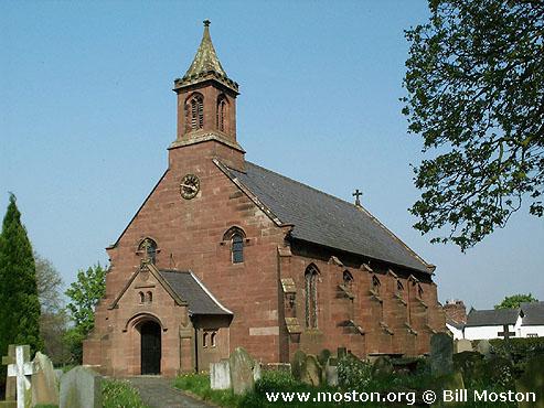
St Mary, Coddington, Church of England
hide
Hide
Hide
St Mary,
Aldersey Lane,
Coddington
Hide
It was founded in 1093.
Church History
An ancient parish church, originally serving the townships of Aldersey, Chowley and Coddington.
The district was affected by the following boundary changes:
- 1963 November 22 — (details not available)
Church Records
C = Christenings (Baptisms) ; M = Marriages ; B = Burials ; BTs = Bishop's Transcripts
| Original Registers | C 1680-1718, 1820-1992 ; M 1680-1718, 1821-1998 ; B 1680-1718, 1820-1992 (P 264) C from 1993 ; M from 1998 ; B from 1993 — Church |
| Microfilm Copies | C 1680-1718, 1820-1992 ; M 1680-1718, 1821-1982 ; B 1680-1718, 1820-1992 — Cheshire Archives ; Family History Society of Cheshire |
| Bishop's Transcripts | 1585, 1599, 1601, 1605-07, 1610, 1614, 1617-18, 1622-27, 1629-31, 1635, 1668-72, 1674-77, 1679-82, 1684-90, 1694, 1696, 1699, 1703, 1709, 1711-19, 1721, 1723-34, 1736-37, 1741-43, 1745-46, 1749, 1751-57, 1759-88,1790-1833, 1840-45, 1854-1900 (microfilmed) ; 1901-03 — Cheshire Archives |
| Copies and Indexes | CMB 1680-1718 (transcript/index) — Cheshire Archives ; Chester Library M 1610-1837 (incomplete) — Bertram Merrell Marriage Index of Cheshire (1750-1836) M 1837-1958 — Cheshire BMD (CW:CE18) |
| Notes | CMB 1718-1820 — destroyed by a fire at the church on 5 May 1820 |
It is located at SJ4531055381 (Lat/Lon 53.092824, -2.81811). You can see this on maps provided by:
- OpenStreetMap
- Google Maps
- StreetMap (Current Ordnance Survey maps)
- Bing (was Multimap)
- Old Maps Online
- National Library of Scotland (Old Ordnance Survey maps)
- Vision of Britain (Click "Historical units & statistics" for administrative areas.)
- English Jurisdictions in 1851 (Unfortunately the LDS have removed the facility to enable us to specify a starting location, you will need to search yourself on their map.)
- Magic (Geographic information) (Click + on map if it doesn't show)
- GeoHack (Links to on-line maps and location specific services.)