
Hide
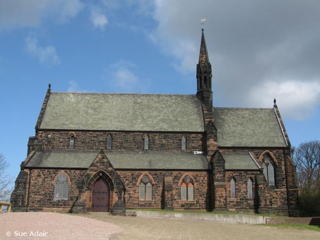
St Mary the Virgin, Halton, Church of England
hide
Hide
Hide
St Mary the Virgin,
Halton
Hide
It was founded in 1732.
Castle Road
Church History
Founded in 1732 as a chapelry in the parish of Runcorn: All Saints, serving the townships of Clifton, Halton, Norton and Stockham, which became a district church. In 1860. The boundaries of "The District Chapelry of Halton" were described in the London Gazette on 16 May 1860:
"All those portions of the parish of Runcorn, in the county and diocese of Chester, which are comprised within the townships of Clifton, Norton, and Stockham. And also all that portion of the township of Halton, in the same parish, which is not included within the particular district of the Holy Trinity, Runcorn."
The district was affected by the following boundary changes:
- 1960 May 20 — enlarged when the following area was transferred from Runcorn: All Saints: "All that detached part of the parish of Runcorn, All Saints, which lies within the boundaries of the parish of Halton".
- 1960 May 20 — enlarged when the following area was transferred from Runcorn: Holy Trinity: "All that part of the parish of Holy Trinity, Runcorn, which lies east of an imaginary line commencing at a point on the boundary which divides the parish of Halton from the parish of Holy Trinity, Runcorn, 3½ chains west df the point where the last mentioned boundary meets the middle olf Latham Avenue and proceeding thence in a straight line due northwards to a point in the middle of Latham Avenue, thence northeastwards in a straight line to tihe boundary which divides the parish of Holy Trinity, Runcom from the parish of Halton at the point where the last mentioned boundary turns from a westerly direction tto a northeasterly direction".
- 1960 May 20 — reduced when the following area was transferred to Runcorn: Holy Trinity: "All that part of the parish of Halton which is bounded on the north by the parish of Holy Trinity, Runcorn, and on the remaining sides by an imaginary line commencing at a point on the boundary which divides the parish of Holy Trinity, Runcorn, from the parish of Halton at the northwestern corner of close numbered 9 (on the map) and proceeding thence southwards along the western boundary of the last mentioned close to ithe point where it meets the northern boundary olf dose numbered 10, thence first westwards then northwestwards along the last mentioned boundary to the boundary which divides the parish of Halton from the parish of Holy Trinity. Runcorn".
- 1960 May 20 — enlarged when the following areas were transferred from Runcorn: St. Michael & All Angels and Runcorn: Holy Trinity: "All those two contiguous parts of the parishes of Saint Michael and All Angels, Runcorn, and Holy Trinity, Runcorn, which, taken together, are bounded on the east by the parish of Halton and on the remaining sides by an imaginary line commencing at a point on the boundary which divides the parish of Saint Michael and All Angels, Runcorn, from the parish of Halton in the middle of the Ditton and Runcorn branch railway line of British Railways (London Midland Region) and proceeding thence northwestwards along the middle of the said railway line to a point in the middle of the bridge which carries Heath Road over the said railway line, thence northeastwards along the middle of Heath Road to a point opposite the middle of line western end of Boston Avenue, thence eastwards in a straight line across close numbered 72 (on the map) to the boundary which divides the parish of Holy Trinity, Runcorn from the parish of Halton at the point where the last mentioned boundary meets the northwestern boundary of close numbered 10".
- 1960 May 20 — reduced when the following area was transferred to Weston by Runcorn: St. John the Evangelist: "All that part of the parish olf Halton which lies to the south and southwest of an imaginary line commencing at a point on the boundary which divides the parish of 'Saint Michael and All Angels, Runcorn, from the parish of Halton in the middle of the Ditton and Runcorn branch railway line of British Railways (London Midland Region) and proceeding thence southeastwards along ithe middle of the said railway line to a point in the middle of its junction with the Frodsham branch railway line of British Railways (London Midland Region), thence southeastwards along the middle of the last mentioned railway line to the boundary which divides the parish of Halton from ithe parish of Aston".
- 1963 May 30 — reduced when part of the civil parish of Runcorn was transferred to Grange: St. Andrew.
In 1973 the district was amalgamated with Runcorn: Holy Trinity and Grange: St. Andrew to create the combined district of "East Runcorn with Halton".
The district also included the subsidiary churches of Castlefields: Christ Church, Norton: St. Bertoline & St. Christopher, and Hallwood: St. Mark.
Church Records
C = Christenings (Baptisms) ; M = Marriages ; B = Burials ; BTs = Bishop's Transcripts
| Original Registers | C 1732-1986 ; M 1733-1749, 1860-2006 — Cheshire Archives (P 27) C from 1986 ; M from 2006 — Church |
| Microfilm Copies | C 1732-1940 ; M 1733-1749, 1860-1936 — Cheshire Archives ; Manchester Archives & Local Studies ; Family History Society of Cheshire C 1732-1940 ; M 1733-1749, 1860-1957 — Halton Lea Library |
| Bishop's Transcripts | 1732-39, 1741-1841, 1843-45, 1851-87 (microfilmed) — Cheshire Archives |
| Copies and Indexes | M 1860-1951 — Cheshire BMD (HA:C15) |
| Notes | M 1738-1746 — omitted from registers M 1759-1860 — see Runcorn: All Saints B — none |
- OpenStreetMap
- Google Maps
- StreetMap (Current Ordnance Survey maps)
- Bing (was Multimap)
- Old Maps Online
- National Library of Scotland (Old Ordnance Survey maps)
- Vision of Britain (Click "Historical units & statistics" for administrative areas.)
- English Jurisdictions in 1851 (Unfortunately the LDS have removed the facility to enable us to specify a starting location, you will need to search yourself on their map.)
- Magic (Geographic information) (Click + on map if it doesn't show)
- GeoHack (Links to on-line maps and location specific services.)