
Hide
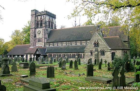
St John the Baptist, Hartford, Church of England
hide
Hide
Hide
St John the Baptist,
The Green,
Hartford
Hide
It was founded in 1824.
Chester Road
Church History
Founded in 1825 as a chapel to Witton: St. Helen. In 1863 it became the district church for the township of Hartford, and part of the township of Winnington (previously served by Witton: St. Helen). The boundaries of "The District Chapelry of Saint John, Hartford" were described in the London Gazette on 15 September 1863:
"All that portion of the parochial chapelry of Witton-cum-Twambrooks, within the parish of Great Budworth, in the county of Chester, and in the diocese of Chester, which is comprised within that part of the township of Hartford, which is situate within the said parish of Great Budworth, and also all that portion.of the said parochial chapelry within the same parish, which is comprised within so much of the township of Winnington, as is situate to the south east of an imaginary line, commencing upon the boundary dividing the said parochial chapelry from the parish of Weaverham, in the same county and diocese, at a point on the western side of the road leading from Hartford to Winnington, opposite to a boundary stone inscribed 'H. St. J. D.. C. 1863,' and placed on the eastern side of such road at the south-western extremity of the fence dividing the close numbered 30A, upon the tithe commutation map of the said township of Winnington, and upon the map hereunto annexed from the close numbered 27, upon the same maps, and extending thence in a direct line north-eastward across the said road to the said boundary stone, and continuing thence in the same direction along the. middle of the said fence, and of the fences dividing the closes numbered respectively 30, 34, 35, 38, and 37, upon the said maps, from the closes numbered respectively 27 as aforesaid, 39, 40, and 41, upon the same maps, to the boundary dividing the said township of Winnington and the said parochial chapelry of Witton-cum-Twambrooks from a detached portion of the parish of Weaverham aforesaid, at the eastern extremity of the fence which divides the close numbered 37, from the close numbered 41, upon the before-mentioned maps."
The district was affected by the following boundary alterations:
- 1929 March 26 — reduced when part of the township of Hartford was transferred to Northwich: Holy Trinity.
- 1936 July 17 — enlarged to include three detached portions from Weaverham: St. Mary.
Church Records
C = Christenings (Baptisms) ; M = Marriages ; B = Burials ; BTs = Bishop's Transcripts
| Original Registers | C 1845-1996 ; M 1837-1943 ; B 1826-1896 — Cheshire Archives (P 2) C from 1996 ; M from 1943 ; B from 1896 — Church |
| Microfilm Copies | C 1845-1941 ; M 1837-1943 — Cheshire Archives ; Northwich Library |
| Copies and Indexes | M 1837-1974 — Cheshire BMD (CW:127) |
| Monumental Inscriptions | Published by the Family History Society of Cheshire, 1992 |
- OpenStreetMap
- Google Maps
- StreetMap (Current Ordnance Survey maps)
- Bing (was Multimap)
- Old Maps Online
- National Library of Scotland (Old Ordnance Survey maps)
- Vision of Britain (Click "Historical units & statistics" for administrative areas.)
- English Jurisdictions in 1851 (Unfortunately the LDS have removed the facility to enable us to specify a starting location, you will need to search yourself on their map.)
- Magic (Geographic information) (Click + on map if it doesn't show)
- GeoHack (Links to on-line maps and location specific services.)