
Hide
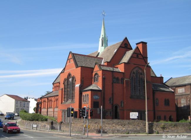
St Luke, Poulton, Church of England
hide
Hide
Hide
St Luke,
Breck Road/Mill Lane,
Poulton
Hide
It was founded in 1907.
Breck Road/Mill Lane.
Church History
Built in 1907 as the district church for parts of the townships of Poulton cum Seacombe and Wallasey (previously in the parish of Wallasey: St. Hilary). The boundaries of "The District Chapelry of Saint Luke, Poulton" were described in the London Gazette on 19 February 1907:
"All that part of the parish of Wallasey, in the county of Chester, and in the diocese of Chester, which is bounded upon the north-east partly by the new parish of Saint Mary, Liscard, and. partly by the new parish of Saint John, Egremont, otherwise Liscard, upon the east by the new parish of Saint Paul, Seacombe, upon the south by the new parish of Saint Anne, Birkenhead, upon the south-west partly by the new parish of Saint James, Birkenhead, and partly by the parish of Bidston, all in the said county and diocese, and upon the remaining side, that is to say, upon the north-west, by an imaginary line commencing at a point in the middle of Wallasey Pool where the boundary which divides the said parish of Bidston from the said parish of Wallasey is crossed by the line of the Wirral Railway, and extending thence south-eastward along the middle of the said line of railway for a distance of twenty chains, or thereabouts, to a point where such line of railway crosses the boundary which divides the civil parish of Wallasey from the civil parish of Poulton-cum-Seacombe, and extending thence first north-westward, then north-eastward, theu south-eastward, and then again north-eastward along the said civil parish boundary for a distance of twenty-four chains and a h a l f, or thereabouts, to the junction of Mill-lane with Marlowe-road, and extending thence northwestward along the Middle of Marlowe-road for a distance of five chains and a half precisely, and extending thence north-eastward in a line parallel with Mill-lane (thereby including the Model Farm) for a distance of thirteen chains, or thereabouts, to the boundary which divides the said parish of Wallasey from the said new parish of Saint Mary, Liscard."
Church Records
C = Christenings (Baptisms) ; M = Marriages ; B = Burials ; BTs = Bishop's Transcripts
| Original Registers | C 1907-1964 ; M 1907-1980 — Cheshire Archives (P 327) C from 1964 ; M from 1980 — Church |
| Copies and Indexes | M 1907-1937 — Cheshire BMD (WR:C9) |
It is located at SJ3016291116 (Lat/Lon 53.412213, -3.052127). You can see this on maps provided by:
- OpenStreetMap
- Google Maps
- StreetMap (Current Ordnance Survey maps)
- Bing (was Multimap)
- Old Maps Online
- National Library of Scotland (Old Ordnance Survey maps)
- Vision of Britain (Click "Historical units & statistics" for administrative areas.)
- English Jurisdictions in 1851 (Unfortunately the LDS have removed the facility to enable us to specify a starting location, you will need to search yourself on their map.)
- Magic (Geographic information) (Click + on map if it doesn't show)
- GeoHack (Links to on-line maps and location specific services.)