
Hide
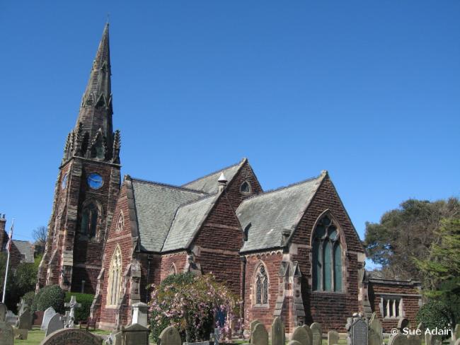
All Saints, Thornton Hough, Church of England
hide
Hide
Hide
All Saints,
Church Road,
Thornton Hough
Hide
It was founded in 1868.
Raby Road.
Church History
Founded in 1869 as the district church for the townships of Brimstage and Thornton Hough, and parts of the townships of Little Neston and Raby (previously served by Willaston: Christ Church and Bromborough: St. Barnabas). The boundaries of "The Consolidated Chapelry of All Saints, Thornton Hough" were described in the London Gazette on 15 January 1869:
"All that portion of the new parish of Willaston, in the county of Chester, and in the diocese of Chester, which comprises the whole of the township of Thornton Hough, and parts of the townships of Raby and Neston, all which said portion of such new parish is situate to the northwest of an imaginary line commencing upon the boundary which divides the same new parish from the parish of Neston, in the said county and diocese, at the point where the turnpike road, leading from Chester to Thurstaston, is joined by the cross road leading from Neston, past Upland House and Willowbrow into the road that leads from Willaston to Four Lanes End ; and extending thence, north-eastward, along the middle of the said cross road to its junction with the said road leading from Willaston to Four Lanes End ; and extending thence, northward, along the middle of the last described road to its unction at Four Lanes End aforesaid, with the road leading from Raby, past Raby Watermill, to Poolton; and extending thence north-eastward, along the middle of the last described road to the boundary at or near Raby Watermill aforesaid, which divides the said new parish of Willaston from the parish of Bromborough, in the county and diocese aforesaid."
"And also all that contiguous portion of the said parish of Bromborough, situate to the north of Thornton Hough, which is comprised within, and is co-extensive with, the limits of the township of Brimstage."
The district was affected by the following boundary change:
- 1905 May 30 — enlarged when the following area was transferred from Willaston: Christ Church: "All that portion of the said new parish of Willaston which is bounded upon the south-east by the parish of Eastham upon the north-east partly by the last-named parish and partly by the parish of Bromborough, upon the north by the parish of Bebington, all in the said county and diocese, upon, the north-west and upon the greater part of the west, by the said new parish of All Saints, Thornton Hough, and upon the remaining sides, that is to say, upon the remaining part of the west and upon the south, by an imaginary line commencing upon the boundary which divides the said new parish of All Saints, Thornton Hough, from the said new parish of Willaston, at the junction of the road leading from Raby and Willowbrow Farmhouse with the road leading from Four Lanes End to Willaston, and extending thence southward along the middle of the last-mentioned road for a distance of five chains or thereabouts to its junction with the road which leads past the houses known as Rabyhouse, Rabyhouse Farm and Hargrave Hall, to Hooton, and extending thence first eastward and then south-eastward along the middle of the last-mentioned road for a distance of one mile and thirty-two chains or thereabouts to the boundary which divides the said new parish of Willaston from the said parish of Eastham"
Church Records
C = Christenings (Baptisms) ; M = Marriages ; B = Burials ; BTs = Bishop's Transcripts
| Original Registers | C 1868-1902 — Cheshire Archives (P 179) C from 1902 ; M from 1869 ; B from 1865 — Church |
| Bishop's Transcripts | 1868-1877 (microfilmed) — Cheshire Archives |
| Copies and Indexes | C 1868-1998 (index by R. Mosedale) — Cheshire Archives M 1869-1974 — Cheshire BMD (WR:BK63) M 1869-2000 (index by R. Mosedale, 2 vols.) — Cheshire Archives B 1868-1997 (transcript/index, 2 vols.) — Cheshire Archives |
| Monumental Inscriptions | Transcript (including B 1868-1997) — Cheshire Archives |
- OpenStreetMap
- Google Maps
- StreetMap (Current Ordnance Survey maps)
- Bing (was Multimap)
- Old Maps Online
- National Library of Scotland (Old Ordnance Survey maps)
- Vision of Britain (Click "Historical units & statistics" for administrative areas.)
- English Jurisdictions in 1851 (Unfortunately the LDS have removed the facility to enable us to specify a starting location, you will need to search yourself on their map.)
- Magic (Geographic information) (Click + on map if it doesn't show)
- GeoHack (Links to on-line maps and location specific services.)