
Hide
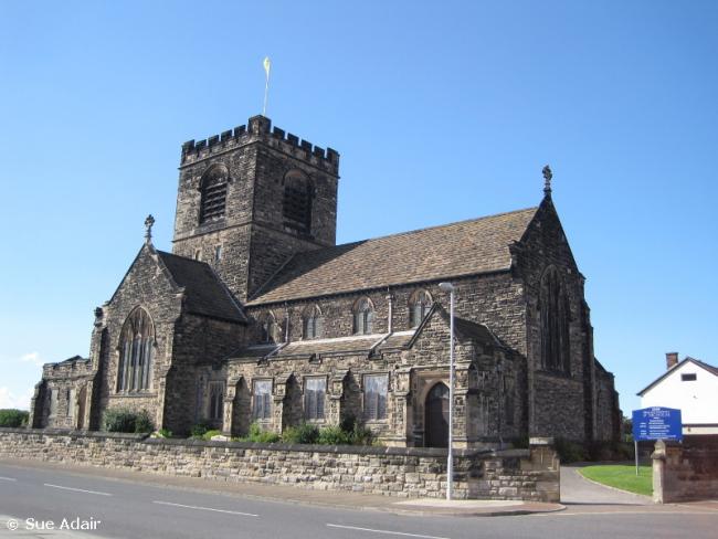
St Nicholas, Wallasey, Church of England
hide
Hide
Hide
St Nicholas,
Newport Avenue/Bayswater Road,
Wallasey
Hide
It was founded in 1911.
Newport Avenue/Bayswater Road
Church History
From 1912 the district church for part of the township of Wallasey. The boundaries of "The District Chapelry of Saint Nicholas, Wallasey" were described in the London Gazette on 23 January 1912:
"All that part of the parish of Wallasey, in the county of Chester and in the diocese of Chester, which is bounded upon part of the south partly by the parish of Bidston and partly by the new parish of Christ Church, Moreton, upon the west by the new parish of the Holy Trinity in Hoose, commonly known as the Holy Trinity, Hoylake, all in the said county and diocese, upon the northwest by the sea, upon the east by the new parish of Saint James, New Brighton, in the said county and diocese, and upon the remaining sides, that is to say, upon the south-east and upon the remaining part of the south, by an imaginary line commencing upon the boundary which divides the said new parish of Saint James, New Brighton, from the said parish of Wallasey, at the junction of Grove Road with the road called Rolleston Drive, and extending thence south-eastward along the middle of Rolleston Drive for a distance of seven chains and three-quarters or thereabouts to its junction with Lyndhurst Road, and extending thence south-westward along the middle of Lyndhurst Road for a distance of ten chains and a-half or thereabouts to its junction with Claremount Road, and extending thence southward along the middle of Claremount Road for a distance of eight chains or thereabouts to its junction with Sandy Lane, and extending thence westward along the middle of Sandy Lane for a distance of twenty-one chains and three-quarters or thereabouts to its junction with Village Street, and extending thence south-eastward along the middle of Village Street for a distance of eighteen chains or thereabouts to its junction with Leasowe Road, and extending thence south-westward along the middle of Leasowe Road for a distance of one mile and twenty-three chains or thereabouts to the boundary which divides the said parish of Wallasey from the said parish of Bidston."
The district was affected by the following boundary changes:
- 1957 November 29 — reduced when an area was transferred to Leasowe: St. Chad.
Church Records
C = Christenings (Baptisms) ; M = Marriages ; B = Burials ; BTs = Bishop's Transcripts
| Original Registers | C 1911-1963 ; M 1912-2000 — Cheshire Archives (P 267) C from 1963 ; M from 2000 — Church |
| Microfilm Copies | C 1912-1926 — Cheshire Archives |
| Copies and Indexes | M 1912-1938 — Cheshire BMD (WR:C12) |
- OpenStreetMap
- Google Maps
- StreetMap (Current Ordnance Survey maps)
- Bing (was Multimap)
- Old Maps Online
- National Library of Scotland (Old Ordnance Survey maps)
- Vision of Britain (Click "Historical units & statistics" for administrative areas.)
- English Jurisdictions in 1851 (Unfortunately the LDS have removed the facility to enable us to specify a starting location, you will need to search yourself on their map.)
- Magic (Geographic information) (Click + on map if it doesn't show)
- GeoHack (Links to on-line maps and location specific services.)