
Hide
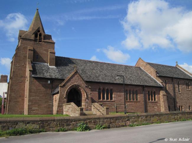
St John the Evangelist, Weston (near Runcorn), Church of England
hide
Hide
Hide
St John the Evangelist,
Weston Road/Heath Road South,
Weston (near Runcorn)
Hide
It was founded in 1889.
Weston Village.
Church History
Built in 1898 as a chapel to Runcorn: All Saints. In 1930 it became the district church for the township of Weston and part of the township of Runcorn (previously served by Runcorn: All Saints). The boundaries of the district were descried in the London Gazette on 16 May 1930:
"All that part of the Parish of Runcorn, in the County of Chester and in the Diocese of Chester, which is bounded upon the west by the River Mersey, upon the south by the Parish of Frodsham, upon the east by the New Parish of Halton, both in the said County and Diocese, and upon the remaining sides, that is to say, upon the north east and upon the north, by an imaginary line commencing at the point where the boundary which divides the said New Parish of Halton from the said Parish of Runcorn crosses the middle of the road leading from Clifton to Higher Runcorn, and extending thence north westward along the middle of the said road for a distance of 30 chains or thereabouts to a, point opposite to the south eastern end of the wall or fence forming the south western boundary of Runcorn Heath, and extending thence first westward to and then first north westward and then in various directions along such wall or fence and across Heath Road for a distance in all of 35 chains or thereabouts to the point where such wall or fence reaches the eastern side of the road leading along the western side of Runcorn Heath, to Higher Runcorn, and extending thence north westward in a straight line (thereby crossing Beacon Hill) for a distance of 25½ chains or thereabouts to the south eastern corner of the premises attached to the house known as Beaconsfield House, and extending thence first westward along the wall or fence forming the southern boundary of such premises and then northward along the wall or fence forming the western boundary of the same premises for a distance in all of 7 chains or thereabouts to the point where the last mentioned wall or fence meets the fence forming the southern boundary of the close numbered 1 upon the map or plan annexed to this Representation, and extending thence westward along the last mentioned fence and along the fence forming the southern boundary of the close numbered 2 upon the said map or plan for a distance in all of 12¾ chains or thereabouts to the point where the last mentioned fence reaches the eastern side of the roadway leading northward into Cock and Hen Lane, and extending thence first westward to and then northward along the middle of the said roadway for a distance in all of 6½ chains or thereabouts to its junction with Cock and Hen Lane, and extending thence westward along the middle of Cock and Hen Lane for a distance of 6 chains or thereabouts to its junction with the roadway leading under the Runcorn Dock Branch Line of the London, Midland and Scottish Railway to the Runcorn and Weston Canal, and extending thence first north westward and then south westward along such roadway for a distance of 15 chains or thereabouts to its junction with the towing path on the eastern side of the said canal, and extending thence in a straight line due west (thereby crossing the said Runcorn and Weston Canal and the Manchester Ship Canal) to the boundary of the said Parish of Runcorn in the River Mersey"
The district was affected by the following boundary changes:
- 1960 May 20 — enlarged when the following area was transferred from Halton: St. Mary the Virgin: "All that part of the parish olf Halton which lies to the south and southwest of an imaginary line commencing at a point on the boundary which divides the parish of 'Saint Michael and All Angels, Runcorn, from the parish of Halton in the middle of the Ditton and Runcorn branch railway line of British Railways (London Midland Region) and proceeding thence southeastwards along ithe middle of the said railway line to a point in the middle of its junction with the Frodsham branch railway line of (British Railways (London Midland Region), thence southeastwards along the middle of the last mentioned railway line to the boundary which divides the parish of Halton from ithe parish of Aston".
Church Records
C = Christenings (Baptisms) ; M = Marriages ; B = Burials ; BTs = Bishop's Transcripts
| Original Registers | C 1914-1954 ; M 1924-1980 — Cheshire Archives (P 116) C from 1954 ; M from 1980 — Church |
| Microfilm Copies | C 1914-1954 ; M 1924-1952 — Cheshire Archives |
| Copies and Indexes | M 1924-1951 — Cheshire BMD (CC:C16) |
| Notes | C 1898-1914 — recorded at Runcorn: All Saints |
It is located at SJ5088680455 (Lat/Lon 53.318731, -2.738733). You can see this on maps provided by:
- OpenStreetMap
- Google Maps
- StreetMap (Current Ordnance Survey maps)
- Bing (was Multimap)
- Old Maps Online
- National Library of Scotland (Old Ordnance Survey maps)
- Vision of Britain (Click "Historical units & statistics" for administrative areas.)
- English Jurisdictions in 1851 (Unfortunately the LDS have removed the facility to enable us to specify a starting location, you will need to search yourself on their map.)
- Magic (Geographic information) (Click + on map if it doesn't show)
- GeoHack (Links to on-line maps and location specific services.)