
Hide
Bewcastle
hide
Hide
hide
Hide
hide
Hide
Hide
"This extensive parish, comprehending over 80,000 acres, lies partly between two branches of the River Lyne, called the Black and White Lyne, and is bounded on the north by Nichol Forest and Scotland; on the west by Stapleton parish; on the south by Lanercost, and on the east by Northumberland. It comprises the townships of Bewcastle, Bailey, Bellbank, and Nixons, containing 26,645 acres of land subject to assessment, of which the rateable value is £11,590 17s." [Description from T. Bulmer & Co's History, Topography and Directory of East Cumberland, 1884]
Hide
- Well, there are no public archives or libraries within Bewcastle parish. It is, though, quite well documented, a benefit of the location and its consequences over the centuries. Information on County Record Offices and Libraries generally may be found on our Cumberland Archives and Libraries web page. Additional records are at the University of Durham - Library Archives and Special Collections.
- The Tullie House is a museum and art gallery with an emphasis on the area's Roman and turbulent border history. If your family was involved with the reivers, its worth a visit; and if you have Bewcastle ancestors, they were involved!
Tullie House Museum
It's immediately across from the Castle and they also have a postal research service which seems to specialize in researching reivers and outlaws.
Castle Street
Carlisle, Cumbria CA3 8TP
- Recent publications on the Bewcastle village website (archived copy), and some other information on our Bewcastle Heritage Society page.
- Listed here are several valuable sources not believed to be generally available or currently in print. Copies may, however, be occasionally found at used book sellers or through book search agents. All are believed to be on hand at the Carlisle Public Library and/or at the County Record Office at the Carlisle Castle.
- History, Topography and Directory of East Cumberland, T.F. Bulmer, T.Bulmer & Co., Manchester, 1884. Bulmer published a series of directories; the 1884 edition being the one Don has. These contain rather extensive information on the various parishes, towns, and a listing of the inhabitants, their residence and occupation. A good place to start in learning about the parish.
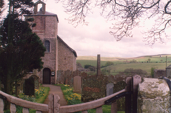
- Transactions of the Cumberland and Westmoreland Antiquarian & Archaeological Society, Volume II, New Series, 1902, W.G. Collingwood, Ed., the Society, Kendal, 1902. This volume of the series offers an excellent article on the history of the Church of England 's St. Cuthbert's Church, Bewcastle, by J.F. Curwen, beginning on page 242 and featuring two high quality photographs of the early church.
- The Roman Bath-House at Bewcastle, Cumbria, Gilliam, Jobey & Welsby, Cumberland and Westmoreland Antiquarian & Archaeological Society Research Series Number 7, the Society, Avon, 1993. ISBN 1 873124 17 1. This work documents the findings of several excavations at the site of the Roman fort which is located under St. Cuthbert's church and extending onto the neighboring farm (presently owned by Graham Noble, a cousin, incidentally). Although it concentrates on the bath-house portion of the fort and records some extreme detail, it offers a few excellent photographs including a very interesting aerial view on the cover.
- Shielings and Bastles, Ramm, McDowall, & Mercer, Royal Commission on Historical Monuments (England), H.M.S.O., London, 1970. Shielings were small dwellings constructed within the common grazing land for use by shepherds while away from their homes. Bastles were relatively small, fortified dwellings for the defense of a family and livestock. This work attempts an inventory of ruins from dwellings of these types and can provide the location and bits of information concerning long abandoned farms mentioned in the early records. Very good photographs and maps.
- An index to the Monuments of St Cuthbert's Churchyard, Bewcastle (generally covering inscriptions prior to 1855 - archived copy) is available on the Bewcastle Village website. A full typescript of the Inscriptions and Graveyard Census is also available at the Carlisle Record Office.
The 14th century through the 17th century was a period of great unrest, and the border between England and Scotland was a turbulent place, with Bewcastle at the hub. As a result, the parish was several times laid waste and little information about a church survives. A church rector is recorded in the early 1300's with several successors, but the record is then lost until about 1580. The ancient chalice of the church is dated 1630 and survives today. In 1597, the church was said to be "decayed for over sixty years and the patron unknown" and its condition had not improved by a Crown survey in 1604. The rector recorded it as in good repair in 1687, but in 1703, Bishop Nicholson of Carlisle wrote of its poor condition, noting that "The font wants a pedestal and looks like a swine's trough." and "...no bell to call them into divine service." A visitor in 1753 noted much improvement since the Bishop's visit, but a bell was not purchased until 1785. The church was remodelled in 1792 and significant repairs made in 1879, but by 1899 surveyors found that not only was the church in a bad state of repair, it was dangerous. Major work commenced in 1901 and the church reopened on Sunday, 3d November of that year.
The original records and bishops transcripts are held in Carlisle RO, but readers can only access registers on microfilm.
The reference number links to the CASCat catalogue listing for all records for the parish.
| Parish | Church | CASCAT ref | Baptisms | Marriages | Burials | Banns | BTs | IGI Batch search | FamilySearch Wiki |
| Bewcastle | St Cuthbert | PR53 | 1737-1900 | 1738-1977 | 1754-2001 | 1737-1966 | 1665-1894 | Bewcastle | Bewcastle |
| Bewcastle | Presbyterian | 1788-1997 | Carlisle |
IGI batch numbers are those compiled by Hugh Wallis on Rootsweb (Hugh Wallis) that can be used to search directly in FamilySearch.
Alternatively try the Archers Software interface
Transcripts of the records from 1665 through 1812, fully indexed, are available; Knowe Chapel, Bewcastle The registers of the Knowe Presbyterian church are in two parts. Part one dates from the church's founding in 1788 through 1838 and part two, from 1839 on. The original of part one is held at the PRO, Chancery Lane, London, but a microfilm copy is held by the Cumbria Record Office in Carlisle. An edited version of part one was made in 1853, entitled: Register of Names Selected From the Copy of the Register of Baptisms, Number 1 (kept by Revd. William Tweedie at Knowe Manse in 1853) of Persons Baptized who have Emigrated to America and Other Parts of the World, and Some Other Persons. This is kept by the CRO, Ref.: DX/170/3 . The entire Knowe registers, 1788 through 1994, have been transcribed, indexed, and the information from the 1853 supplement incorporated.
- Civil registrations for Bewcastle were originally recorded at Longtown. These records are presently at the Carlisle District. Additional details of this registration district are available.
- A detailed description of Bewcastle may be found in Bulmer's 1884 Directory of East Cumberland (cited above). Our own description is organized to allow you to more quickly find specific information to aid your research, but it is hoped, and strongly recommended, that you read the short history presented here as well and dig a bit deeper once you're hooked. So take a look at Bewcastle from here; and if you're in the north of England, a visit is tremendously enhanced by a bit of homework and things are far easier to find with the aid of one of the Ordnance Survey maps, either the Landranger 86 or the more detailed Pathfinder 532. Take a jacket, and a lunch.
[Don Noble, 1996]
- A Description of Bewcastle transcribed from T. Bulmer & Co's History, Topography and Directory of East Cumberland, 1884 by Don Noble.
- The transcription of the section for Bewcastle from the National Gazetteer (1868) provided by Colin Hinson.
- Ask for a calculation of the distance from Bewcastle to another place.
- Few, if any, modern roadmaps will show any reference to Bewcastle as it is not on any modern highway. In earlier times, however, it was the parish's location astride the highways of the times that led to its fascinating history. To the Romans, it was on the way to the Land of the Picts, or rather on the way from there, a route for attackers approaching Hadrian's Wall and a site apparently worth defending with a major fort. After the Norman conquest, and until the union of the Kingdom's, Bewcastle was the route of many armies and bands of marauding reivers. Bewcastle was important by an accident of geography, but that leaves us, today, with more records, and far more lively tales, than if the parish was in some more pastoral spot.
- Why the Romans built a major camp and fort at Bewcastle remains a mystery. Hadrian's Wall is a few miles south; that is, Bewcastle is beyond the Wall, well into the area the Wall was to defend against. In the first military plan for the Wall, infantry was garrisoned in a series of forts along the Wall, which formed a classic defence across Britain at its narrowest point. The Roman's second military plan for the Wall was more sophisticated, using cavalry to ride out and conduct the fight in front of the Wall. Two outposts, other than Bewcastle, were built to the north but these commanded good ground and offered superior visibility. The fort built at Bewcastle lacks any apparent military justification, lying almost in a valley, not on a likely invasion route, and unable to see the signal fires of other posts. The design of the fort breaks the most fundamental rules of Roman practice. It is neither square nor rectangular, but has six sides and internally, the standard layout of a Roman camp is ignored. The ancient road called the Maiden Way passes near Bewcastle and may have been one of the few routes into the north capable of passing wheeled carts, even before the Romans arrived in about A.D. 79. Perhaps this was the site of an earlier British encampment and thus influenced the choice by the Romans. The Romans abandoned the fort by A.D. 367 and the Angles entered the area, presumably occupying the Roman facilities. That Bewcastle was of some significance to them is evidenced by the presence, to this day, of the Bewcastle Cross, believed to mark the burial place of the Anglian King, Alcfrith, and erected in the seventh or eighth century. It sits in the churchyard of the present parish church, both lying within the walls of the earlier Roman fort.View full size (182K)
Bewcastle Cross
You can see maps centred on OS grid reference NY566746 (Lat/Lon: 55.063966, -2.681061), Bewcastle which are provided by:
- OpenStreetMap
- Google Maps
- StreetMap (Current Ordnance Survey maps)
- Bing (was Multimap)
- Old Maps Online
- National Library of Scotland (Old Ordnance Survey maps)
- Vision of Britain (Click "Historical units & statistics" for administrative areas.)
- English Jurisdictions in 1851 (Unfortunately the LDS have removed the facility to enable us to specify a starting location, you will need to search yourself on their map.)
- Magic (Geographic information) (Click + on map if it doesn't show)
- GeoHack (Links to on-line maps and location specific services.)
- All places within the same township/parish shown on an Openstreetmap map.
- Nearby townships/parishes shown on an Openstreetmap map.
- Nearby places shown on an Openstreetmap map.
- At the time of the Conquest in 1066, the Bewcastle area was in the hands of a powerful Saxon, one Bueth; "He builded Bew castle and was Lord of Buecastle Dale". It is from Bueth that the parish name is derived. Gilles Bueth, for having sided with the Scot's, was forced to flee to Scotland and his lands given by Henry II to Herbert de Vallibus in 1157. From the 14th century through the 17th century the border between England and Scotland was a turbulent place, with reiving, or banditry, reaching its peak in the mid 1500's. Bewcastle was the hub of reiving activity, with many routes crossing the parish. Large bands of reivers, often aligned along family lines, carried out bloodthirsty raids in which victim's homes were burned and they lost their cattle, possessions, and sometimes their lives. In 1582, Thomas Musgrave, Captain of Bewcastle, and his tennants lost 700 cattle, 300 sheep and building and crops which were burned. The total value of the loss was £10,000! The stories of these raids, and the sorrows, have come down to us in the Border Ballads." After the Conquest, reportedly ca. 1092, a 'modern' stone castle was erected on the site of the former Roman fort. With the permission of the author Mike Jackson, a detailed description of Bewcastle Castle is available as an extract from his book Castles of Cumbria. In 1641, the castle, having been garrisoned by supporters of the King was destroyed, tradition has it, by Cromwell's forces placing cannon on a nearby hill and bombarding the structure until only two wall partially remained. Today, the ruins stand on Graham Noble's Demense farm, inhabited by sheep and cattle.
- Bewcastle fell under the authority of the ancient diocese of Carlisle and wills prior to 1858 were proved in the consistory court there. Records from 1548 to 1858 include original wills, letters of administration and inventories, although there are significant gaps in the years before 1661. These are deposited with the CRO at Carlisle. Comprehensive indexes exist, at the Carlisle CRO, in card files easily accessible in the reading room. The indexes cover from 1617 to 1941, listing the year of probate and the residence of the deceased. This is extraordinarily helpful in distinguishing between many individuals of the same name. Microfilm of many of these records, and a partial typescript of the indexes, is available at the Kendal office of the CRO.
- The Province of York covered most of northern England, including Bewcastle, and anyone who died leaving property in more than one diocese within the province would have their will proved in the Prerogative Court of the Archbishop of York (PCY) or sometimes in the Chancery Court of the Archbishop of York. These records are now deposited with York University, Borthwick Institute of Historical Research.
- For probate from 1858 on, and general information, see our England - Probate page. However please note registered copy probate records for Cumberland are also available 1858-1941 at the Record Office in Carlisle.
- Information provided by GENUKI about the Bewcastle Heritage Society.
- If you're researching ancestors in the area, consider joining the Cumbria Family History Society.
- Information provided by GENUKI about the Bewcastle Heritage Society.
- If you're researching ancestors in the area, consider joining the Cumbria Family History Society.