
Hide
St Buryan
hide
Hide
hide
- Archives & Libraries◬
- Bibliography◬
- Cemeteries
- Census
- Chronology◬
- Church History
- Church Records
- Churches
- Civil Registration
- Correctional Institutions◬
- Court Records◬
- Description & Travel
- Directories
- Emigration & Immigration◬
- Folklore◬
- Gazetteers
- Genealogy
- Handwriting◬
- Heraldry◬
- Historical Geography
- History◬
- Jewish History◬
- Land & Property◬
- Language & Languages◬
Hide
hide
Hide
Hide
hide
- Manors
- Maps
- Medical Records◬
- Merchant Marine◬
- Military History◬
- Military Records◬
- Names, Geographical◬
- Names, Personal◬
- Newspapers◬
- Nobility◬
- Occupations
- Officials & Employees◬
- Periodicals◬
- Politics & Government◬
- Poor Houses, Poor Law
- Population
- Probate Records◬
- Public Records◬
- Religion & Religious Life
- Schools◬
- Social Life & Customs◬
- Societies
- Statistics
- Visitations, Heraldic◬
Hide
St Buryan (or Buryan), (Cornish: Eglosveryan), is in the Deanery and Hundred of Penwith. It is in the Land's End district and is located in the far west of Cornwall. It is bounded on the north by the parishes of Sancreed and St Just, by Sennen and St Leven (to which is closely connected) on the west, Paul to the east, and on the south by the sea. The parish is named after Saint Beriana.
St. Buryan (or Burian) is recorded in the Domesday book of 1086 as Eglosburrie which, in old Cornish, means the church of St. Burian. Beside the Churchtown, the villages are: Bolleit, Boscawen-oon, Boscawen-rose, Penberth Cove, Alsa, Rosemodress, Selna, Treeve, Tregagwith, Trelew, Tregurno, Trevorgans and Trevorrian. The parish lies mainly on granite although, in general, it is fertile and well-cultivated. St Buryan was a Royal Peculiar and came under the Arundells of Lanherne on behalf of the King. The Arundells were Lords of the Manor for something like 39 separate Manors.
In the 18th century Tonkin wrote of St Buryan: This parish is of a large extent, and the land is generally good and lying very warm on the south sea which, with the desires of living quiet, has induced several gentlemen to settle themselves in this remote corner of the Kingdom, where they may liberally entertain all such out of curiosity come to visit Land's End.
Most parish and church description(s) on these pages are from Lake's Parochial History of the County of Cornwall by J Polsue (Truro, 1867 - 1873)
Hide
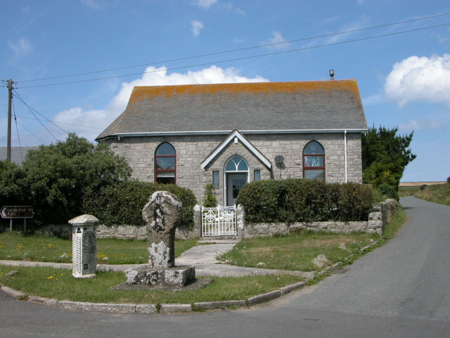
- In the Crows-an-Wra Wesleyan Chapel burial ground are a number of headstones. Mark Hattam has posted photographs of many of these gravestones.
- The Cornwall Family History Society have published Monumental Inscriptions for:
- The Parish Church - 1464 entries.
- Crows-an-Wra Wesleyan Chapel - 102 entries.
- Information on monumental inscriptions for this parish is available on-line.
- War Memorial inscriptions for St Buryan parish are separately available.
Census information for this parish (1841 - 1901) is held in the Cornwall Record Office. The Cornwall Family History Society offers a census search service for its members.
Specific census information for this parish is available as follows:
- 1841. The 1841 Census of St Buryan (HO107/141), Enumeration Districts 1 to 5, is available on-line from the Cornwall Online Census project.
- 1851.
- The 1851 Census of St Buryan (HO107/1919), Enumeration Districts 1a, 1b, 1c, 1d and 1e, is available on-line from the Cornwall Online Census project.
- The New Zealand Society of Genealogists have compiled separate surname indexes of the 1851 Census for each Cornish registration district; St Buryan is listed in Volume 30. The booklets are available in Cornwall at the Cornwall Centre, (formerly known as the Cornish Studies Library), and is also available in the Cornwall FHS Library.
- 1861. The 1861 Census of St Buryan (RG9/1599), Enumeration Districts 1C, 2B, 3A, 4B and 5A, is available on-line from the Cornwall Online Census project.
- 1871. The 1871 Census of St Buryan (RG10/2346), Enumeration Districts 1C, 2B, 3A, 4B and 5A, is available on-line from the Cornwall Online Census project.
- 1881. The 1881 Census of St Buryan (RG11/2351), Enumeration Districts 1 to 5, is available on-line from the Cornwall Online Census project.
- 1891. The 1891 Census of St Buryan (RG12/1861) is available on-line from the Cornwall Online Census project as follows:
- 1901. The 1901 Census of St Buryan (RG13/2258), Enumeration Districts 1 to 5, is available on-line from the Cornwall Online Census project.
- Anglican.
- St Buryan Was a parish church is located in OS Grid Square SW4025 and was dedicated to St Berian the Virgin in 1238.
According to tradition the Saxon King Athelstan rested for the night in the cell attached to the small Oratory of St.Buryan, (of which nothing now remains) the night before he sailed to conquer the Isles of Scilly. The next morning he made his communion and vowed that if he were successful he would found and endow a church. In 931, on the site of the Oratory was built the church of King Athelstan, and experts express the opinion that the building on the north side of the Chancel is the only remaining piece of this work. It seems quite a small building, the west wall being just east of the present screen. In 1238, the church was rebuilt much larger; this was consecrated by Bishop Briwire on August 26th. By 1473, the church building was found to be in a deplorable state, owing to the non-residence of the Dean and the Prebends. King Edward IV appointed a commission of Clergy to report on the state of the Deanery in general. The Church was found to be so ruinous that the only thing was to pull it down and re-build it.
The new Tower was erected before the old church was pulled down and that is of 14th century work; the present church was built up to the Tower in the late 15th and 16th century and it is easy to notice that the tower and nave are not in a straight line. The tower is 92 feet high and is constructed of wrought granite with a simple bold arch. In the middle of the 18th century the whole of the north wall of the church had to be pulled down and re-built again, and at the same time the small lean-to chapel on the north wall of the chancel was pulled down and the arch built up. In 1814, the church was restored yet again. In 1956 the present Lady Chapel was erected and is a gift of John Franklin Tonkin, in memory of his uncle, Robert Edmund Tonkin, of Treverven. The oak panelling was formally in the manor at Boshan near Helford, and was erected in the church by local craftsmen. - A further description and history of Buryan Church, extracted from Blight's Churches of West Cornwall - 1864, is also available.
- Another description of St Buryan church is lifted directly from The Cornish Magazine - 1898 (part 1) [Quiller-Couch 1898] from an article written by Thurston C. Peter entitled "The Collegiate Church of St. Buryan." It must be read in the context of that date. The contemporary photographs are by J. C. Burrow, F. G. S. and were printed with the original article.
- St Buryan Was a parish church is located in OS Grid Square SW4025 and was dedicated to St Berian the Virgin in 1238.
- Non-Conformist. There are Wesleyan chapels at Borah and Crows-an-Wrah. There are also Wesleyan and Bible Christian chapels in the Churchtown.
- LDS Church Records.
- The LDS Church batch numbers for St Buryan are: E006371, M006371, P006371. These are searchable by surname.
- The IGI coverage of this parish is 1653 - 1847.
- The Cornwall Record Office holdings: Baptisms 1653 - 1940, Burials 1653 - 1992, Marriages 1654 - 1970, Boyd's Marriage Index 1654 - 1812, Pallot's Marriage Index 1790 - 1812.
- The Cornish Forefathers' Society have published on CD baptisms 1701 to 1843 for this parish which can be purchased on Parish Chest.
- The Cornwall Family History Society have published on-line transcripts of:
- Pre 1813 Marriages
- 1813-37 Marriages
- 1813-37 Burials.
- Baptisms.
- Baptisms 1653 to 1812, and 1653 to 1901, are available on-line through the OPC search Facility - (C-PROP).
- St. Buryan Wesleyan Circuit baptisms 1890 to 1912 are available on-line through the OPC search Facility - (C-PROP).
- Some St Buryan Baptism registers are, additionally, available on-line.
- The Cornwall Parish Registers Index contains Baptisms 1813 to 1901 for this parish. [However, some records between 1866 and 1867 are missing]. The index is searcheable by surname.
- Marriages.
- The Cornwall Family History Society have published transcripts of: Parish Marriages 1654 to 1837, which is available in Book, CD or downloadable .pdf file formats.
- Phillimore's marriages 1654 to 1812, and parish marriages 1813 to 1901 are available on-line through the OPC search Facility - (C-PROP).
- Some St Buryan Marriage registers are available on-line.
- Burials.
- The Cornwall Family History Society have published transcripts of: Parish Burials 1813 to 1837, which is available in Book or CD.
- Burials 1653 to 1812, and 1813 to 1936, are also available on-line through the OPC search Facility - (C-PROP).
- Some St Buryan Burial registers are available on-line.
The parish of St Buryan has been in the Penzance Registration District continuously from 1st July 1837. There were originally sub-districts at Marazion, Penzance, St Buryan, St Just, St Ives and Uny-Lelant but these have now been abolished. Parishes within the district are: Gulval, Ludgvan, Madron, Marazion, Morvah, Penzance, Perranuthnoe, St. Buryan, St. Erth, St. Hilary, St. Ives, St. Just in Penwith, St. Levan, St. Michael's Mount, St. Paul, Sancreed, Sennen, Towednack, Uny-Lelant, Wolfe Rock Lighthouse, and Zennor. The Superintendant Registrar can be contacted at: Alphington House, Alverton Place, Penzance, TR18 4JJ. Tel: 01736 330093.
- An extract of TONKIN's NATURAL HISTORY OF CORNWALL (circa 1700) describes Buryan at that time.
- Hals' History of Cornwall - 1750 also gives much further historical information.
- Details from Lake's Parochial History - 1868 (part 1) concerning St Buryan is also on-line.
- The following is from [Lewis Topographical Dictionary of England - 1831] and must be read in the context of that date:
BURIAN (ST.), a parish in the hundred of PENWITH county of CORNWALL, 4¾ miles (S.W. by W.) from Penzance, containing 1495 inhabitants. The living is a rectory, and a royal peculiar, rated in the King's Books at £48. 12. 1., and in the patronage of the Crown. The church, which stands on an eminence, and serves as a land-mark to mariners, is a spacious edifice, containing some interesting monuments: it had a handsome carved carved screen and other relics of antiquity, but these were removed on its reparation in 1814: there is a small ancient cross near the south porch. St. Burian is a place of considerable antiquity, having been noted for a collegiate church founded by King Athelstan, in honour of St. Buriena, or Beriena, who had an oratory and was interred here, and on which he bestowed the privilege of sanctury and other immunities: in the 20th of Edward I. the society consisted of a dean and three prebendaries. This establishment constituted the basis of the present independent deanery, which comprises within its jurisdiction the parishes of St. Burian, St. Leven, and Sennan [sic.]: it was for a long time annexed to the bishoprick of Exeter, but was severed from it during the episcopy of Bishop Harris, who thus became the first independent dean: every vestige of the collegiate buildings has disappeared. There is a charity school under the direction of trustees, who allow the master eight guineas a year, and a residence rent free. - Some pictures of St Buryan parish are also available on-line.
- A Gazetteer of West Penwith parishes is available on-line.
The National Gazetteer of Great Britain and Ireland - 1868
"ST. BURYAN, (or St. Burian), a parish in the hundred of Penwith, in the county of Cornwall, 5 miles to the S.W. of Penzance, which is the terminus of the West Cornwall railway. It is situated in a hilly and wild district, within 4 miles of the Land's End, and contains the village of Bolleit. The village of St. Burian is of great antiquity, and was the site of a collegiate church, founded and endowed soon after the commencement of the 10th century by King Athelstan, in honour of St. Burian. It had the privilege of sanctuary, and was afterwards made a deanery. No remains of the collegiate buildings exist. Granite is the prevailing rock in the district. Numerous remains of primitive stone circles exist in the neighbourhood, among which are the Merry Maidens, two stones called the Pipers, and the Boscawen-un, being a circle of 19 stones surrounding a central one. The living is a rectory in the diocese of Exeter, of the annual value with St. Levan and Sennen, which together constitute the Deanery of St. Burian, of £1,004, in the patronage of the Prince of Wales, as Duke of Cornwall. The church is built of granite, and stands on a hill about 470 feet above the level of the sea, forming a conspicuous sea-mark. There is a national school.
"BOLLAIT, a village in the parish of St. Buryan, hundred of Penwith, in the county of Cornwall, 4 miles to the S.W. of Penzance. It is situated near the Land's End, and contains the Druidical stones called "the Pipers." One of them is 16, the other 21, feet in height. They are about 200 yards distant from each other."
"LEMORNA, a cove in the parish of St. Buryan, on the coast of Cornwall, 5 miles S.W. of Penzance. It is famed for violet axinite which is picked up here."
"MERRY MAIDENS, a Druid temple, in the parish of St. Buryan, county Cornwall, near St. Buryan. The circle is 25 feet in diameter, surrounded by 19 stones, each 4 feet high."
- Ask for a calculation of the distance from St Buryan to another place.
- OPC Assistance. The On-line Parish Clerk (OPC) scheme operates a service to help family historians; the OPC page for this parish is available on-line, from where the OPC can be contacted by email.
- West Penwith Resources have produced a genealogical website for St Buryan.
The Domesday Settlements of Cornwall, a study undertaken by the Cornwall Branch of the Historical Association, has identified and located settlements listed in the Exeter and Exchequer Domesday Survey of AD 1086. The following places have been identified in St Buryan ecclesiastical parish:
- St Buryan (Ecglosberria, Eglosberrie), Grid Reference 409257.
The parish of St Buryan contained the manors of:
- Rosemodris Manor. Survey book 1711, rentals with other manors 1759-1889, rental 1788 and presentments 1809-15, 1837-65 are in Cornwall Record Office. Survey of Rosemodris Manor in 1829 in Cornwall Record Office (collection ref: DD.BU). Survey with other manors 1710-50 in Devon Record Office, Castle Street, Exeter EX4 3PU (ref: 2065M add 28/M1).
- St Buryan Manor. Rent rolls and deeds of conveyance from 1716.
- Selena Manor. Unspecified documents in a Court of Requests case in the Public Record Office, Ruskin Avenue, Kew, Richmond TW9 4DU (ref: Req 2/VII/8; XX/139; XXIV/33). Selena manorial documents in the Cornwall Record Office, consisting of a court roll with other manors 1622-23 (ref: Acc. Jul-Sept. 1962), court rolls 1624-28, 1632-33, rentals 1727-31 and rent roll 1714-22 (ref: Acc. Jan-March 1965; Acc. Oct-Dec 1957), reeves' accounts with other manors 1627-31 (ref: X827) and rentals 1714-22, 1727-31 (ref: Acc 323, AD 32), appear to relate to the parishes of Madron and Paul rather than to the parish of St Buryan. Staff at Cornwall Record Office may be able to advise further.
- Treviddron Manor.
Court notes (3) 1716, 1729-39, surveys (3) 1750, 1754 and rentals (4) 1720-21, 1732 in Cornwall Record Office (collection ref: Vyvyan of Trelowarren). - Trevider Manor. Rentals c1800, 1851 in Cornwall Record Office (collection ref: DD.WH).
- Trevore Manor. No documents are available.
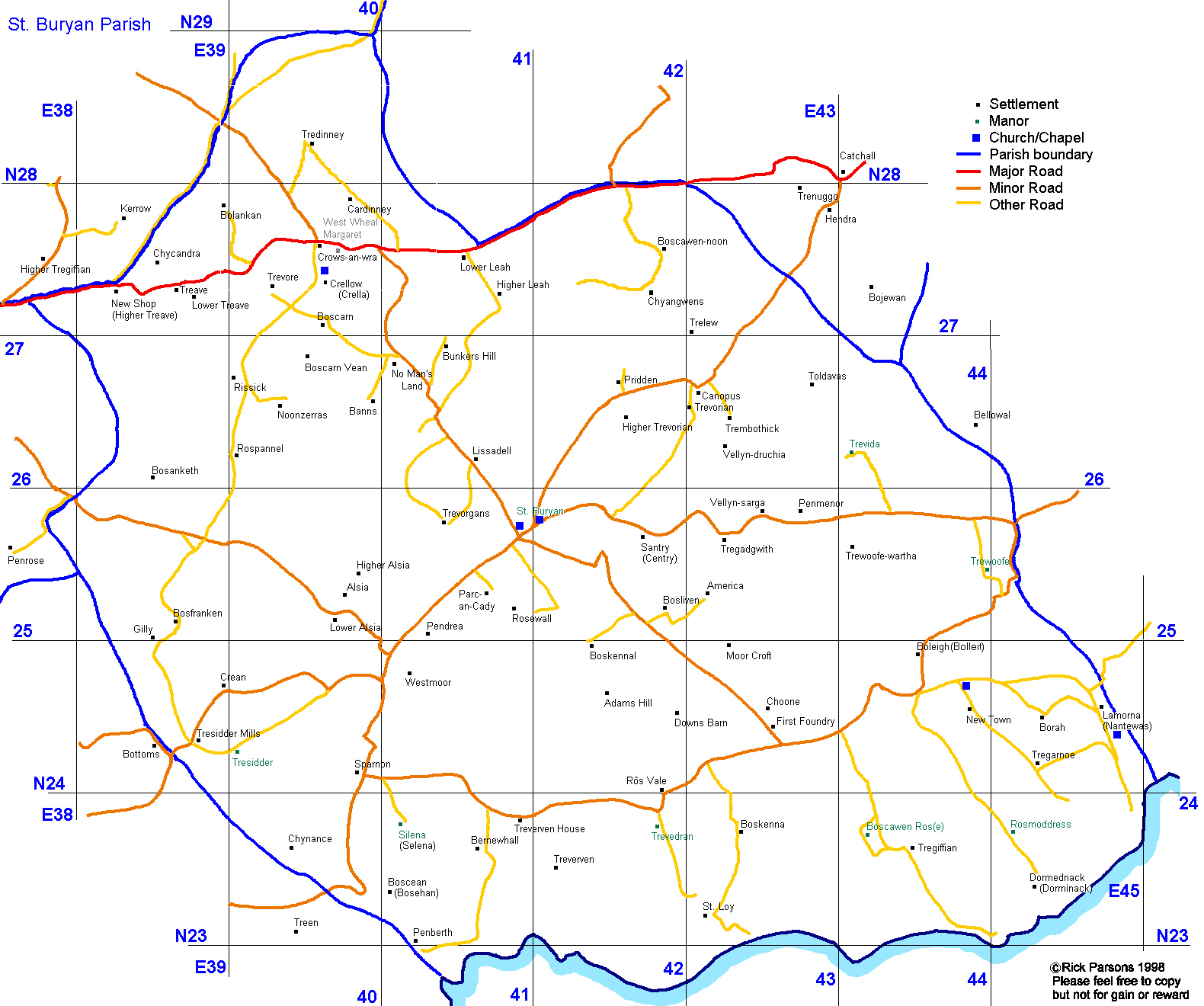
- Map of the Penzance Registration District in which the parish lies.
- A further detailed map of St Buryan parish is available on-line.
You can see maps centred on OS grid reference SW414257 (Lat/Lon: 50.074874, -5.61529), St Buryan which are provided by:
- OpenStreetMap
- Google Maps
- StreetMap (Current Ordnance Survey maps)
- Bing (was Multimap)
- Old Maps Online
- National Library of Scotland (Old Ordnance Survey maps)
- Vision of Britain (Click "Historical units & statistics" for administrative areas.)
- English Jurisdictions in 1851 (Unfortunately the LDS have removed the facility to enable us to specify a starting location, you will need to search yourself on their map.)
- Magic (Geographic information) (Click + on map if it doesn't show)
- GeoHack (Links to on-line maps and location specific services.)
- All places within the same township/parish shown on an Openstreetmap map.
- Nearby townships/parishes shown on an Openstreetmap map.
- Nearby places shown on an Openstreetmap map.
- Apprenticeship Indentures for St Buryan (1783) can be found in the Cornwall Record Office.
- St Buryan parish was part of the Penzance Union for Poor Law administration and parish relief.
- Overseers' Accounts (1728 to 1761, 1763 to 1791), Settlement Papers (1843) and Bastardy Bonds (1814 and 1843), are available in the Cornwall Record Office.
|
|
In the May of 1641 it was agreed and ordered that every Member of the House of Commons and House of Lords should make a protestation (declaration of loyalty) to the crown. The Protestation was printed and then distributed by the Members to their counties. The Protestation was to be made by everyone and the Rectors, Churchwardens and Overseers of the Poor, had to appear before the Justices of the Peace in their Hundred to make their protestation and, on returning to their parishes, any two of them were to witness the taking of the Protestation Oath by all males over the age of 18 years. All names were listed and anyone who refused was to be noted.
The Protestation Returns of 1642 for St Buryan are available on-line.
The Penwith Local History Group aims:
- To encourage and sustain public interest in the history of Penwith to provide mutual support and encouragement to members in their individual research projects, whether related to Penwith or of wider historical interest.
- To work as a group on specific research projects, with the aim of publication to an academic standard.
- To encourage the strong link with the Morrab Library, supporting the Library in its aims and activities.