
Hide
hide
Hide
DEVON MAPS AND MAP-MAKERS: MANUSCRIPT MAPS BEFORE 1840
Edited with an Introduction by Mary R. Ravenhill and Margery M. Rowe
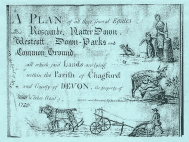
This carto-bibliography of over 1300 Devon manuscript maps will be published in two volumes in the Autumn of 2002. It contains details not only of the maps themselves, extracted from 30 separate repositories in addition to some in private hands, but also biographical information on the surveyors who made them, over a third of whom have not appeared in any national cartographic reference book. There is also an Introduction which explains the significance of these, mostly large-scale, Devon maps and how they fit into the national cartographic picture. The detailed list of maps is arranged in alphabetical order of parish for ease of reference and there is a Personal Names index. There are coloured illustrations of some of the maps and the two volumes will be presented in a slipcase.
The volumes will be an indispensable reference tool for all interested in the social history, the landscape and archaeology of Devon.
A Supplement to volumes 43 & 45 was published in March 2010, containing a carto-bibliography of 49 Devon manuscript maps which have come to light since the publication of Devon Maps and Map-Makers in 2002. The 49 maps have been extracted from ten separate repositories in addition to some in private hands. There is a short Introduction, an Appendix detailing the work and lives of the surveyors who drew the maps and a Personal Names Index. This Supplement is included in any purchase of volumes 43 & 45, and within the existing price. If purchasing the Supplement alone, there is a charge of £8 UK, £12 overseas.
Last updated - Brian Randell, 17 Oct 2014, on behalf of the Society