
Hide
Bacup
hide
Hide
hide
Hide
hide
Hide
Hide
Bacup, mun. bor., Rochdale and Whalley pars., Lancashire, 19¼ miles N. of Manchester by rail, 6400 ac., pop. 25,034; 1 Bank, 2 newspapers. Market, daily. The staple industries are cotton spinning and power-room weaving. In the neighbourhood are numerous coal-pits and vast stonequarries. Bacup was incorporated in 1882.
John Bartholomew, Gazetteer of the British Isles (1887)
Hide
Bacup Library,
St James' Square,
Bacup
OL13 9AH
Tel: 01706 873324
| South St, Bacup, Congregational |
| Brunswick Terrace Cemetery, Bacup |
Details about the census records, and indexes for Bacup.
| Christ Church, Bacup, Church of England |
| Holy Trinity, Tunstead, Church of England |
| St John the Evangelist, Bacup, Church of England |
| St Saviour Church of England, Bacup |
| Ebenezer Particular Baptist, Bacup |
| Ebenezer, Weir, Particular Baptist |
| Irwell Terrace, Baptist, Bacup |
| Providence Particular Baptist, Bacup |
| Trinity Baptist, Bacup |
| South St, Bacup, Congregational |
| Brunswick Terrace Cemetery, Bacup |
| St Mary, Bacup, Roman Catholic |
The Register Offices covering the Bacup area are Hyndburn & Rossendale, and Rochdale.
The National Gazetteer of Great Britain and Ireland - 1868
"BACUP, a chapelry in the parish of Whalley, higher division of Blackburn hundred in the county palatine of Lancaster, 6 miles to the N. of Rochdale. Manchester is its post town. It is connected with the Lancashire and Yorkshire railway by a short branch line from Ramsbottom Junction. The population are employed in the cotton and baize manufactures. The living is a perpetual curacy in the diocese of Manchester, value £250, in the patronage of Hulme's Trustees. There is also a district church called Christ Church, the living of which is a perpetual curacy, value £100, in the patronage of the Rev. J. Heyworth."
- Ask for a calculation of the distance from Bacup to another place.
In 1835 Bacup was a chapelry in the township of Newchurch in Rossendale in the parish of Whalley.
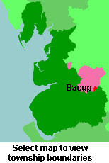
View a map of the boundaries of this town/parish.
You can see maps centred on OS grid reference SD871240 (Lat/Lon: 53.711829, -2.196595), Bacup which are provided by:
- OpenStreetMap
- Google Maps
- StreetMap (Current Ordnance Survey maps)
- Bing (was Multimap)
- Old Maps Online
- National Library of Scotland (Old Ordnance Survey maps)
- Vision of Britain (Click "Historical units & statistics" for administrative areas.)
- English Jurisdictions in 1851 (Unfortunately the LDS have removed the facility to enable us to specify a starting location, you will need to search yourself on their map.)
- Magic (Geographic information) (Click + on map if it doesn't show)
- GeoHack (Links to on-line maps and location specific services.)
- All places within the same township/parish shown on an Openstreetmap map.
- Nearby townships/parishes shown on an Openstreetmap map.
- Nearby places shown on an Openstreetmap map.
For probate purposes prior to 1858, Bacup was in the Archdeaconry of Chester, in the Diocese of Chester. The original Lancashire wills for the Archdeaconry of Chester are held at the Lancashire Record Office.
You can also see Family History Societies covering the nearby area, plotted on a map. This facility is being developed, and is awaiting societies to enter information about the places they cover.