
Hide
Bispham
hide
Hide
hide
Hide
hide
Hide
Hide
BISPHAM, a township and a parish in Fylde district, Lancashire. The township bears the name of Bispham-with-Norbreck; lies on the coast, and on the Blackpool railway, 1½ mile N of Blackpool; and has a post office of Bispham under Preston, and a r. station. Acres, 2,624; of which 985 are water. Real property, £3,307. Pop., 437. Houses, 88. The parish includes also the township of Layton-with-Warbreck: which contains the town of Blackpool and the village of Southshore. Acres, 5,865; of which 1,825 are water. Real property, £20,553. Pop., 4,344. Houses, 849. The property is much subdivided. The living is a vicarage in the diocese of Manchester. Value £235.* Patron, the Rev.Hesketh. The church is modern The chapelries of Blackpool and Southshore are separate benefices. There are an Independent chapel and a free school.
John Marius Wilson, Imperial Gazetteer of England and Wales (1870-72)
Hide
Local studies information is held at Blackpool library.
Details about the census records, and indexes for Bispham.
| Bethel Chapel, Bispham, Independent |
| Cavendish Road, Bispham, Congregational |
| Beaufort Ave, Bispham, Methodist |
| St Bernadette, Bispham, Roman Catholic |
The Register Office covering the Bispham area is Blackpool & Fylde.
The National Gazetteer of Great Britain and Ireland - 1868
"BISPHAM, a parish in the hundred of Amounderness, in the county palatine of Lancaster, 18 miles to the N.W. of Preston, its post town. It is situated on the coast of the Irish Sea, and contains the townships of Bispham-with-Norbreek and Layton-with-Warbrick, and the chapelries of Blackpool and Southshore. The Preston and Wyre branch of the Lancashire and Yorkshire railway passes near it, with which Blackpool is connected by a short line from Poulton Junction. A now line direct to Lytham has also lately been completed, and a handsome pier is in course of construction. The living is a vicarage in the diocese of Manchester, of the value of £235, in the patronage of the Rev. C. Hesketh. The church is of modern erection. There is a free school, founded in 1659 by Richard Higginson, with an income from endowment of £70 per annum."
"NORBRECK, a township in the parish of Bispham, hundred of Amounderness, county Lancaster, 3 miles N.W. of Poulton-le-Fylde. It is joined with Bispham to form a township."
- Ask for a calculation of the distance from Bispham to another place.
In 1835 the parish of Bispham contained the townships of Bispham with Norbreck and Layton with Warbreck.
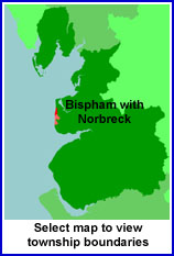
View a map of the boundaries of this town/parish.
You can see maps centred on OS grid reference SD314405 (Lat/Lon: 53.855749, -3.044446), Bispham which are provided by:
- OpenStreetMap
- Google Maps
- StreetMap (Current Ordnance Survey maps)
- Bing (was Multimap)
- Old Maps Online
- National Library of Scotland (Old Ordnance Survey maps)
- Vision of Britain (Click "Historical units & statistics" for administrative areas.)
- English Jurisdictions in 1851 (Unfortunately the LDS have removed the facility to enable us to specify a starting location, you will need to search yourself on their map.)
- Magic (Geographic information) (Click + on map if it doesn't show)
- GeoHack (Links to on-line maps and location specific services.)
- All places within the same township/parish shown on an Openstreetmap map.
- Nearby townships/parishes shown on an Openstreetmap map.
- Nearby places shown on an Openstreetmap map.
For probate purposes prior to 1858, Bispham was in the Archdeaconry of Richmond, in the Diocese of Chester. The original wills for the Archdeaconry of Richmond are held at the Lancashire Record Office.
You can also see Family History Societies covering the nearby area, plotted on a map. This facility is being developed, and is awaiting societies to enter information about the places they cover.