
Hide
Bolton le Sands
hide
Hide
hide
Hide
hide
Hide
Hide
BOLTON-LE-SANDS, a township and a parish in Lancaster district, Lancashire. The township lies on the Lancaster and Kendal canal, and on the Lancaster and Carlisle railway, contiguous to the sands of Morecambe bay, 4 miles N by E of Lancaster; and it has a station on the railway, and a post office under Lancaster. Acres, 1,571. Real property, £4,220. Pop., 692. Houses, 146. The parish contains also the townships of Over Kellet, Nether Kellet, and Slyne-with-Hest. Acres, 7,905. Real property, £13,502. Pop., 1,713. Houses, 347. The property is much subdivided. The living is a vicarage in the diocese of Manchester. Value, £187.* Patron, the Bishop of Manchester. The church is modern and very good. The vicarage of Over Kellet is a separate benefice. An endowed school has £35; other charities £101.
John Marius Wilson, Imperial Gazetteer of England and Wales (1870-72)
Hide
| Christ Church Congregational, Bolton le Sands |
| St Mary of the Angels Roman Catholic, Bolton le Sands |
Details about the census records, and indexes for Bolton le Sands.
| Christ Church Congregational, Bolton le Sands |
| St Mary of the Angels Roman Catholic, Bolton le Sands |
The Register Office covering the Bolton le Sands area is Lancaster.
The National Gazetteer of Great Britain and Ireland - 1868
"BOLTON-LE-SANDS, a parish in the hundred of Lonsdale South of the Sands, in the county palatine of Lancaster, 4 miles to the N. of Lancaster, its post town. It is situated near the coast of Morecambe Bay, and is a station on the Lancaster and Carlisle railway. The parish includes the chapelry of Over Kellet, and the townships of Nether Kellet and Slyne-with-Hest. The living is a vicarage in the diocese of Manchester, of the value of £189, in the patronage of the bishop. Here is a free grammar school, founded by Thomas Asheton in 1619, and endowed with £26 per annum. There are some other charities producing about £100 a year."
- Ask for a calculation of the distance from Bolton le Sands to another place.
In 1835 the parish of Bolton le Sands contained the townships of Bolton le Sands, Slyne with Hest, Over Kellet and Nether Kellet.
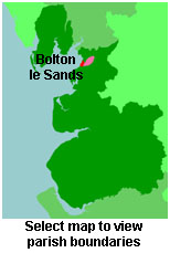
View maps of Bolton le Sands and places within its boundaries.
View a map of the boundaries of this town/parish.
You can see maps centred on OS grid reference SD482681 (Lat/Lon: 54.105923, -2.794293), Bolton le Sands which are provided by:
- OpenStreetMap
- Google Maps
- StreetMap (Current Ordnance Survey maps)
- Bing (was Multimap)
- Old Maps Online
- National Library of Scotland (Old Ordnance Survey maps)
- Vision of Britain (Click "Historical units & statistics" for administrative areas.)
- English Jurisdictions in 1851 (Unfortunately the LDS have removed the facility to enable us to specify a starting location, you will need to search yourself on their map.)
- Magic (Geographic information) (Click + on map if it doesn't show)
- GeoHack (Links to on-line maps and location specific services.)
- All places within the same township/parish shown on an Openstreetmap map.
- Nearby townships/parishes shown on an Openstreetmap map.
- Nearby places shown on an Openstreetmap map.
For probate purposes prior to 1858, Bolton le Sands was in the Archdeaconry of Richmond, in the Diocese of Chester. The original Lancashire wills for the Archdeaconry of Richmond are held at the Lancashire Record Office.
You can also see Family History Societies covering the nearby area, plotted on a map. This facility is being developed, and is awaiting societies to enter information about the places they cover.