
Hide
Bury
hide
Hide
hide
Hide
hide
Hide
Hide
BURY, a township, a town, a parish, two subdistricts, and a district in Lancashire. The township lies all within the town's assigned boundaries. Acres, 2,370. Real property, £263,333,-of which £171,785 are in railways, £1,040 in mines, and £80 in quarries. Pop., in 1841, 20,710: in 1861, 30,397. Houses, 5,971. The town lies on the river Irwell, 2 miles above its confluence with the Roach, and 8 NNW of Manchester. A branch canal goes south-westward to the Manchester and Bolton canal; and railways go westward, northward, eastward, and southward. The town has a head post office, two railway stations with telegraph, two banking offices, several chief inns, a weekly market on Saturday, and three annual fairs; is a seat of petty sessions and county courts, and a polling-place; and publishes four weekly newspapers. Woollen manufacture was formerly the main industry; and is still carried on in several large factories. Cotton manufacture, in various departments, is now the staple; received a great impulse from inventions by two natives, John and Robert Kay, and from the enterprise of the late Sir Robert Peel's father; and maintains at present upwards of twelve factories for spinning and weaving, two for printing and bleaching, and two for dyeing. There are also three large iron foundries, several smaller ones, machine-making works, hat-making houses, and other manufacturing establishments.
John Marius Wilson, Imperial Gazetteer of England and Wales (1870-72) more ...
Hide
| St John Baptist, Bircle, Church of England |
| St John, Bury, Church of England |
| St Mary the Virgin, Bury, Church of England |
| St Paul Church of England, Bury |
| St Thomas, Pimhole, Church of England |
| Bethel, Bury, Independent |
| Castle Croft, Bury, Congregational |
| Four Lane Ends Congregational, Bury |
| New Rd Independent, Bury |
| Silver St/Bank St Unitarian, Bury |
Details about the census records, and indexes for Bury.
"From Dr. V. D. Lipman's inspection of the originals of the census returns of 1851, it is clear that the 'synagogues' at Bury, Lutterworth and Haslingden (and one of those at Leeds) were in fact places of worship of a non-Jewish (though perhaps Judaising) sect who called themselves 'Israelites.' "from Cecil Roth's history of provincial Jewry published in 1940
The Register Office covering the Bury area is Bury.
- Ask for a calculation of the distance from Bury to another place.
In 1835 the parish of Bury contained the townships of Bury, Tottington Higher End, Tottington Lower End, Walmersley and Shuttleworth, Cowpe, Lench, Newhall Hey and Hall Carr, Elton and Heap.
View maps of Bury and places within its boundaries.
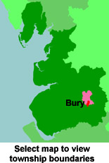
View a map of the boundaries of this town/parish.
You can see maps centred on OS grid reference SD816106 (Lat/Lon: 53.591383, -2.279427), Bury which are provided by:
- OpenStreetMap
- Google Maps
- StreetMap (Current Ordnance Survey maps)
- Bing (was Multimap)
- Old Maps Online
- National Library of Scotland (Old Ordnance Survey maps)
- Vision of Britain (Click "Historical units & statistics" for administrative areas.)
- English Jurisdictions in 1851 (Unfortunately the LDS have removed the facility to enable us to specify a starting location, you will need to search yourself on their map.)
- Magic (Geographic information) (Click + on map if it doesn't show)
- GeoHack (Links to on-line maps and location specific services.)
- All places within the same township/parish shown on an Openstreetmap map.
- Nearby townships/parishes shown on an Openstreetmap map.
- Nearby places shown on an Openstreetmap map.
The Workhouse site has an interesting description of Bury workhouse.
For probate purposes prior to 1858, Bury was in the Archdeaconry of Chester, in the Diocese of Chester. The original Lancashire wills for the Archdeaconry of Chester are held at the Lancashire Record Office.
You can also see Family History Societies covering the nearby area, plotted on a map. This facility is being developed, and is awaiting societies to enter information about the places they cover.