
Hide
Chatburn
hide
Hide
hide
Hide
hide
Hide
Hide
CHATBURN, a township and a chapelry in Whalley parish, Lancashire. The township lies on the verge of the county, on the river Ribble, at the terminus of the Blackburn and Clitheroe railway, 2½ miles NE of Clitheroe. Acres, 720. Pop., 521. Houses, 111. The chapelry includes also the township of Worston; and its post town is Clitheroe, under Blackburn. Acres, 1,580. Rated property, £2,425. Pop., 605. Houses, 132. The property is divided among a few. Cotton manufacture and lime-burning are carried on. The living is a vicarage in the diocese of Manchester. Value, £165. Patrons, Hulme's Trustees. The church was struck by lightning in 1854; and the steeple of it had to be taken down and rebuilt.
John Marius Wilson, Imperial Gazetteer of England and Wales (1870-72)
Hide
Local studies information is held at Clitheroe library.
Details about the census records, and indexes for Chatburn.
| Pendle Ave Wesleyan Methodist, Chatburn |
The Register Office covering the Chatburn area is Ribble Valley.
The National Gazetteer of Great Britain and Ireland - 1868
"CHATBURN, a township and chapelry in the parish of Whalley, in the higher division of the hundred of Blackburn, in the county of Lancaster, 2 miles E. of Clitheroe. It is a station on the western division of the Lancashire and Yorkshire railway. The township, which is united with that of Worston, is watered by the river Ribble. The living is a perpetual curacy in the diocese of Manchester, value £165, in the patronage of Hulme's Trustees. The church, dedicated to Christ, is a stone edifice in the Romanesque style of architecture. Here are National schools for both sexes. There are extensive lime-works in the vicinity. The Duke of Buccleuch is lord of the manor:"
- Ask for a calculation of the distance from Chatburn to another place.
In 1835 Chatburn was a township in the Parish of Whalley.
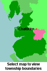
View maps of Chatburn and places within its boundaries.
View a map of the boundaries of this town/parish.
You can see maps centred on OS grid reference SD770443 (Lat/Lon: 53.89469, -2.352211), Chatburn which are provided by:
- OpenStreetMap
- Google Maps
- StreetMap (Current Ordnance Survey maps)
- Bing (was Multimap)
- Old Maps Online
- National Library of Scotland (Old Ordnance Survey maps)
- Vision of Britain (Click "Historical units & statistics" for administrative areas.)
- English Jurisdictions in 1851 (Unfortunately the LDS have removed the facility to enable us to specify a starting location, you will need to search yourself on their map.)
- Magic (Geographic information) (Click + on map if it doesn't show)
- GeoHack (Links to on-line maps and location specific services.)
- All places within the same township/parish shown on an Openstreetmap map.
- Nearby townships/parishes shown on an Openstreetmap map.
- Nearby places shown on an Openstreetmap map.
For probate purposes prior to 1858, Chatburn was in the Archdeaconry of Chester, in the Diocese of Chester. The original Lancashire wills for the Archdeaconry of Chester are held at the Lancashire Record Office.
You can also see Family History Societies covering the nearby area, plotted on a map. This facility is being developed, and is awaiting societies to enter information about the places they cover.