
Hide
Childwall
hide
Hide
hide
Hide
hide
Hide
Hide
CHILDWALL, a township in West Derby district and a parish in West Derby and Prescot districts, Lancashire. The township lies adjacent to the Liverpool and Manchester railway, between Broad Green and Roby stations, 4¼ miles E of Liverpool. Acres, 828. Real property, £3,198. Pop., 174. Houses, 25. The parish includes also the townships of Wavertree, Allerton, Garston, Speke, Hale, Halewood, Little Woolton, and Much Woolton; extends from the suburbs of Liverpool, 9 miles up the Mersey; and contains the post offices of Wavertree, Garston, Broad-Green, Woolton, Grassendale, and Halewood under Liverpool, and Hale under Warrington. Acres, 1,327; of which 6,850 are water. Real property, £11, 561. Pop., 1,917. Houses, 3,115. The property is much subdivided. The manor, with Childwall Hall, belongs to the Marquis of Salisbury. A cell to Holme priory anciently stood near Childwall Hall. The living is a vicarage in the dio. of Chester. Value, £456.* Patron, the Bishop of Chester. The church was repaired in 1853. The rectories of St. Mary, Wavertree, Woolton, and Halewood, the vicarages of Garston, Aigburth, and Grassendale, and the p. curacy of Hale are separate benefices. Dissenting chapels and public schools are in various parts. Markland, the critic, and the Child of Hale, were natives.
John Marius Wilson, Imperial Gazetteer of England and Wales (1870-72)
Hide
Local studies information is held at Liverpool library.
Details about the census records, and indexes for Childwall.
The Register Office covering the Childwall area is Liverpool.
The National Gazetteer of Great Britain and Ireland - 1868
"CHILDWALL, a parish in the hundred of West Derby, in the county of Lancaster, 5 miles from Liverpool, and 4 from Prescot. It includes the townships of Allerton, Childwall, Halewood, Speke, Little Woolton, and Much Woolton, and the chapelries of Garston, Hale, and Wavertree. The living is a vicarage in the diocese of Chester, value £456, in the patronage of the bishop. There are also eight district churches in this parish, the livings of which are perpetual curacies, viz.: that at Wavertree, value £117; at Woolton, value £220, which, with that at Halewood, is in the patronage of the vicar; at Garston, value £138, in the patronage of Richard Watt, Esq.; at Hale, value £105, in the patronage of J. I. Blackburn, Esq.; St. Mary's, value £100, in the patronage of the Bishop of Chester; St. Anne, Aigburth, and another at Grassendale, in the patronage of trustees. At a short distance from the village is Childwall Hall, a seat of the Marquis of Salisbury."
"THINGWALL, a hamlet in the parish of Childwall, hundred of West Derby, county Lancaster, 6 miles W. of Liverpool, on the Manchester railway."
- Ask for a calculation of the distance from Childwall to another place.
In 1835 the parish of Childwall contained the townships of Childwall, Hale, Halewood, Speke, Garston, Allerton, Much Woolton, Little Woolton and Wavertree.
View maps of Childwall and places within its boundaries.
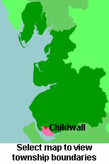
View a map of the boundaries of this town/parish.
You can see maps centred on OS grid reference SJ416892 (Lat/Lon: 53.396105, -2.880307), Childwall which are provided by:
- OpenStreetMap
- Google Maps
- StreetMap (Current Ordnance Survey maps)
- Bing (was Multimap)
- Old Maps Online
- National Library of Scotland (Old Ordnance Survey maps)
- Vision of Britain (Click "Historical units & statistics" for administrative areas.)
- English Jurisdictions in 1851 (Unfortunately the LDS have removed the facility to enable us to specify a starting location, you will need to search yourself on their map.)
- Magic (Geographic information) (Click + on map if it doesn't show)
- GeoHack (Links to on-line maps and location specific services.)
- All places within the same township/parish shown on an Openstreetmap map.
- Nearby townships/parishes shown on an Openstreetmap map.
- Nearby places shown on an Openstreetmap map.
For probate purposes prior to 1858, Childwall was in the Archdeaconry of Chester, in the Diocese of Chester. The original Lancashire wills for the Archdeaconry of Chester are held at the Lancashire Record Office.
You can also see Family History Societies covering the nearby area, plotted on a map. This facility is being developed, and is awaiting societies to enter information about the places they cover.