
Hide
Coppull
hide
Hide
hide
Hide
hide
Hide
Hide
COPPULL, a township and a chapelry in Standish parish, Lancashire. The township lies on the Wigan and Preston railway, 6 miles N by W of Wigan; and has a station on the railway, and a post office under Chorley. Acres, 2,279. Real property, £6,152; of which £1,950 are in mines. Pop., 1,230. Houses, 218. The chapelry was constituted in 1842; and was at first more extensive than the township, with a pop. of upwards of 2,000; but is now conterminate with the township. The property is much subdivided. The living is a vicarage in the dio. of Manchester. Value, £120. Patron, the Rector of Standish. The church was rebuilt in 1861. There is a Wesleyan chapel, a national school, and charities £44.
John Marius Wilson, Imperial Gazetteer of England and Wales (1870-72)
Hide
Local studies information is held at Chorley library.
The following books contain useful information about the history of Coppull and the surrounding area.
- 'Coppull Memories' (now out of print) by Keith Lees & Geoff Bellis. This is A Countryside Publication ISBN 0 86157 203 3. It is a photographic collection. The co-author Geoff Bellis holds the full collection (in ring binders) from which these were chosen. He lends them to local people, inviting them to add names that are missing.
| St Oswald, Coppull, Roman Catholic |
Details about the census records, and indexes for Coppull.
The Register Office covering the Coppull area is Chorley.
The National Gazetteer of Great Britain and Ireland - 1868
"COPPULL, a chapelry in the parish of Standish, hundred of Leyland, in the county of Lancaster, 4 miles S.W. of Chorley, and 5 from Wigan: It is a station on the Manchester and Preston section of the London and North Western railway. Near the village are extensive collieries and bleach-fields. The living is a perpetual curacy in the diocese of Manchester, value £120, in the patronage of the Rector of Standish. The church is a plain structure. The charities amount to £34 per annum. Here are a Wesleyan Methodist chapel, a National school for both sexes, and a Sunday school. The Right Hon. E. Cardwell is lord of the manor."
- Ask for a calculation of the distance from Coppull to another place.
In 1835 Coppull was a township in the parish of Standish.
Various documents about the history of Coppull.
View maps of Coppull and places within its boundaries.
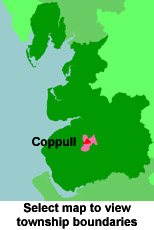
View a map of the boundaries of this town/parish.
You can see maps centred on OS grid reference SD564137 (Lat/Lon: 53.618217, -2.660799), Coppull which are provided by:
- OpenStreetMap
- Google Maps
- StreetMap (Current Ordnance Survey maps)
- Bing (was Multimap)
- Old Maps Online
- National Library of Scotland (Old Ordnance Survey maps)
- Vision of Britain (Click "Historical units & statistics" for administrative areas.)
- English Jurisdictions in 1851 (Unfortunately the LDS have removed the facility to enable us to specify a starting location, you will need to search yourself on their map.)
- Magic (Geographic information) (Click + on map if it doesn't show)
- GeoHack (Links to on-line maps and location specific services.)
- All places within the same township/parish shown on an Openstreetmap map.
- Nearby townships/parishes shown on an Openstreetmap map.
- Nearby places shown on an Openstreetmap map.
For probate purposes prior to 1858, Coppull was in the Archdeaconry of Chester, in the Diocese of Chester. The original Lancashire wills for the Archdeaconry of Chester are held at the Lancashire Record Office.
You can also see Family History Societies covering the nearby area, plotted on a map. This facility is being developed, and is awaiting societies to enter information about the places they cover.