
Hide
Culcheth
hide
Hide
hide
Hide
hide
Hide
Hide
CULCHETH, a township and a sub-district in Leigh district, Lancashire. The township is in Newchurch-Kenyon parish; lies on the Liverpool and Manchester railway, 3 miles S of Leigh; and has a church, Methodist chapels, an endowed school for boys and girls, and charities £49. Acres, 5,361. Real property, £10,339. Pop., 2,214. Houses, 444. Culcheth Hall is the seat of the Withingtons. The sub-district includes also two townships of Leigh parish. Acres, 10,427. Pop., 10,881. Houses, 2,204.
John Marius Wilson, Imperial Gazetteer of England and Wales (1870-72)
Hide
| Cross Lane, Risley, Presbyterian |
Details about the census records, and indexes for Culcheth.
| Church Lane, Newchurch in Culcheth, Church of England |
| Church of the Transfiguration, Birchwood, Church of England |
| Ellesmere Rd, Methodist, Culcheth |
| Fearnhead Lane Independent Methodist, Risley |
| Hob Hey Lane Independent Methodist, Twiss Green |
| Risley, Primitive Methodist |
| Cross Lane, Risley, Presbyterian |
| Thomas Risley Church, Locking Stumps, Presbyterian |
The Register Office covering the Culcheth area is Wigan and Leigh.
Information from Culcheth Village Online.
The National Gazetteer of Great Britain and Ireland - 1868
"CULCHETH, (or Newchurch) a township in the parish of Winwick, in the county of Lancaster, 3 miles S. of Leigh. The village, which is large, contains the Union poorhouse. The charities produce about £50 a year.
"NEWCHURCH, (or Newchurch Kenyon), a chapelry and township in the parish of Winwick, hundred of West Derby, county Lancaster, 3 miles S. of Leigh, 6 E. by S. of Newton-in-Makerfield, and 5 N. of Warrington. It is situated near the Sankey canal and the line of the North-Western railway. The inhabitants are partly engaged in the cotton-mills and in the manufacture of hardware. The impropriate tithes have been commuted for a rent-charge of £169. The living is a rectory with the curacy of Bury Lane annexed, in the diocese of Chester, value £180. The church is a modern edifice containing 365 free sittings.
"RISLEY, a moss in the hundred of West Derby, county Lancaster, 4 miles N.E. of Warrington, and 18 E. of Liverpool. It is situated in the valley of the river Mersey, near the Sankey and Bridgwater canals."
"BURY LANE, a hamlet in the township of Culcheth, or Newchurch, and parish of Winwick, hundred of West Derby, in the county palatine of Lancaster, 3 miles to the S. of Leigh. It gives name to a station on the Liverpool and Manchester railway. The living is a perpetual curacy annexed to the rectory of Newchurch Kenyon, in the diocese of Chester."
John Marius Wilson, Imperial Gazetteer of England and Wales - 1870-2
- Ask for a calculation of the distance from Culcheth to another place.
In 1835 Culcheth was a township in the parish of Winwick.
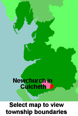
View a map of the boundaries of this town/parish.
You can see maps centred on OS grid reference SJ665940 (Lat/Lon: 53.441519, -2.506004), Culcheth which are provided by:
- OpenStreetMap
- Google Maps
- StreetMap (Current Ordnance Survey maps)
- Bing (was Multimap)
- Old Maps Online
- National Library of Scotland (Old Ordnance Survey maps)
- Vision of Britain (Click "Historical units & statistics" for administrative areas.)
- English Jurisdictions in 1851 (Unfortunately the LDS have removed the facility to enable us to specify a starting location, you will need to search yourself on their map.)
- Magic (Geographic information) (Click + on map if it doesn't show)
- GeoHack (Links to on-line maps and location specific services.)
- All places within the same township/parish shown on an Openstreetmap map.
- Nearby townships/parishes shown on an Openstreetmap map.
- Nearby places shown on an Openstreetmap map.
For probate purposes prior to 1858, Culcheth was in the Archdeaconry of Chester, in the Diocese of Chester. The original Lancashire wills for the Archdeaconry of Chester are held at the Lancashire Record Office.
You can also see Family History Societies covering the nearby area, plotted on a map. This facility is being developed, and is awaiting societies to enter information about the places they cover.