
Hide
Eccleston
hide
Hide
hide
Hide
hide
Hide
Hide
ECCLESTON, a village and a township in Chorley district; and a parish in Chorley and Wigan districts, Lancashire. The village stands on the river Yarrow, 2 miles E of Croston r. station, and 4½ W of Chorley; was once a market-town; had also fairs on 14 April and 4 Nov.; and has a post office under Chorley. The town ship comprises 2,085 acres. Real property, £4,891. Pop. in 1851, 671; in 1861, 965. Houses, 184. The parish contains also the townships of Heskin, Parbold, and Wrightington. Acres, 8,361. Real property, £18,076; of which £830 are in mines, and £461 in quarries. Pop., 3,496. Houses, 655. The property is not much divided. The increase of pop. in Eccleston township between 1851 and 1861 arose from the erection of cotton factories. The living is a rectory in the diocese of Manchester. Valne, £965.* Patron, Will. Yates, Esq. The church is ancient. The vicarage of Douglas and the p. curacy of Wrightington are separate benefices. There are three dissenting chapels, a R. Catholic chapel, a free grammar school, and charities £50.
John Marius Wilson, Imperial Gazetteer of England and Wales (1870-72)
Hide
Local studies information is held at Chorley library.
Details about the census records, and indexes for Eccleston.
| St. Agnes, Eccleston, Roman Catholic |
The Register Office covering the Eccleston area is Chorley.
The National Gazetteer of Great Britain and Ireland - 1868
"ECCLESTON, a parish in the hundred of Leyland, county palatine of Lancaster, 5 miles W. of Chorley, its post town, 2 S.E. of the Creston station on the East Lancashire line, and 3 S.W. of Euxton station on the London and North-Western railway. It is situated on the river Yarrow, and the Leeds canal passes through the parish. The townships of Heskin, Parbold, and Wrightington, and the hamlets of Highmoor, Fairhurst, Mossey Lee, and Dangerous Corner are included in it. The collieries and quarries, which are extensively worked, give employment to many of the people. There is also a cotton factory, and some hands are employed in the hand-loom weaving. The living is a rectory in the diocese of Manchester, value £965. The parish church is an ancient stone structure, with a handsome stained-glass window. It is dedicated to St. Mary, and contains an effigy in brass, a Gothic altar tomb, and many interesting monuments. There are also the following district churches:-Douglas, perpetual curacy, value £134, in the patronage of the rector; Wrightington, perpetual curacy in the patronage of the rector. The parochial charities produce about £50 per annum. The Wesleyans have a place of worship. There is a free grammar school, and a National school for both sexes. Charles Scarisbrick, Esq., is lord of the manor."
"DOUGLAS, a chapelry in the parish of Eccleston, hundred of Leyland, in the county of Lancaster, 5½ miles N.E. of Ormskirk. The living is a perpetual curacy, value £76, in the patronage of the Rector of Eccleston."
- Ask for a calculation of the distance from Eccleston to another place.
In 1835 the parish of Eccleston contained the townships of Eccleston, Heskin, Wrightington and Parbold.
View maps of Eccleston and places within its boundaries.
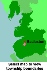
View a map of the boundaries of this town/parish.
You can see maps centred on OS grid reference SD521174 (Lat/Lon: 53.650537, -2.72595), Eccleston which are provided by:
- OpenStreetMap
- Google Maps
- StreetMap (Current Ordnance Survey maps)
- Bing (was Multimap)
- Old Maps Online
- National Library of Scotland (Old Ordnance Survey maps)
- Vision of Britain (Click "Historical units & statistics" for administrative areas.)
- English Jurisdictions in 1851 (Unfortunately the LDS have removed the facility to enable us to specify a starting location, you will need to search yourself on their map.)
- Magic (Geographic information) (Click + on map if it doesn't show)
- GeoHack (Links to on-line maps and location specific services.)
- All places within the same township/parish shown on an Openstreetmap map.
- Nearby townships/parishes shown on an Openstreetmap map.
- Nearby places shown on an Openstreetmap map.
For probate purposes prior to 1858, Eccleston was in the Archdeaconry of Chester, in the Diocese of Chester. The original Lancashire wills for the Archdeaconry of Chester are held at the Lancashire Record Office.
- Lancashire Family History & Heraldry Society - Chorley Branch
- Lancashire Family History & Heraldry Society - Preston Branch
- Lancashire Parish Register Society
You can also see Family History Societies covering the nearby area, plotted on a map. This facility is being developed, and is awaiting societies to enter information about the places they cover.