
Hide
Edgworth
hide
Hide
hide
Hide
hide
Hide
Hide
EDGEWORTH, a township and a sub-district in Bolton parish, Lancashire. The township lies near the Bolton and Blackburn railway, 7½ miles NNW of Bolton. Acres, 2,480. Real property, £4,378; of which £465 are in quarries. Pop., 1,350. Houses, 273. There are a cotton-mill, a school-church, Independent chapels of 1822 and 1867, and a Wesleyan chapel of 1863. The sub-district includes two other townships. Acres, 4,430. Pop., 2,025. Houses, 406.
John Marius Wilson, Imperial Gazetteer of England and Wales (1870-72)
Hide
Local studies information is held at Bolton library.
| Horrocks Rd Independent, Edgworth |
| Bolton Rd Wesleyan Methodist, Edgworth |
Details about the census records, and indexes for Edgworth.
| Horrocks Rd Independent, Edgworth |
| Bolton Rd Wesleyan Methodist, Edgworth |
| St Aldhelm, Edgworth, Roman Catholic |
The Register Office covering the Edgworth area is Blackburn.
The National Gazetteer of Great Britain and Ireland - 1868
"EDGEWORTH, a township in the parish of Bolton le Moors, hundred of Salford, county palatine of Lancaster, 7 miles N.W. of Bolton. The Entwistle station on the Yorkshire and Lancashire railway is near the village. It is situated on the old Roman road, and was, till recently, only a common. The people are mostly employed in cotton spinning and in the quarries. There is a place licensed for Divine service. The Independents and Wesleyans have each a chapel, and there is a Church school."
- Ask for a calculation of the distance from Edgworth to another place.
In 1835 Edgworth was a township in the parish of Bolton.
The village now lies within the boundaries of North Turton Parish Council along with the villages of Belmont, Chapeltown, Entwistle and Quarlton. North Turton is part of Blackburn with Darwen Borough.
Information about boundaries and administrative areas is available from A Vision of Britain through time.
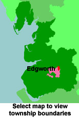
View a map of the boundaries of this town/parish.
You can see maps centred on OS grid reference SD744190 (Lat/Lon: 53.666729, -2.389344), Edgworth which are provided by:
- OpenStreetMap
- Google Maps
- StreetMap (Current Ordnance Survey maps)
- Bing (was Multimap)
- Old Maps Online
- National Library of Scotland (Old Ordnance Survey maps)
- Vision of Britain (Click "Historical units & statistics" for administrative areas.)
- English Jurisdictions in 1851 (Unfortunately the LDS have removed the facility to enable us to specify a starting location, you will need to search yourself on their map.)
- Magic (Geographic information) (Click + on map if it doesn't show)
- GeoHack (Links to on-line maps and location specific services.)
- All places within the same township/parish shown on an Openstreetmap map.
- Nearby townships/parishes shown on an Openstreetmap map.
- Nearby places shown on an Openstreetmap map.
For probate purposes prior to 1858, Edgworth was in the Archdeaconry of Chester, in the Diocese of Chester. The original Lancashire wills for the Archdeaconry of Chester are held at the Lancashire Record Office.
You can also see Family History Societies covering the nearby area, plotted on a map. This facility is being developed, and is awaiting societies to enter information about the places they cover.