
Hide
Everton
hide
Hide
hide
Hide
hide
Hide
Hide
EVERTON, a suburban township, seven chapelries, and a sub-district, in Walton-on-the-Hill parish, West Derby district, Lancashire. The township is suburban to Liverpool; lies within Liverpool borough, on the NE side of the town, contiguous to Kirkdale; and has a post office under Liverpool, 1½ mile distant from the Liverpool head-office. It had a village older than Liverpool, situated on an eminence, commanding an extensive view over the Mersey to Wales and the Irish channel; but it takes its present character from the growth and prosperity of Liverpool; has long been a favourite residence of many merchants; and comprises numerous airy streets and numerous elegant villas. It contains the cottage occupied by Prince Rupert in 1644; a mansion, called St. Domingo, built with money accruing from a French prize ship; the workhouse of West Derby district; the Liverpol hospital for infections diseases, about to be rebuilt in 1869; the Liverpool collegiate institution; several national or other public schools; a public cemetery, formed in 1825; St. George's church, built in 1814, at a cost of £12,000; four churches built between 1829 and 1857; St. Saviour's church, in the Lombardic style, at a cost of £5,400, built in 1866; Emmanuel church, of very costly character, built in 1867; two Scotch Presbyterian chapels, built in 1863 and 1866; several English dissenting chapels; and a Roman Catholic church, designated St. Edward's college church, built in 1859 to the extent of three eastern chapels, measuring internally 280 feet in length, possessing fine features of the mediaeval style of architecture, and designed as part of an intended cathedral. Acres of the township, 700. Real property, £162,758; of which £742 are in quarries. Pop. in 1851, 25,883; in 1861, 54,848. Houses, 9,288. The chapelries are St. George, St. Augustine, St. Chrysostom, St. Peter, Christchurch, St. Saviour, and Emmanuel. The living of St. Chrysostom is a vicarage, and the other livings are p. curacies, in the diocese of Chester. Value of St. George and St. Augustine, each £300; of St. Chrysostom, £400; of the others, not reported. Patron of Christchurch, T. B. Horsfall, Esq.; of Emmanuel, I - D. Anderson, Esq.; of St. Peter, not reported; of the others, Trustees. The sub-district includes also the township of Kirkdale. Acres, 1,832. Pop., 70,983. Houses, 11,830.
John Marius Wilson, Imperial Gazetteer of England and Wales (1870-72)
Hide
Details about the census records, and indexes for Everton.
| Long Lane, Cemetery, Everton |
| Long Lane, Everton, Jewish Cemetery |
| Necropolis, Everton, Cemetery |
| Everton Valley, Liverpool, Presbyterian |
The Register Office covering the Everton area is Liverpool
The National Gazetteer of Great Britain and Ireland - 1868
"EVERTON, a township in the parish of Walton-on-the-Hill, in the borough of Liverpool and county palatine Lancaster, 1 mile N. of Liverpool, of which it is a populous suburb. It is situated on high ground, commanding fine views over the sea, the town of Liverpool, the river Mersey, and part of Cheshire. There are quarries of red sandstone, and extensive water-works. The union workhouse for West Derby is in this township. There are five district churches, viz. St. George's, St. Augustine's, Christchurch, St. Peter's, and St. Chrysostom's; that dedicated to St. George was erected in 1814, at the cost of £12,000; it stands on the spot formerly occupied by the beacon erected in the 13th century by Ranulph de Blundeville. All the livings are perpetual curacies in the diocese of Chester, the two first-named of the value of £200. Here is a Roman Catholic cathedral not yet completed."
- Ask for a calculation of the distance from Everton to another place.
In 1835 Everton was a township in the parish of Walton on the Hill.
Information about boundaries and administrative areas is available from A Vision of Britain through time.
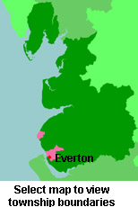
View a map of the boundaries of this town/parish.
You can see maps centred on OS grid reference SJ360922 (Lat/Lon: 53.422512, -2.964464), Everton which are provided by:
- OpenStreetMap
- Google Maps
- StreetMap (Current Ordnance Survey maps)
- Bing (was Multimap)
- Old Maps Online
- National Library of Scotland (Old Ordnance Survey maps)
- Vision of Britain (Click "Historical units & statistics" for administrative areas.)
- English Jurisdictions in 1851 (Unfortunately the LDS have removed the facility to enable us to specify a starting location, you will need to search yourself on their map.)
- Magic (Geographic information) (Click + on map if it doesn't show)
- GeoHack (Links to on-line maps and location specific services.)
- All places within the same township/parish shown on an Openstreetmap map.
- Nearby townships/parishes shown on an Openstreetmap map.
- Nearby places shown on an Openstreetmap map.
For probate purposes prior to 1858, Everton was in the Archdeaconry of Chester, in the Diocese of Chester. The original Lancashire wills for the Archdeaconry of Chester are held at the Lancashire Record Office.
You can also see Family History Societies covering the nearby area, plotted on a map. This facility is being developed, and is awaiting societies to enter information about the places they cover.