
Hide
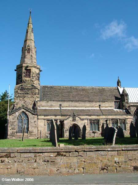
St Cuthbert, Halsall, Church of England
hide
Hide
Hide
St Cuthbert,
Halsall Rd,
Halsall
Lancashire
Hide
The church has a graveyard. Lancashire Record Office hold copies of the Monumental Inscriptions on gravestones with details of deaths 1911-1992.
1911-1992
It was founded in Norman times. The first Rector of Halsall was Robert (no second name known), c.1190. There was originally a Norman Church founded on the site (no documents are known with the date of foundation). The early English church was started around 1290. The church has undergone numerous alterations over the centuries.
Scheme of alterations:
- Norman church of simple form, with chancel and porch, but without aisles.
- About 1290, the addition of a north aisle and chapels, and a tower and spire.
- According to the book (Halsall 1320-1965), the tower and spire appear to have been dismantled round 1340-1350,
- Work seems to have stopped around 1350, probably due to the plague sweeping the country, which is said to have killed half the population of England.
- The tower and spire were later rebuilt in a different location of the church, using some of the original materials.
The church has six bells and a clock which chimes quarter hourly 24 hours a day.
This site provides historical information about churches, other places of worship and cemeteries. It has no connection with the churches themselves. For current information you should contact them directly.
Baptisms
1606-1640
1606-1754
Transcript of baptisms 1606-1754 by the Lancashire Parish Register Society - Volume 105
1653-1887
1653-1887
1664-1893
1892-1914
1892-1914
Marriages
1606-1640
1606-1754
Transcript of marriages 1606-1754 by the Lancashire Parish Register Society - Volume 105
1653-1904
1653-1956
1664-1884
1812-1837
Burials
1606-1640
1606-1754
Transcript of burials 1606-1754 by the Lancashire Parish Register Society - Volume 105
1653-1919
1653-1949
1664-1893
- OpenStreetMap
- Google Maps
- StreetMap (Current Ordnance Survey maps)
- Bing (was Multimap)
- Old Maps Online
- National Library of Scotland (Old Ordnance Survey maps)
- Vision of Britain (Click "Historical units & statistics" for administrative areas.)
- English Jurisdictions in 1851 (Unfortunately the LDS have removed the facility to enable us to specify a starting location, you will need to search yourself on their map.)
- Magic (Geographic information) (Click + on map if it doesn't show)
- GeoHack (Links to on-line maps and location specific services.)