
Hide
Harwood
hide
Hide
hide
Hide
hide
Hide
Hide
HARWOOD, a village, a township, and a chapelry in Bolton-le-Moors parish, Lancashire. The village stands 3 miles NE of Bolton r. station, and 4 W of Bury. The township comprises 1,100 acres. Post town, Bolton. Real property, £5,556; of which £800 are in mines, and £400 in quarries. Pop., 2,055. Houses, 435. The property is much subdivided. There are a cotton mill and a and was constituted in 1845. Pop., 1,525. Houses, 326. The living is a p. curacy in the diocese of Manchester. Value, £90.* Patrons, Trustees. The church is a recent structure, in the early English style; and has a small tower. There are chapels for Wesleyans and Primitive Methodists, and a national school.
John Marius Wilson, Imperial Gazetteer of England and Wales (1870-72)
Hide
Local studies information is held at Bolton library.
Details about the census records, and indexes for Harwood.
| Longsight, Harwood, Wesleyan Methodist |
| St Brendan, Harwood, Roman Catholic |
The Register Office covering the Harwood area is Bolton.
The National Gazetteer of Great Britain and Ireland - 1868
"HARWOOD, a chapelry and township in the parish of Bolton-le-Moors, hundred of Salford, county Lancaster, 3 miles N.E. of Bolton railway station, and 4 from Bury The village, which is considerable, contains calico and dimity mills, and a colliery. The living is a perpetual curacy in the diocese of Manchester, value £100. Christ Church is a modern structure of stone, with a small tower. The Primitive Methodists have a chapel, and there is a National school."
- Ask for a calculation of the distance from Harwood to another place.
In 1835 Harwood was a township in the parish of Bolton.
Information about boundaries and administrative areas is available from A Vision of Britain through time.
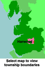
View maps of Harwood and places within its boundaries.
View a map of the boundaries of this town/parish.
You can see maps centred on OS grid reference SD746121 (Lat/Lon: 53.604664, -2.385615), Harwood which are provided by:
- OpenStreetMap
- Google Maps
- StreetMap (Current Ordnance Survey maps)
- Bing (was Multimap)
- Old Maps Online
- National Library of Scotland (Old Ordnance Survey maps)
- Vision of Britain (Click "Historical units & statistics" for administrative areas.)
- English Jurisdictions in 1851 (Unfortunately the LDS have removed the facility to enable us to specify a starting location, you will need to search yourself on their map.)
- Magic (Geographic information) (Click + on map if it doesn't show)
- GeoHack (Links to on-line maps and location specific services.)
- All places within the same township/parish shown on an Openstreetmap map.
- Nearby townships/parishes shown on an Openstreetmap map.
- Nearby places shown on an Openstreetmap map.
For probate purposes prior to 1858, Harwood was in the Archdeaconry of Chester, in the Diocese of Chester. The original Lancashire wills for the Archdeaconry of Chester are held at the Lancashire Record Office.
You can also see Family History Societies covering the nearby area, plotted on a map. This facility is being developed, and is awaiting societies to enter information about the places they cover.