
Hide
Holcombe
hide
Hide
hide
Hide
hide
Hide
Hide
HOLCOMBE, a village, a chapelry, and a sub-district in Bury district, Lancashire. The village stands near the river Irwell and the Bury and Haslingden railway, 1¼ mile SW of Ramsbottom r. station, and 4½ N by W of Bury. The chapelry is in Tottington-Lower-End township, Bury parish; and was recently made ecclesiastically parochial. Post town, Ramsbottom, under Manchester. Pop., 2,511. A tower or column, to the memory of Sir Robert Peel, stands on Holcombe hill. The living is a rectory in the diocese of Manchester. Value, £175.* Patron, the Rector of Bury. The church is in the early decorated English style; and consists of nave, N transept, and chancel, with tower and fine spire. The sub-district consists mainly of part of Tottington-Lower-End township, but includes a pendicle of Walmersley-cum-Shuttleworth township. Pop., 6,645. Houses, 1,276.
John Marius Wilson, Imperial Gazetteer of England and Wales (1870-72)
Hide
Local studies information is held at Bury library.
The Register Office covering the Holcombe area is Bury.
- Ask for a calculation of the distance from Holcombe to another place.
In 1835 Holcombe was a chapelry in the township of Tottington Lower End in the parish of Bury.
View maps of Holcombe and places within its boundaries.
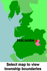
View a map of the boundaries of this town/parish.
You can see maps centred on OS grid reference SD780166 (Lat/Lon: 53.64544, -2.334268), Holcombe which are provided by:
- OpenStreetMap
- Google Maps
- StreetMap (Current Ordnance Survey maps)
- Bing (was Multimap)
- Old Maps Online
- National Library of Scotland (Old Ordnance Survey maps)
- Vision of Britain (Click "Historical units & statistics" for administrative areas.)
- English Jurisdictions in 1851 (Unfortunately the LDS have removed the facility to enable us to specify a starting location, you will need to search yourself on their map.)
- Magic (Geographic information) (Click + on map if it doesn't show)
- GeoHack (Links to on-line maps and location specific services.)
- All places within the same township/parish shown on an Openstreetmap map.
- Nearby townships/parishes shown on an Openstreetmap map.
- Nearby places shown on an Openstreetmap map.
For probate purposes prior to 1858, Holcombe was in the Archdeaconry of Chester, in the Diocese of Chester. The original Lancashire wills for the Archdeaconry of Chester are held at the Lancashire Record Office.
You can also see Family History Societies covering the nearby area, plotted on a map. This facility is being developed, and is awaiting societies to enter information about the places they cover.