
Hide
Kirkby Ireleth
hide
Hide
hide
Hide
hide
Hide
Hide
KIRKBY-IRELETH, a township and a parish in Ulverston district, Lancashire. The township lies on the Duddon estuary, and on the Furness railway, 4½ miles NW of Ulverston; has a station, of the name of Kirkby, on the railway; is divided, for local purposes, into the sections of Middle Quarter, Low Quarter, Heathwaite, and Woodlands; and contains the hamlets of Beckside, Chapel, Cross-Beck, Gill-Beck, Beanthwaite, Sandside, Soutergate, and Grisebeck, the last of which has a Post office under Ulverston. Acres, 9,010. Real property, £11,844; of which £5,600 are in quarries. Pop. in 1851, 1,748; in 1861, 1,666. Houses, 332. The manor, with most of the land, belongs to the Duke of Devonshire. Kirkby-Hall was long the seat of the Kirkby family; contains some curious ancient decorations; and is now a farm house. Quarries of excellent dark blue roofing slate are on Kirkby-Moor, in Middle-Quarter; extend in a series along a hill; give constant employment to about 350 men; and send their produce to all parts of the kingdom. A large proportion of the township is moor and mountain. Many families are engaged in cockle fishing in the Duddon. The parish contains also the township of West Broughton, and that of Dunnerdale-with-Seathwaite. Acres, 25,740. Real property, £20,729. Pop. in 1951, 3,366; in 1861, 3,138. Houses, 628. The property, except in K..I. township, is much subdivided. The manor of West Broughton belonged, for several centuries till 1487, to the Broughton family; and that of Seathwaite belongs to J. J. Rawlinson, Esq. The living is a vicarage in the diocese of Carlisle. Value, £140. Patrons, the Dean and Chapter of York. The church stands at Beckside; is ancient, but good; consists of nave, N aisle, and chancel, with a tower; and contains ancient monuments of the Kirkby family. The p. curacies of Woodlands, Broughton-in-Furness, and Seathwaite are separate benefices. There are two parochial schools, and charities £88.
John Marius Wilson, Imperial Gazetteer of England and Wales (1870-72)
Hide
Local studies information is held at Cumbria Record Office & Local Studies Library, Barrow.
Details about the census records, and indexes for Kirkby Ireleth.
The Register Office covering the Kirkby Ireleth area is Ulverston.
Kirkby Ireleth parish from Mannix & Co., History, Topography and Directory of Westmorland, 1851.
Residents in 1882 found in Mannex's directory of Furness and Cartmel.
The National Gazetteer of Great Britain and Ireland - 1868
"KIRKBY-IRELETH, a parish in the hundred of Lonsdale North of the Sands, county Lancaster, 5 miles W. of Ulverston, its post town, and 27 N.W. of Lancaster. It is situated on the river Duddon, and is a station on the Furness line of railway. It contains the townships of Broughton and Dunderdale-with-Leathwaite, and is divided into four districts, called Heathwaite, Woodlands, Low Quarter, and Middle Quarter. The parish is chiefly moorland, but some parts are enclosed and well cultivated. There are extensive slate quarries in the Middle Quarter, employing between 300 and 400 hands. Copper and iron abound. Many of the inhabitants are employed in the cockle fishing, for which the Duddon is famous. An extensive tract of land has been reclaimed from the sea, near the mouth of the Duddon. The living is a vicarage in the diocese of Carlisle, value £125, in the patronage of the Dean and Chapter of York. The church, situated at Beckside, is an ancient stone structure with a tower containing five bells. It is dedicated to St. Cuthbert, and has a stained-glass window and some ancient monuments. There is also a district church at Broughton-in-Furness, the living of which is a perpetual curacy, value 108. At Middle Quarter is a Baptist chapel and a parochial school, and there is a church school at Beckside. Kirkby Hall, formerly the seat of the Kirkby family, is now a farmhouse. The Earl of Burlington is lord of the manor."
"HERDHOUSE, an extra parochial place in the parish of Kirkby Ireleth, county Lancaster, 2 miles from Broughton."
"MARSHFIELD, an extra parochial place adjoining the parish of Kirkby Ireleth, county Lancaster, near Broughton."
"QUARTER HIGH, a township in the parish of Kirkby-Ireleth, hundred of Lonsdale North of the Sands, county Lancaster."
"MIDDLE-QUARTER, a township in the parish of Kirkby-Ireleth, hundred of Lonsdale North of the Sands, county Lancaster, 5 miles N.W. of Ulverston. It is a considerable village, situated near the river Dudden."
"LOW QUARTER, a township in the parish of Kirkby-Ireleth, hundred of Lonsdale North of the Sands, county palatine of Lancaster, 5 miles W. of Ulverston."
"HEATHWAITE, a chapelry in the parish of Kirkby Ireleth, hundred of Lonsdale North of the Sands, county Lancaster, 3 miles E. of Broughton, and 6 S.W. of Hawkshead. It is situated near the river Duddon, which separates it from the county of Westmoreland, and is united with Woodland."
- Ask for a calculation of the distance from Kirkby Ireleth to another place.
In 1835 the parish of Kirkby Ireleth contained the townships of Kirkby Ireleth, Broughton West, Dunnerdale & Seathwaite and Angerton.
Information about boundaries and administrative areas is available from A Vision of Britain through time.
The history of Kirkby Ireleth as described in Mannex's directory of Furness and Cartmel, 1882.
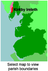
View maps of Kirkby Ireleth and places within its boundaries.
View a map of the boundaries of this town/parish.
You can see maps centred on OS grid reference SD237857 (Lat/Lon: 54.261539, -3.172329), Kirkby Ireleth which are provided by:
- OpenStreetMap
- Google Maps
- StreetMap (Current Ordnance Survey maps)
- Bing (was Multimap)
- Old Maps Online
- National Library of Scotland (Old Ordnance Survey maps)
- Vision of Britain (Click "Historical units & statistics" for administrative areas.)
- English Jurisdictions in 1851 (Unfortunately the LDS have removed the facility to enable us to specify a starting location, you will need to search yourself on their map.)
- Magic (Geographic information) (Click + on map if it doesn't show)
- GeoHack (Links to on-line maps and location specific services.)
- All places within the same township/parish shown on an Openstreetmap map.
- Nearby townships/parishes shown on an Openstreetmap map.
- Nearby places shown on an Openstreetmap map.
For probate purposes prior to 1858, Kirkby Ireleth was in the peculiar of the Dean of the Chapter of York whose records are deposited at the Borthwick Institute. A list of the probate records at York which relate specifically to the ancient parish of Kirkby Ireleth (including Broughton-in-Furness and Seathwaite) is available at Cumbria Record Office, Barrow.
You can also see Family History Societies covering the nearby area, plotted on a map. This facility is being developed, and is awaiting societies to enter information about the places they cover.