
Hide
Osmotherley
hide
Hide
hide
Hide
hide
Hide
Hide
OSMOTHERLEY, a township in Ulverstone parish, Lancashire; 2 miles N W by N of Ulverstone. Acres, 1,140. Real property, £2,318. Pop. in 1851, 325; in 1861, 419. Houses, 81. The increase of pop. arose from the extension of mining operations. The manor belongs to the Duke of Buccleuch. A church-school is here, and is used as a chapel of ease.
John Marius Wilson, Imperial Gazetteer of England and Wales (1870-72)
Hide
Local studies information is held at Cumbria Record Office & Local Studies Library, Barrow.
Details about the census records, and indexes for Osmotherley.
The Register Office covering the Osmotherley area is Ulverston.
The National Gazetteer of Great Britain and Ireland - 1868
"OSMOTHERLEY, a township in the parish of Ulverston, hundred of Lonsdale North of the Sands, county Lancaster, 3 miles from the parish church, and 2½ N.W. of Ulverston. The township consists of a few straggling farmhouses. There is a Church school, endowed with £16 per annum, in which Divine service is performed every alternate Sunday. The Duke of Buccleuch is lord of the manor."
- Ask for a calculation of the distance from Osmotherley to another place.
In 1835 Osmotherley was a township in the parish of Ulverston.
View maps of Osmotherley and places within its boundaries.
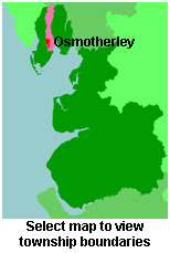
View a map of the boundaries of this town/parish.
You can see maps centred on OS grid reference SD273804 (Lat/Lon: 54.213919, -3.116335), Osmotherley which are provided by:
- OpenStreetMap
- Google Maps
- StreetMap (Current Ordnance Survey maps)
- Bing (was Multimap)
- Old Maps Online
- National Library of Scotland (Old Ordnance Survey maps)
- Vision of Britain (Click "Historical units & statistics" for administrative areas.)
- English Jurisdictions in 1851 (Unfortunately the LDS have removed the facility to enable us to specify a starting location, you will need to search yourself on their map.)
- Magic (Geographic information) (Click + on map if it doesn't show)
- GeoHack (Links to on-line maps and location specific services.)
- All places within the same township/parish shown on an Openstreetmap map.
- Nearby townships/parishes shown on an Openstreetmap map.
- Nearby places shown on an Openstreetmap map.
For probate purposes prior to 1858, Osmotherley was in the Archdeaconry of Richmond, in the Diocese of Chester. The original Lancashire wills for the Archdeaconry of Richmond are held at the Lancashire Record Office.
You can also see Family History Societies covering the nearby area, plotted on a map. This facility is being developed, and is awaiting societies to enter information about the places they cover.