
Hide
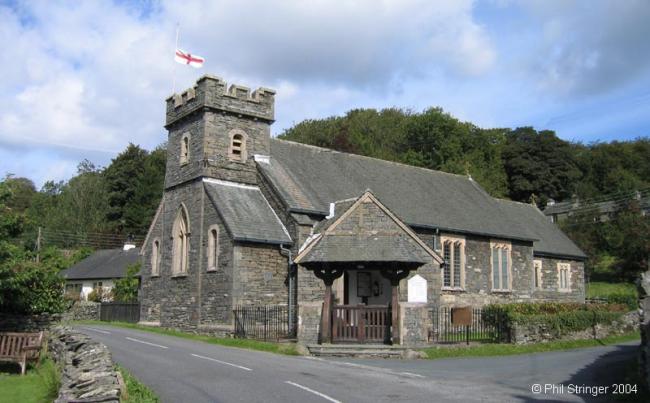
All Saints, Satterthwaite, Church of England
hide
Hide
Hide
Hide
The church has a graveyard. Monumental inscriptions of burials between 1850-1889 are held at Lancashire Record Office.
1850-1889
Transcript of monumental inscriptions 1850-1889 held by Lancashire Archives - Searchroom
The church at Satterthwaite is of unknown origin, but it was in existence as early as 1577. It was rebuilt and enlarged in 1835, in the early English style of architecture, with a square tower in which is one bell. The living is now a vicarage in the gift of the vicar of Hawkshead, and in the incumbency of the Rev. T. Edge Wright. Its value is £473. A small school was erected in 1849 by public subscription, aided by grant from the Committee of Council on Education. The school has an average attendance of 76, and is under the charge of Mr. J. B. Dobson.The parochial district of Satterthwaite is comprised within and is co-extensive with the limits of the three hamlets of Satterthwaite, Grizedale, and Dale Park.from Mannex's directory of Furness & Cartmel, 1882
Whilst every effort has been made to record exact details of record office and library holdings you are recommended to check with them before visiting to ensure that they do hold the records and years you wish to examine. Similarly check with transcript publishers to ensure they cover the records and years you require before making a purchase.
Satterthwaite entries were originally made in the Hawkshead registers. Satterthwaite was not licensed for marriages until 1866. The burial ground, which is some distance from the church, was consecrated only in 1867.
The Cumbria Record Office, Barrow hold:
- Baptisms 1766-1893
- Baptisms - 1766-1812
This site provides historical information about churches, other places of worship and cemeteries. It has no connection with the churches themselves. For current information you should contact them directly.
Baptisms
1750-1914
Copy of Bishop's Transcript of baptisms 1750-1914 held by Lancashire Archives - DRC 2/34A-38
1766-1840
Transcript of baptisms 1766-1840 by the Lancashire Parish Register Society - Volume 135
Burials
1750-1914
Copy of Bishop's Transcript of burials 1750-1914 held by Lancashire Archives - DRC 2/34A-38
It is located at SD3386892371 (Lat/Lon 54.322614, -3.018254). You can see this on maps provided by:
- OpenStreetMap
- Google Maps
- StreetMap (Current Ordnance Survey maps)
- Bing (was Multimap)
- Old Maps Online
- National Library of Scotland (Old Ordnance Survey maps)
- Vision of Britain (Click "Historical units & statistics" for administrative areas.)
- English Jurisdictions in 1851 (Unfortunately the LDS have removed the facility to enable us to specify a starting location, you will need to search yourself on their map.)
- Magic (Geographic information) (Click + on map if it doesn't show)
- GeoHack (Links to on-line maps and location specific services.)