
Hide
Skerton
hide
Hide
hide
Hide
hide
Hide
Hide
SKERTON, a suburban village and a township-chapelry in Lancaster parish, Lancashire. The village is suburban to Lancaster; communicates with that town by a five-arched bridge, across the river Lune; and has a post-office under Lancaster, and a police station. The chapelry comprises 1,186 acres. Real property, £6,179; of which £90 are in fisheries. Pop., 1,556. Houses, 317. The property is subdivided. The living is a p. curacy in the diocese of Manchester. Value, £100. Patrons, Trustees. The church is a neat building, with a pinnacled tower. There is an endowed school with £12 a year.
John Marius Wilson, Imperial Gazetteer of England and Wales (1870-72)
Hide
| St Luke Church of England, Skerton |
| Halton Road Cemetery, Skerton |
Details about the census records, and indexes for Skerton.
The Register Office covering the Skerton area is Lancaster.
The National Gazetteer of Great Britain and Ireland - 1868
"SKERTON, a township in the parish of Lancaster, hundred of Lonsdale South of the Sands, county Lancaster, three-quarters of a mile N. of Lancaster. It is a large village separated from the town of Lancaster by the river Lune. There is a considerable salmon fishery. The living is a perpetual curacy in the diocese of Manchester, value £100, in the patronage of trustees. The church was erected in 1833. There is a National school endowed by Henry Williamson in 1767 with £10 a year."
- Ask for a calculation of the distance from Skerton to another place.
In 1835 Skerton was a township in the parish of Lancaster.
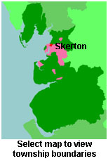
View maps of Skerton and places within its boundaries.
View a map of the boundaries of this town/parish.
You can see maps centred on OS grid reference SD468636 (Lat/Lon: 54.06601, -2.81441), Skerton which are provided by:
- OpenStreetMap
- Google Maps
- StreetMap (Current Ordnance Survey maps)
- Bing (was Multimap)
- Old Maps Online
- National Library of Scotland (Old Ordnance Survey maps)
- Vision of Britain (Click "Historical units & statistics" for administrative areas.)
- English Jurisdictions in 1851 (Unfortunately the LDS have removed the facility to enable us to specify a starting location, you will need to search yourself on their map.)
- Magic (Geographic information) (Click + on map if it doesn't show)
- GeoHack (Links to on-line maps and location specific services.)
- All places within the same township/parish shown on an Openstreetmap map.
- Nearby townships/parishes shown on an Openstreetmap map.
- Nearby places shown on an Openstreetmap map.
For probate purposes prior to 1858, Skerton was in the Archdeaconry of Richmond, in the Diocese of Chester. The original Lancashire wills for the Archdeaconry of Richmond are held at the Lancashire Record Office.
You can also see Family History Societies covering the nearby area, plotted on a map. This facility is being developed, and is awaiting societies to enter information about the places they cover.