
Hide
St Helen, St Helen's, Church of England
hide
Hide

Hide
St Helen,
Church St,
St Helens
Lancashire
Hide
The church has/had a graveyard.
1970 - Graves at the parish church uncovered and removed to St Helens Borough Cemetery. What exists now now is a large plot at St Helens cemetery which contains the remains of everyone from the Parish church. It's plot 17/18, apart from the odd Armed Forces stone all that's there to indicate the burials is a stone plinth reading, "Within this plot lie the remains of persons formerly laid to rest in the burial ground of the Parish church of St.Helen and reinterred in December 1970."
The monumental inscriptions for this church cemetery are contained in the libary at the Society of Genealogists in London.
1755-1917
The origin of the church from 1552 made reference to 'St Elyn's chapel' very small 'consisting only of a 'challis and a lytle bell.' This was a 'chapel of ease' for travellers from Prescot to Warrington.
1816 - The church, located on Church Street at St Helens was enlarged and became known as St Marys. The burial ground was opened.
1858 - The current St Helens Cemetery opened. It was sometimes referred to as the Windleshaw Cemetery or now as the St Helens Borough Cemetery.
1861 - The burial ground at St Marys (formerly St Helens) was closed by an order-in-council.
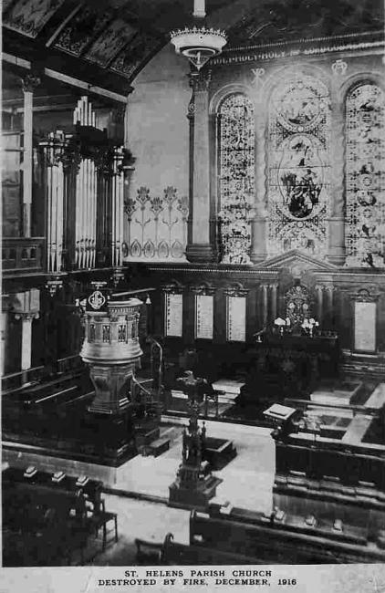
1916 - St Helens Parish Church burned down. The congregation worshipped at the Town Hall for ten years.
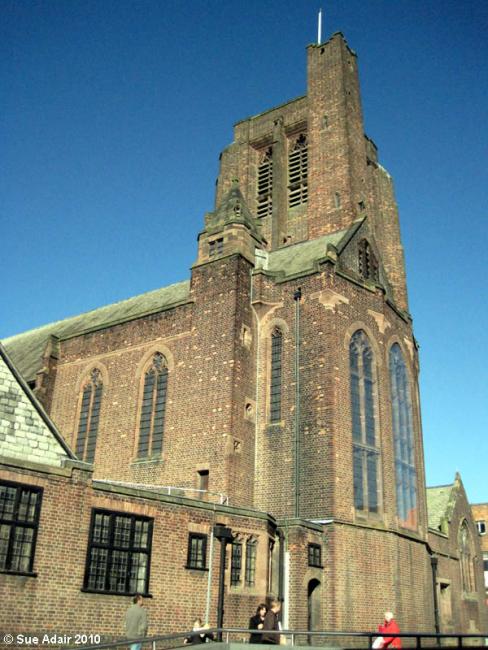
1926 - The present parish church was consecrated and the name reverted back to St. Helen.
This site provides historical information about churches, other places of worship and cemeteries. It has no connection with the churches themselves. For current information you should contact them directly.
Baptisms
1676-1697
1713-1787
Transcript of baptisms 1713-1787 by the Lancashire Parish Register Society - Volume 107
1713-1903
1713-1903
1788-1812
Transcript of baptisms 1788-1812 by the Lancashire Parish Register Society - Volume 111
1813-1841
Transcript of baptisms 1813-1841 by the Lancashire Parish Register Society - Volume 184
1813-1855
Marriages
1723-1787
Transcript of marriages 1723-1787 by the Lancashire Parish Register Society - Volume 107
1723-1902
1723-1902
1723-1930
1788-1837
Transcript of marriages 1788-1837 by the Lancashire Parish Register Society - Volume 111
1813-1841
Transcript of marriages 1813-1841 by the Lancashire Parish Register Society - Volume 184
1813-1855
Burials
1721-1763
1721-1787
Transcript of burials 1721-1787 by the Lancashire Parish Register Society - Volume 107
1721-1925
1778-1925
1788-1812
Transcript of burials 1788-1812 by the Lancashire Parish Register Society - Volume 111
1813-1841
Transcript of burials 1813-1841 by the Lancashire Parish Register Society - Volume 184
1813-1855
- OpenStreetMap
- Google Maps
- StreetMap (Current Ordnance Survey maps)
- Bing (was Multimap)
- Old Maps Online
- National Library of Scotland (Old Ordnance Survey maps)
- Vision of Britain (Click "Historical units & statistics" for administrative areas.)
- English Jurisdictions in 1851 (Unfortunately the LDS have removed the facility to enable us to specify a starting location, you will need to search yourself on their map.)
- Magic (Geographic information) (Click + on map if it doesn't show)
- GeoHack (Links to on-line maps and location specific services.)