
Hide
Stalybridge
hide
Hide
hide
Hide
hide
Hide
Hide
"Stalybridge (or Staleybridge), parl. and mun. bor., and manufacturing town, Stockport and Mottram in Longden Dale pars., Cheshire, and Ashton under Lyne par., Lancashire, on river Tame, 7½ miles E. of Manchester by rail - mun. bor., pop. 25,977; parl. bor., 2214 ac., pop. 42,863; 2 Banks, 2 newspapers. Market-day, Saturday. Stalybridge is said to derive its name from the Staveleighs, who formerly resided here; but the town is entirely modern, dating from the year 1776. It has communication in all directions by railway. The principal mfrs. are the spinning of cotton yarns and the weaving of calicoes, but there are also numerous iron foundries and machine shops. Stalybridge was made a mun. bor. in 1857, and a parl. bor. in 1867; its municipal limits were extended in 1881, and its parliamentary limits in 1885. It returns 1 member to Parl."
John Bartholomew, Gazetteer of the British Isles, 1887
Hide
Local studies information previously housed at Stalybridge is now held in the new Local Studies and Archives Centre at Tameside Central Library in Ashton. They have made available a summary of the records, and finding aids that they hold.
Details about the census records, and indexes for Stalybridge.
The Register Office covering the Stalybridge area is Tameside.
The National Gazetteer of Great Britain and Ireland - 1868
"STALYBRIDGE, a chapelry, township, market and post town in the parish of Ashton-under-Lyne, hundred of Salford, county Lancaster, 2 miles W. of Ashton, and 8 N.E. of Stockport. It is connected by branch lines with the London and North-Western, the Manchester, Sheffield, and Lincolnshire, and Lancashire and Yorkshire railways. It is a prosperous manufacturing town, situated upon the Tame, under a hill called "Wild Bank," which rises 1,300 feet above sea-level. This place derives its name from the Staveleighs, a family who resided here, and from the bridge over the river, which has recently been rebuilt at an expense of £4,000, and connects the county of Lancaster with that of Chester. The growth of the town has been rapid since 1776, when the first cotton-mill was erected here. The streets are paved and lighted with gas, and there is an abundant supply of good water. The staple trade is in cotton-spinning, but it, and the cloth trade, once predominant, have declined. Large quantities of firebricks are manufactured. The population of the borough is probably nearly 27,000. It contains a townhall, lock-up, savings-bank, news-room, and two commercial branch banks. The Huddersfield canal passes in the vicinity. There are five churches in the borough, St. Paul's, St. John's, Dukinfield, St. George's, Holy Trinity, and the old chapel of the place, St. George Cockerhill. Market day is Saturday. A fair is held on 5th March."
- Ask for a calculation of the distance from Stalybridge to another place.
A parish (SJ 9798) created in 1894 out of Stayley and part of Dukinfield (in Cheshire) and part of Ashton under Lyne (in Lancashire). Transferred to the county of Greater Manchester in 1974. Please also see the Stalybridge, Cheshire pages.
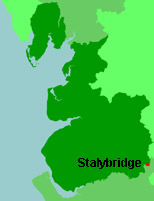
View a map of the boundaries of this town/parish.
You can see maps centred on OS grid reference SJ963993 (Lat/Lon: 53.490761, -2.056713), Stalybridge which are provided by:
- OpenStreetMap
- Google Maps
- StreetMap (Current Ordnance Survey maps)
- Bing (was Multimap)
- Old Maps Online
- National Library of Scotland (Old Ordnance Survey maps)
- Vision of Britain (Click "Historical units & statistics" for administrative areas.)
- English Jurisdictions in 1851 (Unfortunately the LDS have removed the facility to enable us to specify a starting location, you will need to search yourself on their map.)
- Magic (Geographic information) (Click + on map if it doesn't show)
- GeoHack (Links to on-line maps and location specific services.)
- All places within the same township/parish shown on an Openstreetmap map.
- Nearby townships/parishes shown on an Openstreetmap map.
- Nearby places shown on an Openstreetmap map.
For probate purposes prior to 1858, Stalybridge was in the Archdeaconry of Chester, in the Diocese of Chester. The original Lancashire wills for the Archdeaconry of Chester are held at the Lancashire Record Office.
You can also see Family History Societies covering the nearby area, plotted on a map. This facility is being developed, and is awaiting societies to enter information about the places they cover.