
Hide
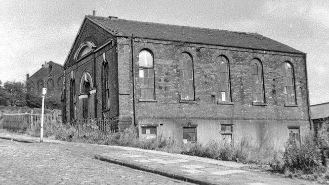
Blandford St formerly Portland St Wesleyan Methodist, Stalybridge
hide
Hide
Hide
Blandford St formerly Portland St,
Stalybridge
Lancashire
Hide
The Wesleyans were in existence in Stalybridge as a religious sect prior to the year 1800. From the time when the Rev. John Wesley preached at Staley Hall, December 7th 1745, and again on Sunday, May 11th 1747, when he spoke, as is supposed, from Rassbottom Cross, the village received regular visitations from Wesleyan preachers. In 1762 there existed a Society of Wesleyans, at Higham Fold, the site of which was obliterated in the construction of Mellor Road.In 1805 a Wesleyan Meeting Room existed near the Angel Inn, Rassbottom from whence the worshippers went to "Holden's Garrett", Cocker Hill. The first Wesleyan Chapel, in Caroline Street, was opened in 1815, and enlarged in 1827 at a cost of £400. A branch place of worship was formed on Cocker Hill, and a suitable chapel built in 1864 in Blandofrd Street, then known as Portland Street. This building was sold to the Presbyterians in 1869, who used it for some number of years. It is now known as Hartley Works, and is the property of Messrs. Dawson and Co. Engineers. The present Wesleyan Chapel, Carolinme Street, was built in 1872 and cost about £4,000. It contains an organ whaich cost £700.
The Sunday School was first held in the old chapel, and appears to have been formed about 1820. In the year 1825 the Canal Street School was built; great improvements and additions have been made in recent years.
'Bygone Stalybridge' by Samuel Hill, published in 1907
The Wesleyan Methodist church was formed in the 18th century from religous societies founded by John Wesley and his preachers. It suffered many secessions, but was the largest Nonconformist denomination in the 19th century. In 1932 the Wesleyan Methodists joined with the Primitive Methodists and the United Methodists to form the Methodist Church of Great Britain.
This site provides historical information about churches, other places of worship and cemeteries. It has no connection with the churches etc. themselves.
- OpenStreetMap
- Google Maps
- StreetMap (Current Ordnance Survey maps)
- Bing (was Multimap)
- Old Maps Online
- National Library of Scotland (Old Ordnance Survey maps)
- Vision of Britain (Click "Historical units & statistics" for administrative areas.)
- English Jurisdictions in 1851 (Unfortunately the LDS have removed the facility to enable us to specify a starting location, you will need to search yourself on their map.)
- Magic (Geographic information) (Click + on map if it doesn't show)
- GeoHack (Links to on-line maps and location specific services.)