
Hide
Torver
hide
Hide
hide
Hide
hide
Hide
Hide
TORVER, a township-chapelry in Ulverston parish, Lancashire; on the Coniston railway, 2 miles SW of Coniston. It has a post-office under Windermere, and a r. station. Acres, 3,670. Real property, £1,180. Pop., 194. Houses, 42. The manor belongs to the Queen. The scenery is highly picturesque. The living is a rectory in the diocese of Carlisle. Value, £113. Patron, the Rev. A. Peache. The church was rebuilt in 1848. There are an endowed school with £8 a year, and charities £7.
John Marius Wilson, Imperial Gazetteer of England and Wales (1870-72)
Hide
Local studies information is held at Cumbria Record Office & Local Studies Library, Barrow and at Kendal library.
The following books contain useful information about the history of Torver and the surrounding area.
- John Dawson, 'Torver', published by Phillimore & Co., 1985.
| St Luke, Torver, Church of England |
| Sunnybank Baptist, Torver |
Details about the census records, and indexes for Torver.
| St Luke, Torver, Church of England |
| Sunnybank Baptist, Torver |
The Register Office covering the Torver area is Ulverston.
Residents in 1882 found in Mannex's directory of Furness and Cartmel.
The National Gazetteer of Great Britain and Ireland - 1868
"TORVER, a township in the parish of Ulverston, hundred of Lonsdale North of the Sands, county Lancaster, 11 miles N. of Ulverston, and 6 S.W. of Hawkeshead. It is a station on the Coniston branch of the Ulverston and Lancaster and Furness Junction railway. The village is situated near Coniston Water. The land is rocky and barren. The living is a perpetual curacy in the diocese of Carlisle, value £59. The parochial charities produce about £15, of which £8 go to the school founded by John Fleming in 1777. The manor is royal."
- Ask for a calculation of the distance from Torver to another place.
In 1835 Torver was a chapelry and a township in the parish of Ulverston.
The history of Torver as described in Mannex's directory of Furness and Cartmel, 1882.
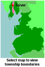
View maps of Torver and places within its boundaries.
View a map of the boundaries of this town/parish.
You can see maps centred on OS grid reference SD280948 (Lat/Lon: 54.343888, -3.109136), Torver which are provided by:
- OpenStreetMap
- Google Maps
- StreetMap (Current Ordnance Survey maps)
- Bing (was Multimap)
- Old Maps Online
- National Library of Scotland (Old Ordnance Survey maps)
- Vision of Britain (Click "Historical units & statistics" for administrative areas.)
- English Jurisdictions in 1851 (Unfortunately the LDS have removed the facility to enable us to specify a starting location, you will need to search yourself on their map.)
- Magic (Geographic information) (Click + on map if it doesn't show)
- GeoHack (Links to on-line maps and location specific services.)
- All places within the same township/parish shown on an Openstreetmap map.
- Nearby townships/parishes shown on an Openstreetmap map.
- Nearby places shown on an Openstreetmap map.
For probate purposes prior to 1858, Torver was in the Archdeaconry of Richmond, in the Diocese of Chester. The original Lancashire wills for the Archdeaconry of Richmond are held at the Lancashire Record Office.
You can also see Family History Societies covering the nearby area, plotted on a map. This facility is being developed, and is awaiting societies to enter information about the places they cover.