
Hide
Ulverston
hide
Hide
hide
Hide
hide
Hide
Hide
ULVERSTON - popularly Ooston - a town, a township, a parish, a sub-district, and a district, in Lancashire. The town stands on the Furness railway, near the influx of the river Leven to Morecambe bay, 5 miles NE of Dalton-in-Furness; belonged to the Saxon magnate Ulph or Ulpha; was given, by King Stephen, to Furness abbey; superseded Dalton, after the dissolution of monasteries, as practically the capital of Furness; is now a seat of petty sessions and county courts, and a polling place; publishes two weekly newspapers; carries on brewing, iron-founding, the manufacture of linens, checks, ginghams, and wood-hoops, and a considerable coasting trade; presents a modern, well built, cleanly appearance, with streets branching from a market place; and has a head post-office, a r. station with telegraph, two banking offices, two hotels, a court-house, a police station, a concert-hall built in 1850, a temperance hall, an iron market-cross of 1821, a parochial church restored in 1864, another church built in 1832, three dissenting chapels, a Roman Catholic chapel, a subscription library, a people's library, an endowed school with £31 a year, two proprietary schools, a national school, a workhouse, charities £56, a weekly market on Thursday, five annual fairs, and races or flan-sports in Aug. Pop. in 1851, 6,433; in 1861, 6,630. Houses, 1,348. more ...
John Marius Wilson, Imperial Gazetteer of England and Wales (1870-72)
Hide
Local studies information is held at Cumbria Record Office, Barrow.
| Soutergate Independent, Ulverston |
| Priory Rd Cemetery, Ulverston |
| Meeting House Lane, Swarthmoor, Society of Friends |
Details about the census records, and indexes for Ulverston.
| Burlington St, Ulverston, Free Church of England |
| Holy Trinity, Ulverston, Church of England |
| St Jude, South Ulverston, Church of England |
| St Mary, Ulverston, Church of England |
| Soutergate Independent, Ulverston |
| Priory Rd Cemetery, Ulverston |
| St Mary of Furness Roman Catholic, Ulverston |
| Meeting House Lane, Swarthmoor, Society of Friends |
| Prince's St, Ulverston, Society of Friends |
The Register Office covering the Ulverston area is Ulverston.
Ulverston parish from Mannix & Co., History, Topography and Directory of Westmorland, 1851.
- Ask for a calculation of the distance from Ulverston to another place.
In 1835 the parish of Ulverston contained the townships of Ulverston, Church Coniston, Torver, Blawith, Subberthwaite, Lowick, Egton cum Newland, Mansriggs and Osmotherley.
The history of Ulverston as described in Mannex's directory of Furness and Cartmel, 1882.
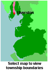
View maps of Ulverston and places within its boundaries.
View a map of the boundaries of this town/parish.
You can see maps centred on OS grid reference SD293778 (Lat/Lon: 54.191101, -3.085259), Ulverston which are provided by:
- OpenStreetMap
- Google Maps
- StreetMap (Current Ordnance Survey maps)
- Bing (was Multimap)
- Old Maps Online
- National Library of Scotland (Old Ordnance Survey maps)
- Vision of Britain (Click "Historical units & statistics" for administrative areas.)
- English Jurisdictions in 1851 (Unfortunately the LDS have removed the facility to enable us to specify a starting location, you will need to search yourself on their map.)
- Magic (Geographic information) (Click + on map if it doesn't show)
- GeoHack (Links to on-line maps and location specific services.)
- All places within the same township/parish shown on an Openstreetmap map.
- Nearby townships/parishes shown on an Openstreetmap map.
- Nearby places shown on an Openstreetmap map.
The Workhouse site has an interesting description of Ulverston workhouse.
For probate purposes prior to 1858, Ulverston was in the Archdeaconry of Richmond, in the Diocese of Chester. The original Lancashire wills for the Archdeaconry of Richmond are held at the Lancashire Record Office.
The Ulverston Heritage Centre is a charitable organisation, dedicated to the preservation, restoration and public use of a wide range of artefacts, documents and pictures.
You can also see Family History Societies covering the nearby area, plotted on a map. This facility is being developed, and is awaiting societies to enter information about the places they cover.