
Hide
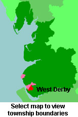
West Derby
hide
Hide
hide
Hide
hide
Hide
Hide
DERBY (West), a village, a parish, a sub-district, a district, and a hundred in Lancashire. The village stands 2 miles N by W of Broad-Green r. station, and 4 ENE of Liverpool post office; has a post office under Liverpool; and had a castle before the Conquest. The parish includes also Kensington, Stanley, Knotty-Ash, and other hamlets, and part of the borough and suburbs of Liverpool; contains a botanic garden, a zoological garden, a lunatic asylum, and a large industrial school; and was only a chapelry of Walton-on-the-Hill till 1847. Acres, 6,123. Rated property, £232,783. Pop. in 1841, 16,864; in 1861, 52,694. Houses, 9,239. Pop. of the portion within Liverpool borough, in 1841. 9,760: in 1861, 36,527. Houses, 6,378. The property is much subdivided. The living is a rectory in the diocese of Chester. Value, £1,300. Patron, the Rev. J. Stewart. The vicarages of Fairfield and St. Catherine, and the p. curacies of Stanley, Knotty-Ash, St. James, St. Jude, St. Stephen, and St. Mary are separate benefices. Value of St. Catherine, £230; of St. Ann, £78; of St. Jude and St. Mary, each £300; of St. Stephen, £300; of the others, not reported. Patrons of Fairfield, the Bushby family; of St. Catherine, St. John, St. Jude, and St. Stephen, Trustees; of Stanley, the Rev. T. Garner; of St. James, Mrs. Reade; of St. Mary, J. Stewart, Esq. more ...
John Marius Wilson, Imperial Gazetteer of England and Wales (1870-72)
Hide
Local studies information is held at Liverpool library.
Details about the census records, and indexes for West Derby.
The Register Office covering the West Derby area is Liverpool.
In registration districts for BMDs and censuses, the name Liverpool is applicable only to an area bounded by the river Mersey, Boundary Road, Great Homer St. and Upper Parliament street. All the rest of Liverpool is West Derby which is the name of the ancient Hundred ,An area which covered most of SW Lancs. It is also the name of a "village" now a suburb of Liverpool.
As the population grew parishes were split into smaller units. The same happened with registration districts so that Toxteth Park etc were split from West Derby.
The West Derby Union was established in 1837 for civil registration. Not included in the West Derby Union was Liverpool to the west, and Prescot to the east.
Forming that union were the following villages or townships.West Derby; Bootle; Everton; Fazakerley; Kirkby; Kirkdale; Walton on the Hill; Aintree; Great Crosby; Little Crosby; Inch Blundell; Litherland; Lunt; Netherland; Orrell and Ford; Sephton; Thornton; Toxteth Park; Childwall; Allerton; Garston; Wavertree; and Croxteth Park.
The National Gazetteer of Great Britain and Ireland - 1868
"KNOTTY ASH, a village within the borough of Liverpool, in the parish of Walton on the hill, hundred of West Derby, county Lancaster, 3 miles E. of Liverpool."
"WEST DERBY, a chapelry in the parish of Walton-on-the-Hill, in the county of Lancaster, 4 miles N.E. of Liverpool, and 4¼ W. of Prescot. It contains Kensington, Stanley, Knotty Ash, and other hamlets, including many handsome residences of the Liverpool merchants. Before the Conquest there was a castle here, which is mentioned in Domesday Survey as then in ruins. There are several district churches, the livings of which are perpetual curacies St. John the Evangelist, in the patronage of trustees; St. James, in that of Mrs. Thornton; St. Anne, in that of the Rev. T. Gardner; and St. Jude, Low Hill, value £300, in the patronage of trustees. This chapelry of late years, by reason of its proximity to Liverpool, Prescot, and Birkenhead, has vastly increased in population and wealth. The river Mersey and the Leeds canal are within a short distance.
"OLD SWAN, a chapelry in the parish of Walton-on-the-Hill, hundred of West Derby, county Lancaster, 3 miles E. of Liverpool. The village, which may be considered a suburb of Liverpool, contains the cattle market, and is the site of extensive glass works and roperies."
"FAIRFIELD, a village in the hundred of West Derby, county Lancaster, 2 miles N.E. of Liverpool; has a handsome church dedicated to St. John, and may be described as a "village of villa residences.""
"BROAD-GREEN, a village in the hundred of West Derby, in the county of Lancashire, 3 miles E. of Liverpool. The village, which is entirely modern, contains several pleasant villa residences."
John Marius Wilson, Imperial Gazetteer of England and Wales - 1870-2
- Ask for a calculation of the distance from West Derby to another place.
In 1835 West Derby was a township in the parish of Walton on the Hill.
West Derby was one of the eight hundreds of Lancashire, fifteen townships came under its durisdiction and its boundaries reached as far west as Moss St, Islington. Over the centuries it was in turn inhabited by the Danes, Anglo-Saxons, and until 13thC. stood in a forest 11 miles long/2 miles wide. It has had a Saxon fort, a Norman Fort and now a small walled garden marks the site. King John transferred the Wapentake court from West Derby, when he granted the Charter to L,pool in 1207. (the forerunner of the County Court today). Ecclesiastically West Derby was part of Walton Parish for many years, but became independent in 1848. The present parish church built 1853/4 (designed by Gilbert G Scott, replaced the ancient chapel of St Mary the Virgin.
View maps of West Derby and places within its boundaries.
View a map of the boundaries of this town/parish.
You can see maps centred on OS grid reference SJ395938 (Lat/Lon: 53.437215, -2.911478), West Derby which are provided by:
- OpenStreetMap
- Google Maps
- StreetMap (Current Ordnance Survey maps)
- Bing (was Multimap)
- Old Maps Online
- National Library of Scotland (Old Ordnance Survey maps)
- Vision of Britain (Click "Historical units & statistics" for administrative areas.)
- English Jurisdictions in 1851 (Unfortunately the LDS have removed the facility to enable us to specify a starting location, you will need to search yourself on their map.)
- Magic (Geographic information) (Click + on map if it doesn't show)
- GeoHack (Links to on-line maps and location specific services.)
- All places within the same township/parish shown on an Openstreetmap map.
- Nearby townships/parishes shown on an Openstreetmap map.
- Nearby places shown on an Openstreetmap map.
The Workhouse site has an interesting description of West Derby workhouse.
For probate purposes prior to 1858, West Derby was in the Archdeaconry of Chester, in the Diocese of Chester. The original Lancashire wills for the Archdeaconry of Chester are held at the Lancashire Record Office.
You can also see Family History Societies covering the nearby area, plotted on a map. This facility is being developed, and is awaiting societies to enter information about the places they cover.