
Hide
Amcotts
hide
Hide
hide
Hide
hide
Hide
Hide
Amcotts, township, Althorpe par., N. Lincolnshire, on river Trent, 5 miles NE. of Crowle, pop. 397.
From: John BARTHPLOMEW's "Gazetteer of the British Isles (1887)"
Hide
The Scunthorpe Central Library is an excellent resource with a Local History section.
- Amcotts was part of the Crowle sub-district of the Thorne Registration District (which is mostly in Yorkshire).
- The Lincolnshire Family History Society has published surname indexes on fiche or in booklet form for each of the census years under the title "Gainsborough with Isle of Axholme". These are available by credit card from the Federation of Family History Societies Bookstore with worldwide shipping. Please note that these are SURNAME indexes only, and do not show first names, age or relationships.
- Check our Census Resource page for county-wide resources.
- The table below gives census piece numbers, where known:
| Census Year | Piece No. |
|---|---|
| 1841 | H.O. 107 / 626 & 639 |
| 1851 | H.O. 107 / 2105 |
| 1881 | R.G. 11 / 4699 |
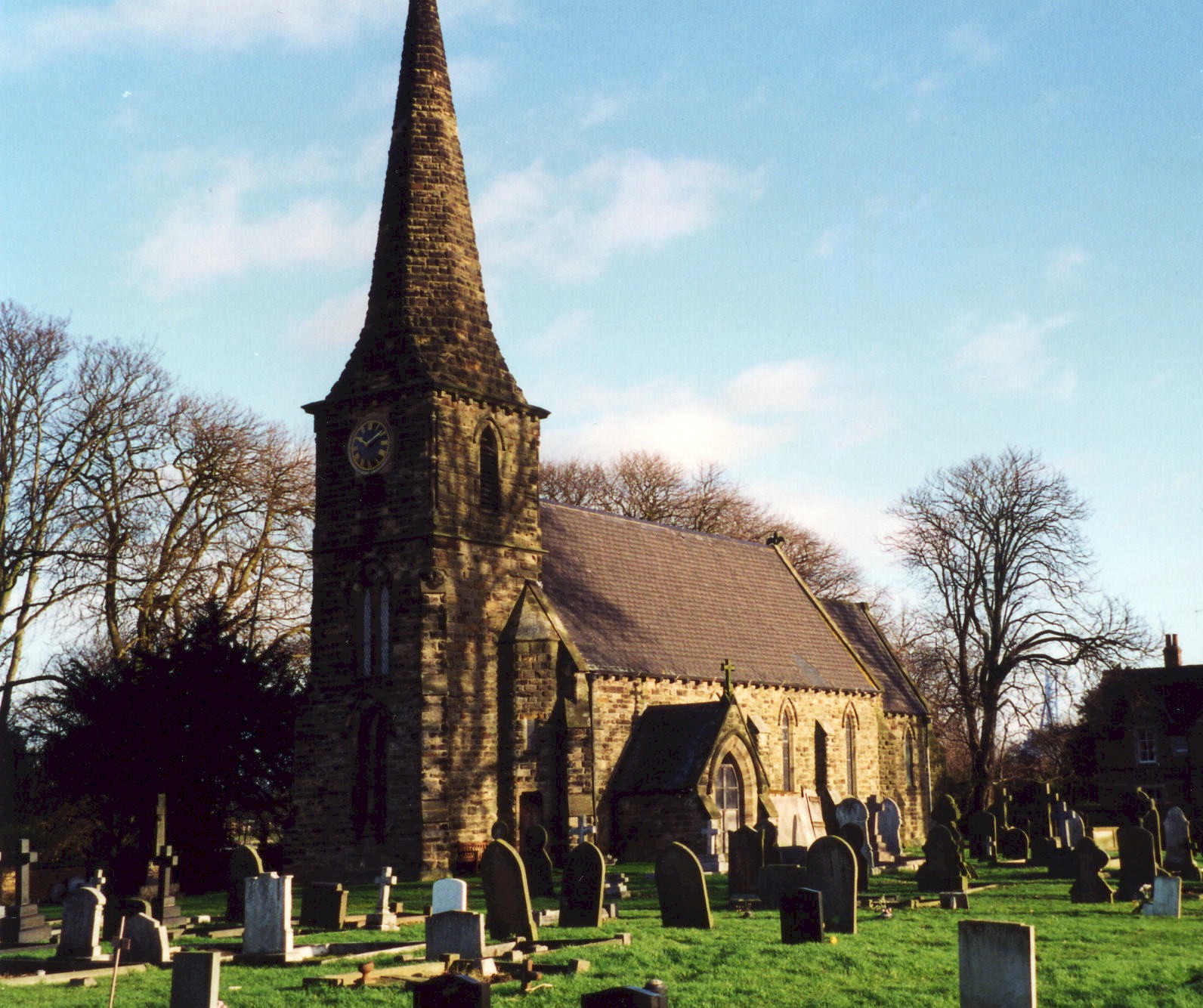
- Amcotts was a chapelry of Althorpe until 1850 and the chapel, dedicated to Saint Thomas á Becket, fell down from decay in 1850.
- The present Anglican church is dedicated to Saint Mark and was erected on the site of the chapelry in 1853.
- The church is built of stone.
- The church seats 180.
- David HITCHBORNE has a photograph of St. Mark's Church on Geo-graph, taken in July, 2004.
- Here is a photograph of St. Mark's Church supplied by Ron COLE (who retains the copyright):
- The Anglican parish register dates from 1836. Prior register entries will be found in Althorpe registers.
- The Lincoln Archives hold baptism records up until 1930 and marriages up to 1973.
- The Lincolnshire Family History Society has provided a marriage index for the Isle of Axholme Deanery to make your search easier.
- The Wesleyan Methodists built a chapel here in 1870 and a school in 1886. The village also had a chapel for the Primitive Methodists prior to 1930. For information and assistance in researching these chapels, see our non-conformist religions page.
- Check our Church Records page for county-wide resources.
- The parish was part of the Crowle sub-district of the Thorne Registration District (which is mostly in Yorkshire).
- Check our Civil Registration page for sources and background on Civil Registration which started in July, 1837.
Amcotts is a village, a township and a parish in the Isle of Axholme in the far northwest corner of Lincolnshire. See the histories and descriptions of Amcotts provided by the Isle of Axholme FHS.
Amcotts parish, formed in 1850 from part of Althorpe parish, sits inside a bend in the River Trent about 3 miles north of Althorpe village, 4 miles northwest of the conurbation of Scunthorpe and 7 miles east of Crowle. The parish of Flixborough lies across the River. It is primarily a rural parish, covering about 1,990 acres of flat moorland. If you are planning a visit:
- By automobile, the village is perhaps best reached off of the A18 trunk road to Althorpe, then north on the B1392 as it follows the banks of the River Trent. Once past Keadby, Amcotts village is next.
- For bus service and car hire sources, check our Transport page.
- See our touring page for area resources.
- Ask for a calculation of the distance from Amcotts to another place.
- See our Maps page for additional resources.
You can see maps centred on OS grid reference SE838147 (Lat/Lon: 53.622336, -0.734101), Amcotts which are provided by:
- OpenStreetMap
- Google Maps
- StreetMap (Current Ordnance Survey maps)
- Bing (was Multimap)
- Old Maps Online
- National Library of Scotland (Old Ordnance Survey maps)
- Vision of Britain (Click "Historical units & statistics" for administrative areas.)
- English Jurisdictions in 1851 (Unfortunately the LDS have removed the facility to enable us to specify a starting location, you will need to search yourself on their map.)
- Magic (Geographic information) (Click + on map if it doesn't show)
- GeoHack (Links to on-line maps and location specific services.)
- All places within the same township/parish shown on an Openstreetmap map.
- Nearby townships/parishes shown on an Openstreetmap map.
- Nearby places shown on an Openstreetmap map.
- In the churchyard is a Celtic cross made of Aberdeen granite. It was erected in 1921 in memory of the men from this village who fell in World War I.
- David WRIGHT has a photograph of the War Memorial on Geo-graph, taken in September, 2006.
For a photograph of the Amcotts War Memorial and the list of names on the plaque, see the Roll of Honour site.
- The meaning of the name Amcotts (also found as "Amcoates" in old records) is from the Old English Amma+cot, for "cottage of a man called Amma". In the 1086 Domesday Book it appeares as Amecotes.
A. D. MILLS, "A Dictionary of English Place-Names," Oxford University Press, 1991.
- The surnames AMCOTTS and AMCOATES are associated with the parish, although which came first is debatable. INGLEBY and BELTON are other surnames common to this parish.
- Amcotts parish was formed in 1850 from part of Althorpe parish. In prior years it was considered a township in Althorpe.
- The parish was in the ancient Manley Wapentake in the parts of Lindsey.
- In the 1972 redistricting, Amcotts became part of the Boothferry District, which is now in the County of Humberside (formerly Lindsey, Lincolnshire).
- District governance is currently provided by the North Lincolnshire Council.
- Bastardy cases would be heard in the Epworth petty session hearings.
- The parish became part of the Thorne Poor Law Union after the Poor Law Amendment Act of 1834.
- A school was built here in 1860.
- For more on researching school records, see our Schools Research page.
- The local genealogical society is the Isle of Axholme FHS.