
Hide
Ancaster
hide
Hide
hide
Hide
hide
Hide
Hide
hide
- Maps
- Migration, Internal◬
- Military History
- Military Records
- Monumental Inscriptions
- Names, Geographical
- Names, Personal◬
- Naturalisation & Citizenship◬
- Newspapers◬
- Nobility
- Occupations◬
- Politics & Government
- Poor Houses, Poor Law
- Population
- Postal & Shipping Guides◬
- Probate Records◬
- Public Records◬
- Schools
- Societies◬
- Voting Registers◬
Hide
Hide
The Library at Grantham will prove useful in your research.
- A Roman Cemetery with more than 300 adult burials was found adjacent to St. Martin's churchyard cemetery.
- The parish has a cemetery on Church Lane, behind the church.
- The parish was in the Grantham sub-district of the Grantham Registration District.
- Check our Census Resource page for county-wide resources.
- The table below gives census piece numbers, where known:
| Census Year | Piece No. |
|---|---|
| 1841 | H.O. 107 / 614 |
| 1851 | H.O. 107 / 2103 |
| 1861 | R.G. 9 / 2352 |
| 1871 | R.G. 10 / 3361 |
| 1891 | R.G. 12 / 2586 |
- At the Domesday survey (1068), Ancaster is not listed, but at West Willoughby there were two churches and a small hermit chapel.
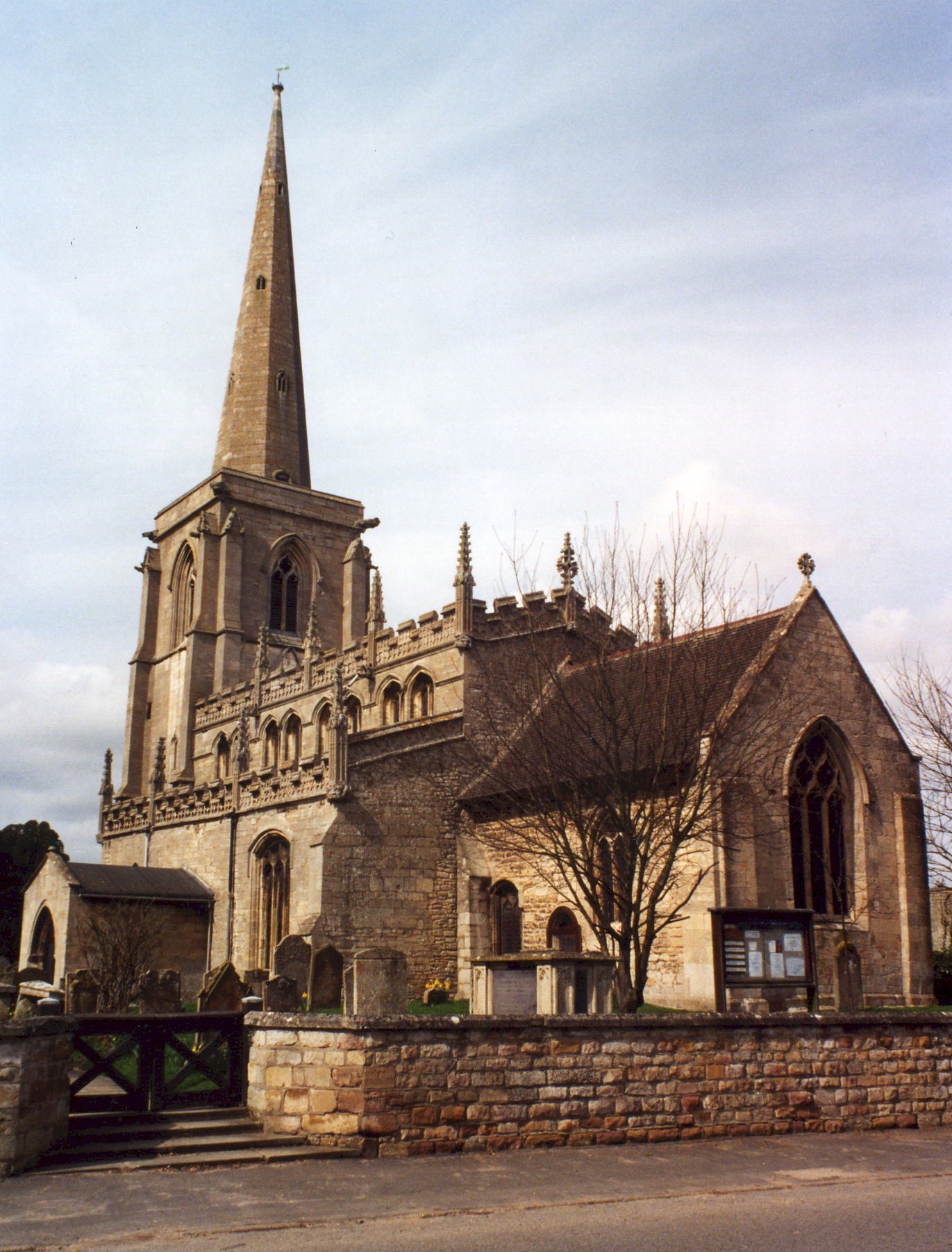
- The present Anglican parish church is dedicated to Saint Martin.
- The church is built from local Ancaster Stone, apparently during the Norman period. It stands on the site of a Roman temple, but the current building dates back to early Norman times.
- The tower was restored in 1912.
- The churchyard was closed to burials in May, 1909, except for existing family vaults.
- The church contains memorial windows donated by the PEMBERTON and LLOYD families, and monuments to the ALLIX family.
- The spire was repaired in 2007.
- The church seats 220.
- Gary BROTHWELL has a photograph of St. Martin's Church on Geo-graph, taken in September, 2010.
- Roger GEACH has a photograph of St. Martin's Church on Geo-graph, taken in March, 2010.
- Richard CROFT has a photograph of the church interior on Geo-graph, taken in November, 2005
. - Here is a photograph of St. Martin's Church supplied by Ron COLE (who retains the copyright):
- The churchyard was closed for burials in May 1909.
- The Anglican parish register dates from 1722, but Bishop's transcripts go back to 1562.
- Shelley CLACK has made a list of the monument inscriptions in the churchyard. You can download her "Ancaster Churchyard Portable Document file and search for your relatives.
- St. Martin's Church holds a list of clergy which goes back to 1236. (Thank you, Henny SHOTTER, Churchwarden.)
- The Lincolnshire FHS has a Loan Library service which has the parish registers on microfiche for Baptisms from 1722 to 1812 and Marriages from 1723 to 1812.
- The LFHS has published several indexes for the Loveden Deanery to make your search easier.
- The Primitive Methodists had a small chapel here, and at Sudbrook a United Methodist chapel, built in 1837. For information and assistance in researching these chapels, see our non-conformist religions page.
- Check our Church Records page for county-wide resources.
- The parish was in the Grantham sub-district of the Grantham Registration District.
- Check our Civil Registration page for sources and background on Civil Registration which began in July, 1837.
This village and parish lies just over seven miles north-east of Grantham and six miles west of Sleaford. The parish covers about 2,870 acres and includes the hamlets of Sudbrook and West Willoughby (both west of the village of Ancaster). Wilsford parish is just to the east, with Honington parish to the west and Barkston to the south-west.
North of the village, the B6403 (High Dike) is the dividing line between South and North Kesteven. The main road through the village is Ermine Street.
The village of Ancaster is east of the A607 trunk road at Honington. It has a train station, once a part of the Grantham, Sleaford and Boston branch of the Great Northern Railway. The houses on the east side of Ancaster village are in Wilsford parish. If you are planning a visit:
- Ancaster is at the intersection of the A153 west out of Sleaford and the B6403, the old Ermine Street, north out of Grantham.
- There is rail passenger service via the Nottingham-Skegness line.
- Marathon has a photograph of Ancaster Station on Geo-graph, taken in August, 2017.
- Ian S. has a photograph of The Ermine on Geo-graph, taken in June, 2012.
- The Ancaster Valley grasslands at SK 9843 are a preserve of the Lincolnshire Wildlife Trust.
- Visit our touring page for more sources.
- Ask for a calculation of the distance from Ancaster to another place.
- Ancaster can trace it's history through the Iron Age.
- At Ancaster, the Romans built a fort on the site of an existing settlement. This later developed into a small town which was provided with a town wall. In the field opposite the church, grass covered banks now mark the line of the Roman town wall and associated ditch. It is believed by many that the Romans called the place Causennae, but more recent research by Rivet disputes this. Many Roman coins have been found in the area, along with some skeletons dated to that era.
- The Romans also were great road-builders. Ermine Street linked London to the north and runs through the heart of the village. An old Roman milestone from the time of Constantine (306 - 324) for many years was kept at the vicarage, but now resides in the Grantham Museum. That museum also houses a carved Roman sculpture of the Deae Matres (three seated pregnant women), a Goddess of fertility. There were several carvings of Roman Gods and Godesses found in Ancaster. The last was an inscription, found by Time Team in 1999, to the elsewhere unknown God Viridius. (Thank you, Henny SHOTTER, Churchwarden)
- The village has the remains of a 14th century market cross (Grade II and Scheduled Monument) photographed by Alan MURRAY-RuST in November, 2014.
- In the 1580s/1590s, The Plague strikes Lincolnshire and checks population growth.
- In the 17th century, smaller market towns like Ancaster grew.
- Ancaster stone, oolite with a light reddish cast that hardens with exposure to the air, was quarried here. It was used in the construction of many Lincolnshire buildings. In 1913, the quarries were worked by LINDLEY and Son.
- The Mid-UK Recycling Plant is located just north of the village and has been the site of several recent fires.
- And check the Loveden Org website for local history.
- West Willoughby Hall was built of local Ancaster Stone. David FLINN reports: "On a visit to Willoughby Hall in the 1950s as a child, I remember the place being partially ruined. Sadly, it has been completely demolished since then."
- Alan MURRAY-RUST has a photograph of Ancaster Hall on Geo-graph, taken in November, 2014.
- See our Maps page for additional resources.
You can see maps centred on OS grid reference SK983436 (Lat/Lon: 52.98074, -0.537348), Ancaster which are provided by:
- OpenStreetMap
- Google Maps
- StreetMap (Current Ordnance Survey maps)
- Bing (was Multimap)
- Old Maps Online
- National Library of Scotland (Old Ordnance Survey maps)
- Vision of Britain (Click "Historical units & statistics" for administrative areas.)
- English Jurisdictions in 1851 (Unfortunately the LDS have removed the facility to enable us to specify a starting location, you will need to search yourself on their map.)
- Magic (Geographic information) (Click + on map if it doesn't show)
- GeoHack (Links to on-line maps and location specific services.)
- All places within the same township/parish shown on an Openstreetmap map.
- Nearby townships/parishes shown on an Openstreetmap map.
- Nearby places shown on an Openstreetmap map.
The southern end of the parish includes land that was part of RAF Barkston Heath.
Simon MORTIMER has a photograph of the end of the Runway at Barkston Heath on Geo-graph, taken in April, 2011.
For a photograph of the Ancaster War Memorial and the list of names on the plaque, see the Roll of Honour site.
There are two Commonwealth War Graves in Ancaster Cemetery; one for WWI and one for WWII:
- George BENTLEY, lance bombardier, 464 Bty. Royal Artillery, age 46, died 19 Apr. 1942. Husband of Ethel BENTLEY, Ancaster.
- J. E. PORTER, priv., 7th Btn. Lincs Regt., age 29, died 10 Jan. 1915.
Memorial to Elizabeth Long, St Martin's church, Ancaster: "Wife of Edward LONG, she died in 1743, aged 31. Also to her daughter Ann who died in her infancy." Made by Joshua LONG.
- The romans called this place Causennae.
- The name Ancaster is Old English Anna+caester, or "Roman fort of a man called Anna". The caester portion of the name derives from the Roman occupation of England. It is unclear as to the derivation of the name Anna. The parish is listed in the 12th century as Anecastre.
[A. D. MILLS, "A Dictionary of English Place-Names," Oxford University Press, 1991]
- Ancaster gave the title of Duke to the BERTIE family, but that line died out in 1809. The title of Earl of Ancaster was conferred in 1892 on Gilbert Henry, 22nd Baron Willoughby de ERESBY.
- This place was an ancient parish in Lincoln county and became a modern Civil Parish when those were established.
- The parish was in the ancient Loveden Wapentake in the South Kesteven district in the parts of Kesteven.
- Kelly's 1900 Directory of Lincolnshire reports, perhaps erroneously, that the parish is in the North Kesteven division of the county.
- You can contact the Parish Council regarding civic or political matters, but they are NOT staffed to assist with family history searches.
- Robert HARVEY has a photograph of the Village Hall on Geo-graph, taken in February, 2019. The Hall can be hired for family reunions.
- For today's district governance, contact the South Kesteven District Council.
- In 1773 the common fields were enclosed here. At that time, they were described as a wild and barren heath.
- PENNELL's charity provided £9 and 12 shillings yearly for fuel for the poor.
- Bastardy cases would be heard in the Sleaford petty session hearings.
- After the Poor Law Amendment Act reforms of 1834, the parish became part of the Grantham Poor Law Union.
Year Inhabitants 1801 336 1811 381 1821 439 1841 480 1851 589 1861 682 1871 646 1881 650 1891 600 1911 536 1921 789 1931 758
- A Public Elementary School was built here in 1862. It was enlarged to seat 145 children in 1883.
- The school, on Mercia Drive, has its own website under the new name of Ancaster C of E Primary School. Alas. there is no listing of old student logs online.
- For more on researching school records, see our Schools Research page.