
Hide
Bicker
hide
Hide
hide
Hide
hide
Hide
Hide
hide
Hide
Hide
The Library at Boston will prove useful in your research.
The Cemetery on the north end of the village appears to date from the early 20th century.
- The parish was in the Swineshead sub-district of the Boston Registration District.
- Check our Census Resource page for county-wide resources.
- We have an extract of a small portion of the 1891 Census. You may add your own findings by contacting the site coordinator.
- The table below gives census piece numbers, where known:
| Census Year | Piece No. |
|---|---|
| 1841 | H.O. 107 / 606 |
| 1851 | H.O. 107 / 2099 |
| 1861 | R.G. 9 / 2339 |
| 1871 | R.G. 10 / 3345 |
| 1891 | R.G. 12 / 2576 |
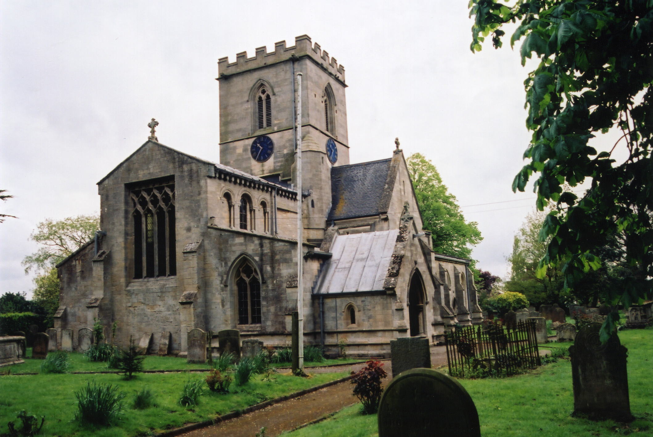
- The Anglican parish church is dedicated to Saint Swithin, apparently of Norman origin, although most of the current building dates from the Elizabethan period.
- The north portion of the church was restored in 1876.
- The south end of the church was restored in 1893-94.
- The church seats about 300.
- There is a photograph of St. Swithin's Church on the Wendy PARKINSON Church Photos web site.
- Geoff PICK has a photograph of St. Swithin's Church on Geo-graph, taken in May, 2003.
- Here is a photograph St. Swithin's Church supplied by Ron COLE (who retains the copyright):
- Anglican parish registers exist from 1561.
- We have a partial parish register extract for you to search. You may add your own findings by contacting the site coordinator.
- The Lincolnshire FHS has published several marriage indexes and a burial index for the Holland West Deanery to make your search easier.
- Check our Church Records page for county-wide resources.
- The parish once hosted a chapel for Wesleyan Methodists and Primitie Methodists, built in 1908.
- Richard CROFT has a photograph of the Primitive Methodist Chapel on Geo-graph, taken in February, 2008.
- For information and assistance in researching these chapels, see our non-conformist religions page.
- Check our Church Records page for county-wide resources.
- The parish was in the Swineshead sub-district of the Boston Registration District.
- Check our Civil Registration page for sources and background on Civil Registration which began in July, 1837.
Bicker is both a village and parish less than 2 miles northeast of Donington parish on the A52 trunk road as it heads up to Boston. The parish is just over 100 miles north of London. It is bounded on the north by Swineshead parish. The Hammond Beck forms a western boundary. The area is flat fenland, about 3,770 acres, drained by many small canals.
If you are planning a visit:
- The A52, locally known as Bicker Road, runs along the eastern edge of the village.
- The "Old Eau" stream or drain runs through the heart of the village. Jonathan THACKER has a photograph of the Old Eau on Geo-graph, taken in December, 2016.
- Visit our touring page for more sources.
- Ask for a calculation of the distance from Bicker to another place.
The Manor House dates from 1774.
Robert HARVEY has a photograph of the Manor House on Geo-graph, taken in March, 2015.
- See our Maps page for additional resources.
You can see maps centred on OS grid reference TF225375 (Lat/Lon: 52.920955, -0.179391), Bicker which are provided by:
- OpenStreetMap
- Google Maps
- StreetMap (Current Ordnance Survey maps)
- Bing (was Multimap)
- Old Maps Online
- National Library of Scotland (Old Ordnance Survey maps)
- Vision of Britain (Click "Historical units & statistics" for administrative areas.)
- English Jurisdictions in 1851 (Unfortunately the LDS have removed the facility to enable us to specify a starting location, you will need to search yourself on their map.)
- Magic (Geographic information) (Click + on map if it doesn't show)
- GeoHack (Links to on-line maps and location specific services.)
- All places within the same township/parish shown on an Openstreetmap map.
- Nearby townships/parishes shown on an Openstreetmap map.
- Nearby places shown on an Openstreetmap map.
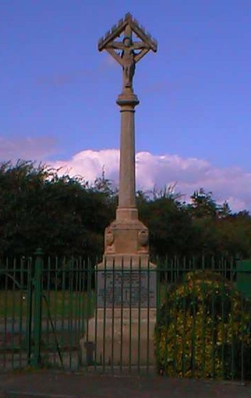
- Richard CROFT has a photograph of the War Memorial on Geo-graph, taken in February, 2008.
John Emerson, who retains the copyright, provides this photograph of the war memorial at Bicker:
On Caythorpe Road, between Bicker and Donington, is the crash site for Avro Lancaster Bomber Mk. III, ND820, wich crashed on 10th. April 1944. It was a new aircraft with only 6 hours of recorded flight time. All seven men aboard were killed. A Cairn was raised at the site.
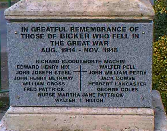
From the Bicker War Memorial by John Emerson (The names have been sorted for your convenience). The spelling of the word "greatful" on the first line is how it is spelt on the memorial:
In greatful remembrance of those of Bicker who fell in the Great War Aug 1914 - Nov 1918.
|
|
|
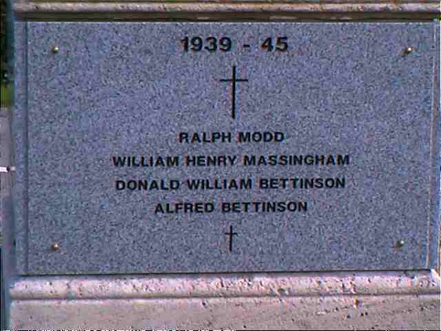
1939 - 45:
| Alfred BETTINSON | William Henry MASSINGHAM |
| Donald William BETTINSON | Ralph MODD |
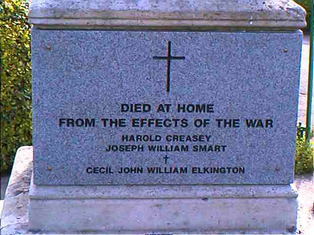
It is not clear in which war the following died, the inscription reads:
Died at home from the effects of the war:
| Harold CREASEY |
| Cecil John William ELKINGTON |
| Joseph William SMART |
John Emerson, who retains the copyright, provides these photographs of the war memorial plaques at Bicker:
- The name Bicker is from the Old Scandinavian by+kjarr, or "village marsh". In the 1086 Domesday Book, the village is given as Bichere.
[A. D. MILLS, "A Dictionary of English Place-Names," Oxford University Press, 1991]
- The parish was in the ancient Kirton Wapentake in the Boston Borough in the parts of Holland.
- Kelly's 1900 Directory of Lincolnshire places the parish, perhaps erroneously, in the North Kesteven division of the county.
- Robert HARVEY has a photograph of the Village Hall (just north of the village) on Geo-graph, taken in March, 2015.
- You may contact the local Parish Council regarding civic or political issues, but they will NOT do family history searches for you.
- For today's district governance, visit the local Boston Borough Council.
- Bastardy cases would be heard in the Kirton and Skirbeck petty session hearings.
- Thomas DICKENSON left £10 in 1652 for the poor.
- William THOMPSON left £52 in 1686 for the poor.
- The CUST family left £26, undated, for the poor.
- As a result of the 1834 Poor Law Amendment Act, this parish became part of the Boston Poor Law Union.
- The Public Elementary School was built to hold 150 children.
- For more on researching school records, see our Schools Research page.