
Hide
Boston
hide
Hide
hide
Hide
hide
Hide
Hide
hide
- Medical Records
- Migration, Internal◬
- Military History
- Military Records
- Names, Geographical
- Names, Personal
- Naturalisation & Citizenship◬
- Newspapers
- Occupations
- Officials & Employees
- Politics & Government
- Poor Houses, Poor Law
- Population
- Postal & Shipping Guides◬
- Probate Records◬
- Public Records◬
- Schools
- Societies◬
- Voting Registers
Hide
Hide
The Boston Library is part of the Lincolnshire Library system and is located in the Town Hall building. It is open six days each week most weeks and has a Local History and Family History section to assist you with your searches. It is about one block from St. Botolph's Church. The building has ramp access for the handicapped. The Library has free and fast Internet Access for all card-holders.
- Boston Public Library
- County Hall
- Boston, PE20 1QJ
- Tele: 01522 782010
David HALLAM-JONES has a photograph of the Public Library, Boston on Geo-graph, taken in October, 2014.
There is a new footbridge over the River WItham that makes foor-traveller access to St. Botolph's and the Library even easier. David P. HOWARD has a photograph of the St. Botolph Footbrige on Geo-graph, taken in March, 2015.
Boston Guildhall is a beautiful medieval building, built in 1390 by the Guild of St Mary, which houses a museum added in 1929. They invite you to uncover Boston’s intriguing history, learn all about its links with America and Australia. The Guildhall is on South Street, just east of the River Witham.
These books may also help:
- "The Book of Boston" by Neil R. WRIGHT, publ. by Barracuda Books, 136 pages, ISBN: 08602-32654.
- "The History and Antiquities of Boston" by Pishey THOMPSON, 1856.
- "Boston, Its Story and People" by Geo. S. BAGLEY, 1986.
- "Floreat Bostona - the history of Boston Grammar School" by Geo. S. BAGLEY, 1985.
- The Boston Cemetery was laid out in 1855 as 12 acres on the side of the Maud Foster Drain, 1 mile north of town. In 1885 an additional 7 acres was added on the west side.
- The Boston Cemetery was managed by the Boston Burial Board. Most other burial grounds were closed by 1871 except for the Baptist Burial Ground in the Fen belonging to the High Street chapel.
- The Boston Cemetery Register 1855 - 1899 is published by the Lincolnshire Family History Society.
- More details about Boston Cemetery are available at Boston Crematorium.
- Fosdyke cemetery, opened in 1952, is also maintained by Boston Borough Council. [Pam Downes]
| Holy Trinity, Boston, Church of England |
| St Botolph, Boston, Church of England |
| St Thomas, Boston, Church of England |
| Spayne Lane, Boston, Unitarian |
- The parish was in the Boston sub-district of the Boston Registration District.
- For the 1851 census there is a street index for the Boston Registration district. Check your local Family History Library or the Lincolnshire Archives for a copy.
- For the 1861 census there were a number of Irish labourers in town. Here's a list of the surnames found on North Street: COYN, MURRY, FLANNAGAN, M'CAIN, DONLY, O'HARE, M'CAIN, M'GUIRE, RILLEY, BRENMAN, MATTHEWS, BROWN, JENBY, PADLEM, HUGGINS, CLARK, HIGGINS, CALLABY, FOX.
- The The Lincolnshire Family History Society has published surname indexes on fiche or in booklet form for each of these census years under the title "Boston". These are available by credit card from the Federation of Family History Societies Bookstore with worldwide shipping. Please note that these are SURNAME indexes only, and do not show first names, age or relationships.
- Check our Census Research page for county-wide resources.
- The table below gives census piece numbers, where known:
| Census Year | LDS Film/Fiche No. | Piece Numbers | LFHS Surname Index |
|---|---|---|---|
| 1841 | 0438755 | H.O. 107/613 | Fiche |
| 1851 | 0087727 & 0087728 | H.O. 107/2098 to 2099 | Booklet |
| 1861 | 0542955 & 0542956 | R.G. 9/2330-2338 | Fiche |
| 1871 | 0839353 through 0839355 | R.G. 10 / 3337 & 3339 - 3344 | Booklet |
| 1881 | 1341766 & 1341767 | R.G. 11/3212-3219 | |
| 1891 | 6097683, 3 fiche | R.G. 12/2573 | Booklet or Fiche |
| 1891 | 6097684, 3 fiche | R.G. 12/2574 | |
| 1891 | 6097685, 4 fiche | R.G. 12/2575 |
- Check our 1891 Partial Census Extract.
| Ebenezer, Boston, Baptist (Particular) |
| High Street, Boston, Baptist (General) |
| Salem, Boston, Baptist (Particular) |
| Grove Street/Cheyney Street, Boston, Congregationalist |
| London Road, Wyberton, Boston, United Reformed Church |
| Red Lion Street, Boston, Congregationalist |
| Spayne Lane, Boston, Unitarian |
| St Mary, Boston, Roman Catholic |
- The Anglo-Saxon Saint Botolph founded a monastery here around 650. It stood on the northern side of the present church. This was destroyed by the Danes in 870.
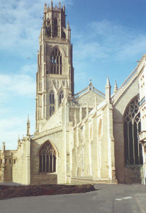
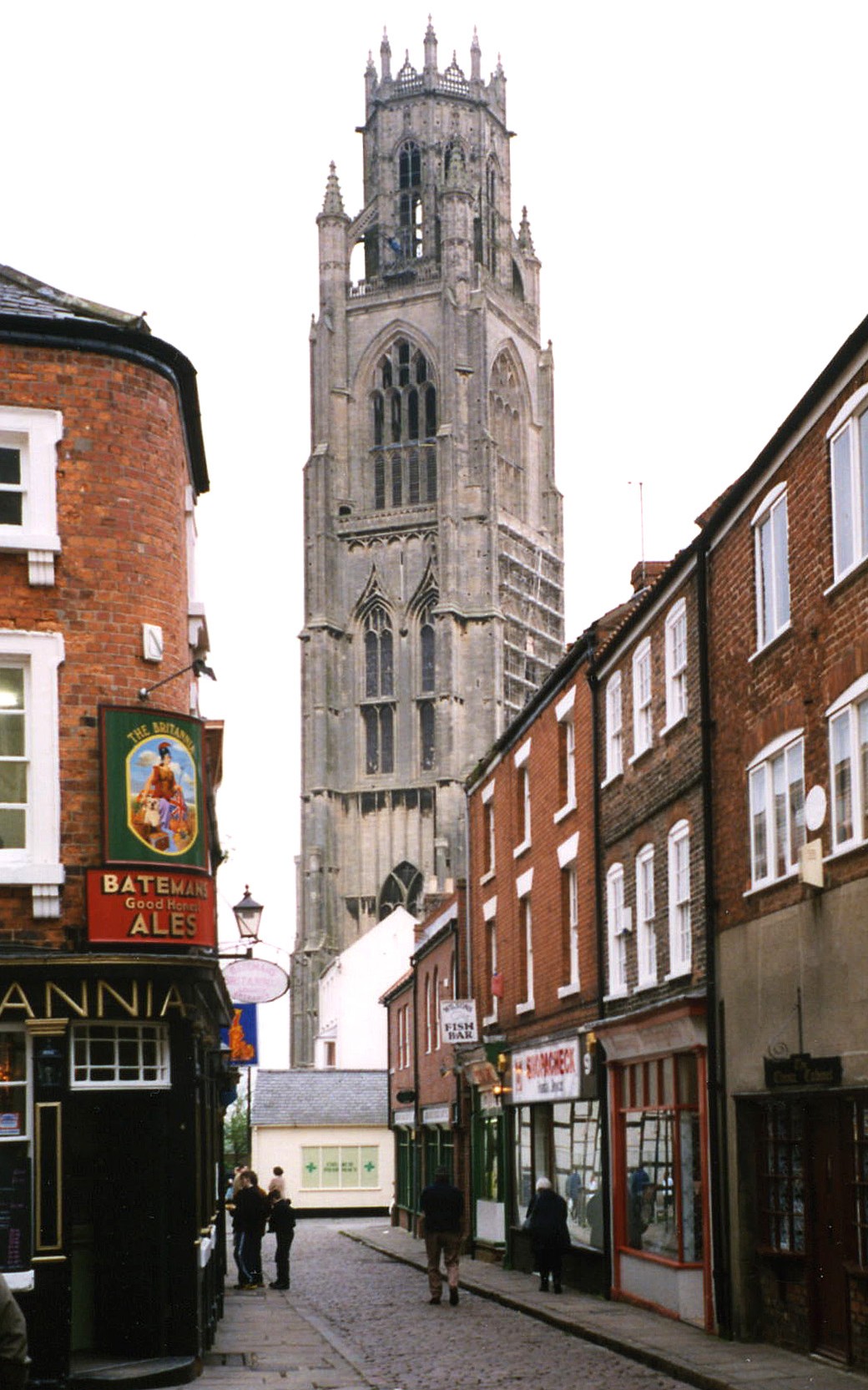
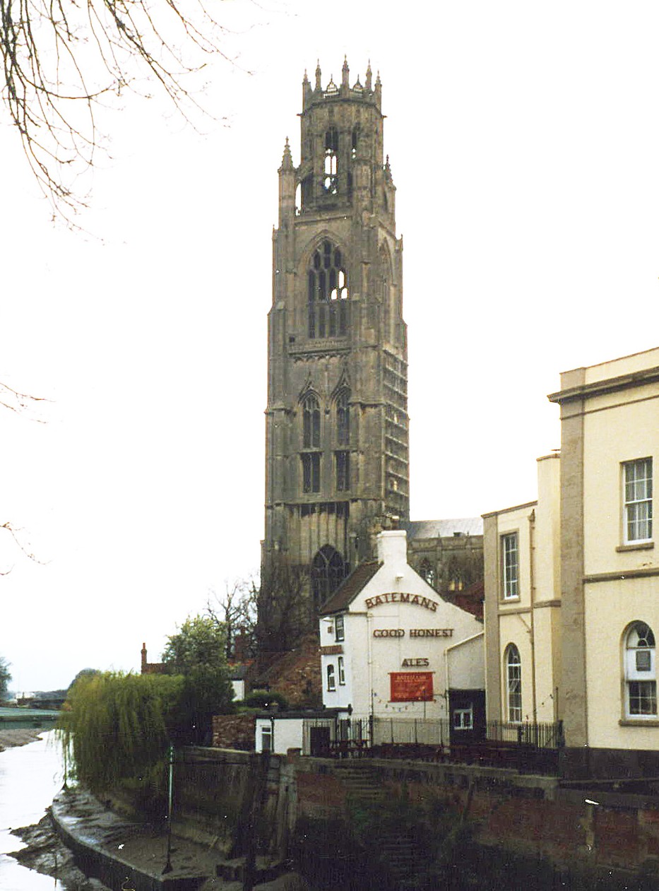
- The Anglican parish church is, of course, St. Botolph's. The church was begun in 1309 and was built on a grand scale to demonstrate Boston's wealth as a seaport town. It took over two centuries to complete the church building. The church now sports a small gift shop inside which sells a pamphlet, "Why Boston Stump? A Ten Minute Guide to Boston Parish Church," publ. 1978, for around 30 pence.
- The church is large enough to seat 1,775.
- Saint Aiden's church was located on High Street. It was a Chapel of Ease for St. Botolph's (Boston Stump) and was built of brick in 1821-2. Although renovated in 1908, it was demolished in the 1940s. There was some type of controversy from the pulpit in the 1920s and it closed at the end of a service.
- Saint James' Church was established in George Street, also as a Chapel of Ease. The church opened on 24 Aug. 1864. It was to serve the heavily built-up working class residential area which sprang up with the arrival of the railway. The foundation stone was laid on St James' day, 25 July 1864, by John Jackson, Bishop of Lincoln, and his successor, Edward King, performed the consecration thirteen months later. This church closed on 1 Jan. 1970 and the site was cleared for a supermarket in November of that year. Simon MEEDS, 2002
- The Catholic church was dedicated to Saint Mary and is on the Horncastle Road (now the B1183 arterial road). It was built in 1826. The church seats about 160. For information and assistance in researching these chapels, see our non-conformist religions page.
- There is a photograph of St. Botolph's church on the Wendy PARKINSON Church Photos web site.
- There are two photographs of St. Botolph's church on the Simon MEED web site.
- And the second is at Simon MEED's 2.
- Here is a photo of the St Botolph's Church, taken by (and copyright of) Norma CLARE.
- Here are two photos of the church, taken by Ron COLE (who retains the copyright):
- The Anglican parish register dates from 1557 for baptisms, 1564 for marriages and 1559 for burials.
- The register for St. Aiden's dates from 1822.
- St. Botolph's Burial Register (1813-1837) is available on four microfiche from the Federation of Family History Societies Bookstore, which allows purchased by credit card.
- The LFHS has published several indexes for the Holland East Deanery to make your search easier.
- Parish registers are now on file at the Society of Genealogists, covering 1557 - 1638. Check their site for other local churches, also.
- Lincoln Archives have St. James baptisms for 1893 - 1967. No marriages nor burials.
- The Lincoln Family History Society has a Marriage Index for Boston St Botolph 1813-1837 (revised) on 2 microfiche.
- We have a partial parish register extract. Your additions to this are welcome.
- The town has a long history of non-conformist religions, including Baptists, Catholics, Society of Friends and Wesleyan Methodists. The General Baptist Chapel was built on the High Street in 1763, then was taken down and rebuilt in 1837, then enlarged in 1841. The Particular Baptist Chepel on Liquorpod Street was built in 1810 and rebuilt in 1839. The Wesleyan Centenary Chapel in Redlion Street was built in 1840 to replace a smaller chapel on the same street built in 1807.
- The Congregational church used to be in Red Lion Street (almost opposite the Centenary Methodist Church) until sometime in the 1970's when the building was sold and then demolished. The church then met in premises used by the Unitarian Church in Spayne Lane. See also our extract from "Boston, Its Story and People". For information and assistance in researching these chapels, see our non-conformist religions page.
- One oddity is that the town had an iron church, which locals called "The Tin Tabernacle". The dates and dedication are unreported. [Tim Sylvester].
- Check our Church Records page for county-wide resources.
- The parish was in the Boston sub-district of the Boston Registration District.
- Check our Civil Registration page for sources and background on Civil Registration which began in July, 1837.
From 1552, Bostonians used to have their jail near the Stump. This is likely to be where the Scrooby Pilgrims were imprisoned in 1607.
Boston is both a parish and a town near the east coast of Lincolnshire. The River Witham turns south-east and runs through Boston to the sea at Black Buoy Sand. The parish of Boston is surrounded by Skirbeck parish on the east and south, with Wyberton and Brothertoft to the west and Langriville and a portion of Sibsey to the north. Boston parish comprises most of the old town of Boston. Due to the drainage of the Fens and population growth in the area, parish boundaries have been changed over the centuries. New parishes were added in the area in the late 1800's. In 1932, civil and parish boundaries were changed and are no longer the same for each jurisdiction, so no two maps will show the same boundaries.
The town of Boston lies near "The Wash", an inlet of the North Sea on Lincolnshire's southeast coast. The Wash is notorious for its sandbars and shallows.
Boston was a market town and sea port. The town is dominated by the 282-foot-high tower of St. Botolph's parish church (some sources say 272-foot-high). The tower (and not the church) is called "The Stump" by local fishermen who use it as a navigation beacon, but the term is sometimes used by others to include the church as well. If you are planning a visit:
- Visitors should start at Boston, UK.
- Boston lies at the intersection of the A52 and the A16 trunk roads and the A17 passes the Borough only a few miles to the south and west. There is good road access from south Yorkshire and the whole of the Midlands and from East Anglia. Regular rail services run through to the East Midlands with connections at Grantham to the East Coast Main Line.
- The Greenwich Meridian runs through Boston. For more background information, check the Website of the Greenwich Meridian (a bit slow to load with all the graphics).
- Visit our touring page for more sources.
- Ask for a calculation of the distance from Boston to another place.
Tim Sylvester tells us (in 2002):
There have been many works on the Witham, from Roman times to the modern period. In an Atlas for Boston - Frank Molyneux and Neil Wright, p36 it is recorded that the area of Boston known as "Old River Bed" holds 74 acres. I believe this description resulted from the enclosure of land relating to the old course of the River Witham, which was substantially altered to improve navigations and drainage between Boston and Lincoln. The Witham Drainage Act was approved in 1761. The proud boastings of Boston's corporations before the opening of the Grand Sluice at Boston as part of the scheme drove one disappointed visitor of the opening ceremony to verse following the ceremony:
"Boston, Boston, Boston!
Thou has naught to boast on,
But a Grand Sluice, and a high steeple;
A proud, conceited, ignorant people
And a cost (sic) where souls are lost on."
- The Romans apparently had a fort at the mouth of the river near this town.
- Boston received its first charter in 1204 from King John.
- The Hanseatic merchants had a house in Boston around 1259.
- In 1281 a fire devastated the town, and in 1286 it was flooded. In 1287 it was burned again, this time by Robert CHAMBERLAYNE. Chamberlayne was later hanged, but his confederates escaped.
- In 1369 Boston became the centre for wool trade in England.
- Shodfriars Hall on South Street is a 15th-century timber-framed building. For more on its past, see Shodfriars Hall.
- Boston was incorporated as a Borough by Henry VIII in 1546.
- The Plague struck Boston in 1585, 1588, 1603 and 1625.
- In 1607, a group of pilgrims from Nottinghamshire led by William BREWSTER and William BradfordRADFORD attempted to escape pressure to conform with the teaching of the English church by going to the Netherlands from Boston. At that time, unsanctioned emigration was illegal, and they were brought before the court in the Guildhall. Most of the pilgrims were released fairly soon, and the following year, set sail for the Netherlands, settling in Leiden. In 1620, several of these were among the group who moved to New England in the Mayflower.
- In 1634 the remaining Pilgrims set sail on the Griffin for the New World.
- During the period 1764 to 1766 the River Witham was dredged and made navigable again from Lincoln to Boston.
- In the 1800s, Boston had a high proportion of immigrants in its population.
- Although he was born in nearby Aswarby, there is a memorial in Boston to George BASS (1771-1803) an explorer, naval surgeon and naturalist who made Boston his home.
- In 1803 Howden's Foundry at Boston starts operations. It will later produce one of the first steam threshing machines.
- On 1 October 1848, the Great Northern Railway first reached Boston when the line from Firsby was opened. It soon expanded to include links with Peterborough, Sleaford and Lincoln.
- Around 1870, the trading vessel Cuirassier, a steamer, made weekly commerce trips between Boston and Hull.
- In 1911 some 439 men and boys were working the fishing trade out of Boston.
- For more on Boston's history, click on Boston, UK.
- See the names from the brochure "A short History of Boston, the Parish Church and some of the interesting people who have been associated with the town" (1977), extracted by Tom Miller.
- The Family History Library (FHL) in Salt Lake City has a number of books on the history of Boston under the call numbers 942.53. Only one of these is on microfilm and that is Pishey Thompson's "Collections for a topographical and historical account of Boston" under film no. 990118, item 4.
There is also this pamphlet series:
- "History of Boston" published by Richard KAY, 1976. Number 14, for example, by S. N. DAVIS, focuses on "Banking in Boston" and the GEE and the GARFIT families.
- Check the surnames listed on our 1874 Conveyance of an Estate.
- See our Maps page for additional resources.
You can see maps centred on OS grid reference TF331443 (Lat/Lon: 52.979526, -0.019036), Boston which are provided by:
- OpenStreetMap
- Google Maps
- StreetMap (Current Ordnance Survey maps)
- Bing (was Multimap)
- Old Maps Online
- National Library of Scotland (Old Ordnance Survey maps)
- Vision of Britain (Click "Historical units & statistics" for administrative areas.)
- English Jurisdictions in 1851 (Unfortunately the LDS have removed the facility to enable us to specify a starting location, you will need to search yourself on their map.)
- Magic (Geographic information) (Click + on map if it doesn't show)
- GeoHack (Links to on-line maps and location specific services.)
- All places within the same township/parish shown on an Openstreetmap map.
- Nearby townships/parishes shown on an Openstreetmap map.
- Nearby places shown on an Openstreetmap map.
- Boston Hospital was established in 1871 on the south bank of the River Witham as a cottage hospital, but was replaced with a larger building in 1874. A new wing was added in 1887.
- Pilgrim Hospital Boston is a National Health Service Hospital built just off of Sibsey Road, Boston.
- The author does not know what records have been retained. Hospitals were not required to archive their records.
- The 1st Lincolnshire Battery of the 1st North Midland Brigade of the Royal Field Artillery Territorial Force was formed here in 1860. It is presumed that this is the same unit as listed below. In 1871 it was called the Boston Artillery Volunteer Corps (1st Lincolnshire) and consisted of two batteries and a brass band.
- The Boston Rifle Volunteer Corps (4th Lincolnshire) was formed also in 1860.
- In 1882, the 1st Lincolnshire Voluntary Artillery had their drill hall on Main Ridge. Captains W. H. WHITE and F. STANWELL and lieut. Hy. SNAITH were the officers.
- In 1900, the 1st Lincolnshire Voluntary Artillery, Western Division, 1st Battery, had their drill hall in Main ridge. Captain WIlliam Henry GANE, commanding; Frank MARTIN, captain; Sergt.-Major Richard PLAISTER was the drill instructor.
- In 1913, the 1st Lincolnshire Battery had its Drill Hall at Main ridge. Second Lieut. Oswald B. GILES, commanding; Major Walter Geo. B. DICKENSON, veterinary officer; Battery-Sergt.-Majors Charles PARTNER and Samuel ASHER were the drill instructors.
- C Company of the 4th Territorial Force Battalion of the Lincolnshire Regiment was formed here in 1860. It is presumed that this is the same unit as listed below.
- In 1871, the Boston Rifle Volunteer Corps, (4th Lincolnshire) had their headquarters in High Street and their shooting range at Slippery Gowt Marsh. William GEE, captain, commanding; John J. JEBB, lieutenant, George WISE, ensign; Segt. John O'NEIL, drill instructor.
- In 1882, the Boston Rifle Volunteer Corps, C Company (2nd Lincolnshire) had their headquarters in High Street.
- In 1900, the 2nd Voluntary Battalion, Lincolnshire Regiment, Company C, had their headquarters in the Corn Exchange on the Market Place. Colour-Sergt. Alfred BROWN was the drill instructor.
- In 1913, Company C had their shooting range at Slippery Gowt marsh. Captain Meaburn STANILAND, commanding; Sergt.-Instructor Samuel STEPHENS, drill instructor.
- During the First World War, many of the town's trawlermen, together with those from Grimsby, were taken prisoner after their ships were sunk by German raiders in the North Sea. Their families did not know what had happened to them until late September 1914. The men were taken to Sennelager camp, then on to Ruhleben POW camp, where most remained until repatriated in 1918. A full report of their homecoming is in the Lincolnshire Standard newspaper, January 1918. Meanwhile, the port was used by hospital ships and some 4,000 sick or wounded troops passed through Boston. The town received bombing by a Zeppelin on 2 September 1916 when one of the bombs injured three adults and killed a child.
- In World War II, after Dunkirk, local defense was provided by the 6th Battalion of the Queens Regiment.
- There is a World War II pillbox in Boston, photographed by Richard CROFT.
- And David HITCHBORNE has another photograph of a pillbox in Boston, on Geo-graph, taken in September, 2013.
- Naturally, Boston got bombed during WW II. Read Paul Mould's Wartime Schooldays in Boston, copied from his website by Simon MEEDS.
- In World War II, around the time of Normandy, the 1st Air Landing Light Regiment of the Royal Artillery was posted here.
- To see photographs of the War Memorials, click on the Boston War Memorials page link.
- Another lad from Boston was Charles LAWRENCE, who died age 31 on 7 Feb. 1917 when the Hull trawler "Shakespeare" was sunk by a German U-boat just off Hull.
- Douglas Merson STEEL was on the HMS Hood when it was sunk in 1941. There is a good Bio. of him at the HMS Hood site. [Simon Meeds, 2012]
- The name Boston derives from Botulue+stan, which means a stone marker of a man named Botwulf. But one notices the similarity to Saint Botolph in the ancient name.
[A. D. MILLS, "A Dictionary of English Place-Names," Oxford University Press, 1991]
- "Boston" is not mentioned in the 1086 Domesday Book,
- This Boston is indeed the source for the name of the same city in Massachusetts. The Pilgrim fathers were imprisoned in Boston for a short period and left here on their journey to the New World.
- Boston folk, particularly seafarers, would use the term "down below" to refer to a trip to The Wash. [Farne HUNT, 2002].
- Click to see the text file: Bailey's British Merchant's and Trader's Useful Companion for 1784 list of names. [Mark in Barcelona]
- Boston used to be the home of the "Labourer" in the 1870s. Some issues may be at the Boston Library or Colindale (see below).
- The Boston Standard (previously Lincolnshire Standard) is a weekly newspaper based in the town, founded in the 19th century. It has been the main newspaper for Boston.
- The Boston Target is another weekly newspaper based in the town. The paper is owned by Local World.
- Check out the Newspapers page for more sources.
- The Boston Freemen and Apprentices Registers (1545-1903) have been published on microfiche by the Lincolnshire Family History Society.
- Boston's oldest bank, which outlived all its later Boston rivals, became known as Garfit, Claypon and Company twenty years after its formation in 1774, when Bartholomew CLAYPON was taken into partnership.
- John BRACKENBURY was mayor of Boston in 1719. Mr. William T. SIMONDS was the Mayor in 1902.
Caution: due to the drainage of the Fens and population growth in the area, parish boundaries have been changed. New parishes were added in the area in the late 1800's. In 1932, civil and parish boundaries were changed and are no longer the same for each jurisdiction, so no two maps will show the same boundaries.
- Boston was an ancient parish in Lincoln county and it became a modern Civil Parish when those were established.
- Boston was incorporated as a borough in May 1545 by Henry VIII.
- The parish was in the ancient Skirbeck Wapentake in the parts of Holland.
- The Civil Parish's boundaries were extended by 1,750 acres to include the whole of Skirbeck Quarter and much of Skirbeck on 1 April 1932. Although at the same time, Boston Civil Parish gave up about 1,200 acres to Brothertoft and Fishtoft Civil Parishes.
- For today's district governance, visit the local Boston Borough Council.
- Pam DOWNS tells us:
Skirbeck Quarter is part of Boston. Just to confuse matters there is also the parish of Skirbeck. Skirbeck is generally north and east of the river Witham. Skirbeck Quarter is south and west.
As you left Boston in the old days, heading south towards Spalding, Peterborough and London, you would travel down High Street, which then became London Road. At this point there are houses along only one side of the road, as the river is immediately on the other side. London Road runs along the river for about a 1/3rd of a mile, when the river does a 90-degree left turn towards the Wash.
The road area, at the junction with what was originally Rowell Row and which since September 1936 is Wyberton Low Road, is called Newtons Corner. There used to be almhouses there, but they were demolished around 1960 - 1970. A baker's shop has been across the road from where the almhouses were for at least 50 years, and there also used to be a corn merchants a few doors along in the 1950s.
- A parish workhouse was built in 1726 in a pasture next to St. John's Row. It replaced the earlier workhouse established in 1601.
- As a result of the 1834 Poor Law Amendment Act, Boston was chosen as the regional centre for the Boston Poor Law Union.
- Bastardy cases would be heard in the Sessions House on the north side of the church every Wednesday.
- We also have a short file of Bastardy Cases as found in the newspaper, "The Lincolnshire, Rutland and Stamford Mercury".
- The Muster Roll Houses, off the Skirbeck road, were for nine aged seamen and widows who lived there rent-free. Established in 1846 and funded from the Merchant Seaman's Fund they were still in operation in 1913.
- David BEVIS has a photograph of the Willoughby Road almshouses on Geo-graph, taken in 2012.
Boston flourished in the 1800s. The statistics below will include the officers and inmates in the Poor Law Workhouse:
Year Inhabitants 1801 5,926 1831 11,240 1851 15,132 1871 15,144 1881 14,926 1911 16,673
Boston has an ancient tradition as a centre of learning:
- Boston had a school as early as 1329, and probably even earlier. It seems that this early school was connected with the local guilds. [Simon MEEDS]
- The Free Grammar School was erected in 1567. Visit the official web pages of the Old Bostonian Association (association of ex-students and staff of Boston Grammar School), including some historical bits and pieces.
- The Laughton Endowed School was founded in 1707.
- A Blue Coat School was founded here in 1713.
- Boston National Schools were built in 1849.
- Read about the Boston Middle Girls' School as documented by Pat ASHBERRY in 2002.
- St Bede's Catholic School is a more recent structure, built as a secondary school sometime around 1970 for pupils aged 11 - 16.
- Boston College has two large campuses in Boston as well as a centre for Performing Arts and an Information and Cybercentre in the middle of town. The College has information and training centres in Spalding and Sleaford. Basic computer skills are offered at centres in Mablethorpe and Market Deeping.
- In World War II, Boston received a number of children evacuees from other cities. According to Paul MOULD's, "Down Memory Lane," (ISBN 0952870851):
"Every class [at school] had at least one evacuee. They usually came from London but some came from other cities: Birmingham, Coventry, or, in one case, from Hull. For a start the Boston children were amused by their accents and tried to mimic them, but they soon became accepted and the lad in our class was good at football and proved popular."
- For more on researching school records, see our Schools Research page.
Frank BONTOFT was a school teacher in Boston in the late 1870s, but it doesn't seem that he was particularly well-liked by his students. Apparently the children used to chant this little ditty which they wrote about him: [Rosemary Ash]
"Down Shodfriars Lane there is a school
And in that school there is a stool
And on that stool
There sits a fool
And his name is Bunkus Bontoft"
- The Family History Library in Salt Lake City has the "Voters' list for the borough of Boston, Lincolnshire, 1867" on microfilm no. 475528, item 5.