
Hide
Cabourne
hide
Hide
hide
Hide
hide
Hide
Hide
Cabourn, par., N. Lincolnshire, 2 miles NE. of Caistor, 2,860 ac., pop. 174.
From: John BARTHOLOMEW's "Gazetteer of the British Isles (1887)"
Hide
The nearby Caistor Library is an excellent resource with a Local History section and a Family History section.
- John FIRTH has a photograph of the parish churchyard on Geo-graph, taken in June, 2013.
- Richard CROFT also has a photograph of St. Nicholas' churchyard on geo-graph, taken in May, 2010.
- The parish was in the Caistor sub-district of the Caistor Registration District.
- The North Lincolnshire Archives has the census enumeration sheets for 1841, 1851, 1881 and 1891.
- Check our Census Resource page for county-wide resources.
- The table below gives census piece numbers, where known:
| Census Year | Piece No. |
|---|---|
| 1841 | H.O. 107 / 630 |
| 1851 | H.O. 107 / 2114 |
| 1861 | R.G. 9 / 2392 |
| 1871 | R.G. 10 / 3420 |
| 1891 | R.G. 12 / 2621 |
| Cabourne, Methodist (Primitive) |
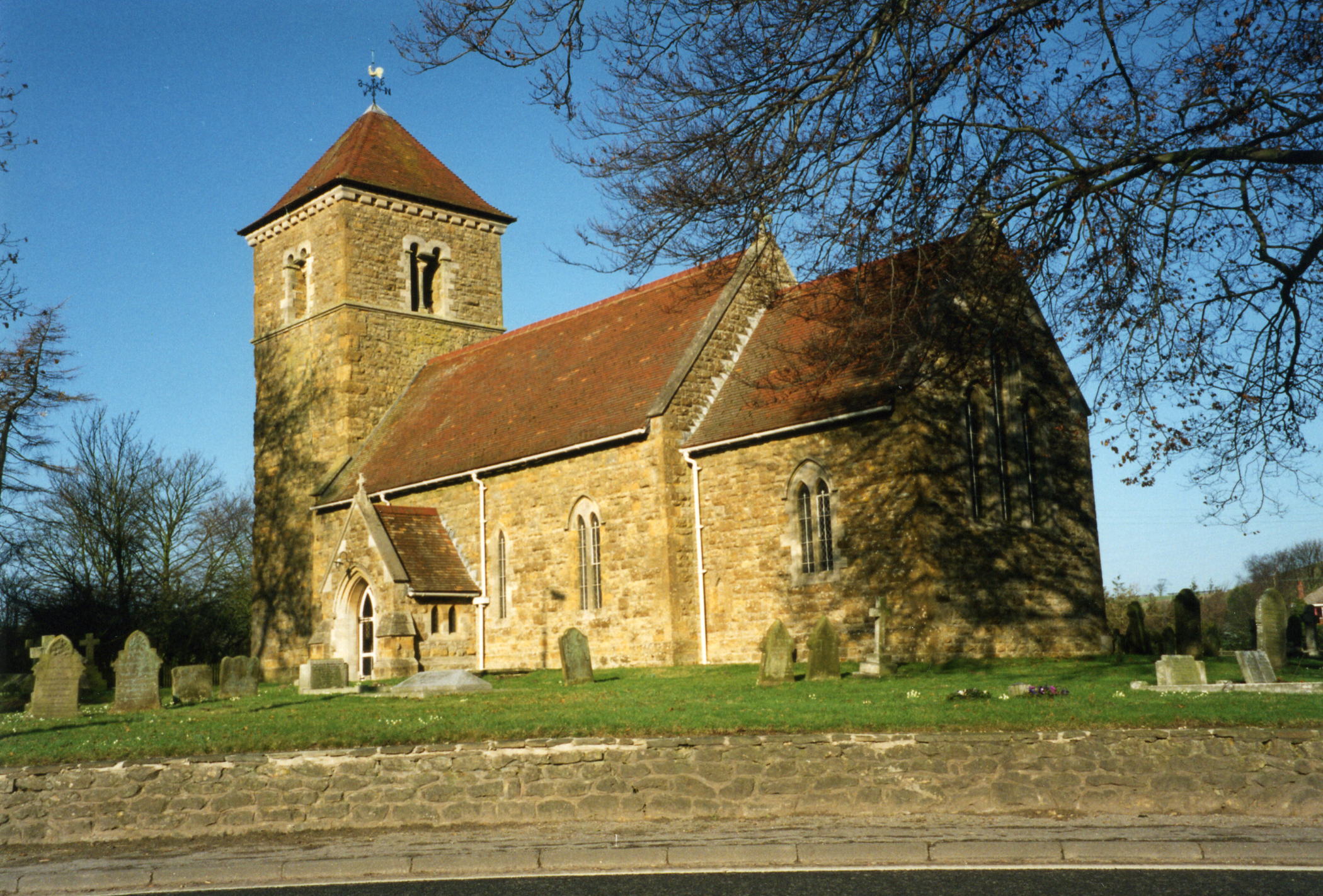
- The Anglican parish church was dedicated to Saint Nicholas.
- The church chancel dates from the 15th century and apparently replaced an older building.
- The church tower dates from the 11th century.
- Richard CROFT has a photograph of the Saxon Tower Arch on Geo-graph, taken in May, 2010.
- The church tower was restored in 1871-72.
- The church itself seats about 100.
- In 1966 the church became a grade II* listed British Heritage building.
- Richard CROFT has a photograph of St. Nicholas Church on Geo-graph, taken in March, 2006.
- Here is a photo of the church, taken by Ron COLE (who retains the copyright):
- Parish register entries exist from 1552.
- The National Burial Index (NBI) covers this parish from 1813 to 1900.
- The Lincolnshire Archives has the parish register for 1559 through 1976.
- The Lincolnshire FHS has published several marriage indexes and a burial index for the Westwold Deanery to make your search easier.
- The Primitive Methodists had a small chapel here. For more on researching these chapel records, see our non-conformist religions page.
- Check our Church Records page for county-wide resources.
- The parish was in the Caistor sub-district of the Caistor Registration District.
- Check our Civil Registration page for sources and background on Civil Registration which began in July, 1837.
Cabourne is a small village and a parish in the Wold valleys, about 1.5 miles north-east of Caistor on the A46 road. The parish covers about 2,900 acres.
If you are planning a visit:
- Cabourne village has a Facebook page if you'd like to connect to locals.
- By automobile, take the A46 arterial east out of Caistor.
- See our touring page for visitor services.
- Ask for a calculation of the distance from Cabourne to another place.
- The 1830 pumphouse in the village is a grade II listed British Heritage building.
- Pelham's Pillar is a 128ft high tower (grade II listed) which was built from 1840 to 1849 by E. J. WILSON's son and grandson. It was dedicated to Lord Yarborough, Charles Anderson PELHAM, who planted 12,532 trees in Cabourne High Wood between 1787 and 1828.
- The national grid reference is TA 1301.
- You'll want an Ordnance Survey Explorer map, which has a scale of 2.5 inches to the mile.
- See our Maps page for additional resources.
You can see maps centred on OS grid reference TA141019 (Lat/Lon: 53.501781, -0.281782), Cabourne which are provided by:
- OpenStreetMap
- Google Maps
- StreetMap (Current Ordnance Survey maps)
- Bing (was Multimap)
- Old Maps Online
- National Library of Scotland (Old Ordnance Survey maps)
- Vision of Britain (Click "Historical units & statistics" for administrative areas.)
- English Jurisdictions in 1851 (Unfortunately the LDS have removed the facility to enable us to specify a starting location, you will need to search yourself on their map.)
- Magic (Geographic information) (Click + on map if it doesn't show)
- GeoHack (Links to on-line maps and location specific services.)
- All places within the same township/parish shown on an Openstreetmap map.
- Nearby townships/parishes shown on an Openstreetmap map.
- Nearby places shown on an Openstreetmap map.
- The name is rendered as Caburne in the 1086 Domesday Book.
- The name Cabourne is also rendered as Caburn in other sources.
- Do Not confuse this place with Claiborne in Kentucky or Cambourne in South Cambridgeshire.
- This place was an ancient parish in Lincolnshire and became a modern Civil Parish when those were established.
- The parish was in the ancient Bradley Haverstoe Wapentake in the West Lindsey district in the parts of Lindsey.
- Cabourne was amalgamated into Swallow Civil Parish some yaears ago.
- Today's district governance is provided by the West Lindsey District Council.
- Bastardy cases would be heard in the Caistor petty session hearings.
- The Common Lands were enclosed here around 1820.
- After the 1834 Poor Law Amendment Act reforms, this parish became part of the Caistor Poor Law Union.
Year Inhabitants 1801 100 1821 105 1831 173 1841 166 1871 184 1881 174 1891 139 1901 161 1931 130 1951 112 1961 156 1971 84 1991 86
- A parochial School was built here in 1856. Attendance in 1871 was about 30.
- For more on researching school records, see our Schools Research page.